The best bet for a long off-road run in Osaka is to choose a section of the paths along the Yodo River. There are nearly 50 km of paths, on both the north and south banks. It’s also a large green space, with Yodogawa River Park spanning several km along both banks. The paths are mainly paved, and are also popular for cycling. Some sections are right along the water, others slightly inland. The south bank is where downtown Osaka is located, with the skyline, iconic Umeda Sky Building, and Osaka Castle. We’ve mapped routes along both banks.
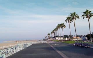
South Bank. We’ve mapped 18 km along the south bank, between the Yodogawa Riverside Park – Kema Area (just east of downtown) east to Yodogawa Riverside Park – Hirakata Area. This is a nearly continuous path along the river, with water views about half the way. Note there aren’t many bridges that are good for pedestrian crossings, so you sorta have to commit to the south bank.
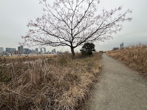
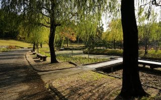
North Bank near Nishinakajima Area. Mark Lowenstein
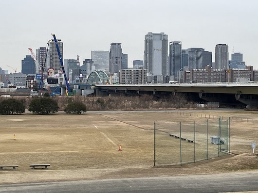
North Bank. We’ve mapped 11 km of paths along the north bank of the Yodo River. The route starts at Tsukamoto , and heads east to Yodogawa Riverside Park – Hitotsuya Wildflower Area. There are some nice water views and great views of the Osaka skyline on the south bank of the river. This western section (Nishinakajima Area) is a good option if you’re staying near the Shin-Osaka train station. From the west end at Tsukamoto, it’s 3 km to Yodogawa Riverside Park – Nishinakajima Area, 5 km to the Yodogawa Golf Club, 8 km, to Yodogawa Riverside Park – Toyosato Area, and 11 km to Yodogawa Riverside Park- Hitotsuya Area.
The best bet for a long off-road run in Osaka is to choose a section of the paths along the Yodo River. There are nearly 50 km of paths, on both the north and south banks. It’s also a large green space, with Yodogawa River Park spanning several km along both banks. The paths are mainly paved, and are also popular for cycling. Some sections are right along the water, others slightly inland. The south bank is where downtown Osaka is located, with the skyline, iconic Umeda Sky Building, and Osaka Castle. We’ve mapped routes along both banks.
South Bank. We’ve mapped 18 km along the south bank, between the Yodogawa Riverside Park – Kema Area (just east of downtown) east to Yodogawa Riverside Park – Hirakata Area. This is a nearly continuous path along the river, with water views about half the way. Note there aren’t many bridges that are good for pedestrian crossings, so you sorta have to commit to the south bank.
North Bank near Nishinakajima Area. Mark Lowenstein
North Bank. We’ve mapped 11 km of paths along the north bank of the Yodo River. The route starts at Tsukamoto , and heads east to Yodogawa Riverside Park – Hitotsuya Wildflower Area. There are some nice water views and great views of the Osaka skyline on the south bank of the river. This western section (Nishinakajima Area) is a good option if you’re staying near the Shin-Osaka train station. From the west end at Tsukamoto, it’s 3 km to Yodogawa Riverside Park – Nishinakajima Area, 5 km to the Yodogawa Golf Club, 8 km, to Yodogawa Riverside Park – Toyosato Area, and 11 km to Yodogawa Riverside Park- Hitotsuya Area.
Scroll Down For Route Maps
Essentials
There are 50 km of paths overall. We've mapped 18 km on the south bank and 11 km on the north bank
Flat
Depends on section chosen
Numerous train/metro stations along the way, just up from the river
This historic castle is surrounded by a gorgeous, seasonally changing park with 4 km and 3 km running tracks. A very popular place for running in Osaka. Running Base offers changing rooms & showers!
Explore 80 temples in an 8 km running route! Lovers of history and culture will delight in this 8 km one-way route, which explores the many temples of the Tennoji ward. Mix of paths and roads. Can easily do one-way using transport.
This is a favorite "home route" of the Kaizuka Running Club, located along the waterfront of Kaizuka city about 40 minutes south of downtown Osaka. 5 km.
Hattori Ryokuchi Park is a lovely spot for a run in the Toyonaka section of Osaka. The park features trails (mainly paved), several small ponds, athletic fields, and a running track. There are several km of paths. We've mapped a 6 km perimeter loop.
Run through former Worlds Fair grounds in this 264 hectare park with beautiful gardens. A perimeter of the park is 5k, but there are also good interior options. There are numerous museums, a Japanese Garden, and other sites.
For those staying in the area of Itami Airport, there's some decent running in Itami Sky Park and then combining Ina River Ground & Higashi Kushiro Athletic Park along the Ina River.
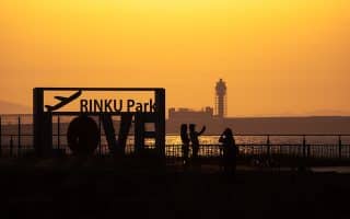
A perfect waterfront sunset run near the Kansai Airport in Izumisano City. Multiple options, including ~7 km or ~11 km routes along mainly waterfront paths.
Share your feedback on this route and see that of other Great Runs users. Click on the image icon to upload a photo. And please let us know if there are notes or changes we should incorporate!
Subscribe
1 Comment
Oldest
Newest
Inline Feedbacks
View all comments
Essentials
There are 50 km of paths overall. We've mapped 18 km on the south bank and 11 km on the north bank
Flat
Depends on section chosen
Numerous train/metro stations along the way, just up from the river


Review or Comment on This Route/Share a Photo!
Share your feedback on this route and see that of other Great Runs users. Click on the image icon to upload a photo. And please let us know if there are notes or changes we should incorporate!