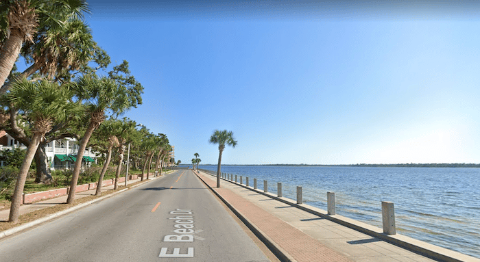
In the area of downtown Panama City, it’s possible to stitch together a pleasant waterfront run, with views to Saint Andrew Bay and East Bay. It’s mainly on waterside roads with a good shoulder or sidewalk. The heart of the route is the 3.5 miles between Oaks by the Bay Park and Bunkers Point, using the roads alongside the water – W. Beach Rd./US 98 and East Beach Rd. At the western end along US 98 there’s a sidewalk on the side of the street opposite the water. The prettiest section is the 0.5 miles on East Beach Rd. with a wide sidewalk and unobstructed water views. There are a also a couple of pleasant sections on pretty residential streets with a nice tree canopy.
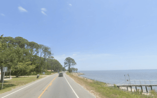
For a longer run, continue southeast past Bunkers Point for another ~1 mile to Town Point or do the full ~3 mile loop around Bunkers Cove.
In the area of downtown Panama City, it’s possible to stitch together a pleasant waterfront run, with views to Saint Andrew Bay and East Bay. It’s mainly on waterside roads with a good shoulder or sidewalk. The heart of the route is the 3.5 miles between Oaks by the Bay Park and Bunkers Point, using the roads alongside the water – W. Beach Rd./US 98 and East Beach Rd. At the western end along US 98 there’s a sidewalk on the side of the street opposite the water. The prettiest section is the 0.5 miles on East Beach Rd. with a wide sidewalk and unobstructed water views. There are a also a couple of pleasant sections on pretty residential streets with a nice tree canopy.
For a longer run, continue southeast past Bunkers Point for another ~1 mile to Town Point or do the full ~3 mile loop around Bunkers Cove.

Review or Comment on This Route/Share a Photo!
Share your feedback on this route and see that of other Great Runs users. Click on the image icon to upload a photo. And please let us know if there are notes or changes we should incorporate!