The city of Carlsbad, located 35 miles north of San Diego, is a popular visitor destination and has some great running options, including some of the longest stretches of coastal road with unobstructed water views. Our recommendations on the best places to run in Carlsbad:
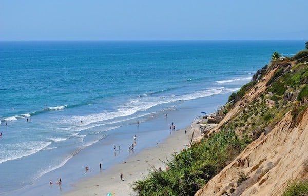
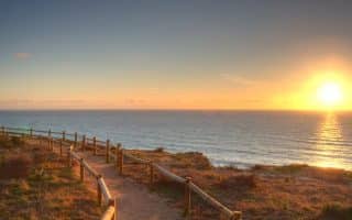
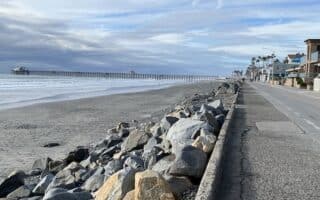
Oceanfront Roads. Carlsbad boasts some of the longest stretches of coastal road with unobstructed water views in the San Diego area. We’ve mapped a route that runs for nearly 6 miles from the Ponto State Beach Jetty north to Carlsbad Village. It’s a mix of road-side bike path and some separate pedestrian sections. One could break this up into two runs. From the Ponto State Beach Jetty (Tower 22) to Cannon Rd., it’s ~3 miles. About 2/3 of this is on the road going through the South Carlsbad State Beach Campground.
Even more spectacular is the section north of Cannon Rd. along Carlsbad Blvd. There are wonderful ocean views, an 0.5-mile above the ocean at Terra Mar Point, and then a really pretty section along the popular Tamarack Surf Beach, where there’s a separated path from the road.
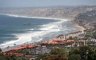
Beach Running. The beaches in this area are terrific for running, with fairly firm sand near the water. Best stretches in the Carlsbad are the ~2.5 miles along South Carlsbad State Beach/North Pronto Beach till about the Hilton. In the Carlsbad Village area, there’s ~1 mile of nice running along Tamarack Surf Beach.
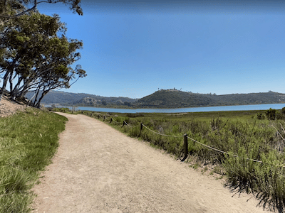
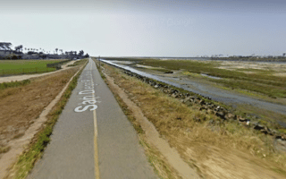
Batiquitos Lagoon Trail. Google Street View
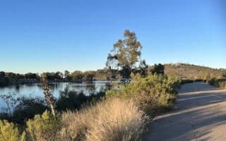
Batiquitos Lagoon Trail. This is an easy and scenic trail for running. The Batiquitos Lagoon lies just east of I-5 between Encinitas and Carlsbad, and features a 1.6 mile trail along the water, with nice views to the wetlands. There are five public parking lots providing access to the trail, one by the Nature Center and four on Batiquitos Drive. Unfortunately, there’s not good pedestrian access between the beach/coastal road and the lagoon trail.Self-Guided Trail Guide. ROUTE MAP
Rail Trail & Coastal Loop.In Carlsbad Village, there’s a 1-mile trail called the Coastal Rail Trail…that doesn’t actually run along the coast. It runs inland between Tamarack Ave. & Carlsbad Village Dr. There’s a link to it from Carlsbad Blvd. so one can do a nice ~5k loop incorporating the trail and the coastal road. See the ROUTE MAP
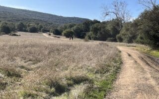
Lake Calavera Preserve & Carlsbad Highlands Ecological Preserve. This is a great option for some scenic, easy-to-moderate trail running. Located 4 miles inland from Carlsbad Village, the Preserve features 6-7 miles of trails around the lake and up some hills to some lovely viewpoints. Most popular is the 3.2 mile Lake Loop (180 foot gain). For a longer run or some variety, connect to the 1-mile Solar System Trail, which leads to Sage Creek High School (and a running track!), or enjoy the scenic pasture-like trails of the adjacent Carlsbad Highlands Ecological Preserve. Note: the trails have a varied surface, ranging from paved to sand to firmer dirt. TRAIL MAP
The city of Carlsbad, located 35 miles north of San Diego, is a popular visitor destination and has some great running options, including some of the longest stretches of coastal road with unobstructed water views. Our recommendations on the best places to run in Carlsbad:
Oceanfront Roads. Carlsbad boasts some of the longest stretches of coastal road with unobstructed water views in the San Diego area. We’ve mapped a route that runs for nearly 6 miles from the Ponto State Beach Jetty north to Carlsbad Village. It’s a mix of road-side bike path and some separate pedestrian sections. One could break this up into two runs. From the Ponto State Beach Jetty (Tower 22) to Cannon Rd., it’s ~3 miles. About 2/3 of this is on the road going through the South Carlsbad State Beach Campground.
Even more spectacular is the section north of Cannon Rd. along Carlsbad Blvd. There are wonderful ocean views, an 0.5-mile above the ocean at Terra Mar Point, and then a really pretty section along the popular Tamarack Surf Beach, where there’s a separated path from the road.
Beach Running. The beaches in this area are terrific for running, with fairly firm sand near the water. Best stretches in the Carlsbad are the ~2.5 miles along South Carlsbad State Beach/North Pronto Beach till about the Hilton. In the Carlsbad Village area, there’s ~1 mile of nice running along Tamarack Surf Beach.
Batiquitos Lagoon Trail. Google Street View
Batiquitos Lagoon Trail. This is an easy and scenic trail for running. The Batiquitos Lagoon lies just east of I-5 between Encinitas and Carlsbad, and features a 1.6 mile trail along the water, with nice views to the wetlands. There are five public parking lots providing access to the trail, one by the Nature Center and four on Batiquitos Drive. Unfortunately, there’s not good pedestrian access between the beach/coastal road and the lagoon trail.Self-Guided Trail Guide. ROUTE MAP
Rail Trail & Coastal Loop.In Carlsbad Village, there’s a 1-mile trail called the Coastal Rail Trail…that doesn’t actually run along the coast. It runs inland between Tamarack Ave. & Carlsbad Village Dr. There’s a link to it from Carlsbad Blvd. so one can do a nice ~5k loop incorporating the trail and the coastal road. See the ROUTE MAP
Lake Calavera Preserve & Carlsbad Highlands Ecological Preserve. This is a great option for some scenic, easy-to-moderate trail running. Located 4 miles inland from Carlsbad Village, the Preserve features 6-7 miles of trails around the lake and up some hills to some lovely viewpoints. Most popular is the 3.2 mile Lake Loop (180 foot gain). For a longer run or some variety, connect to the 1-mile Solar System Trail, which leads to Sage Creek High School (and a running track!), or enjoy the scenic pasture-like trails of the adjacent Carlsbad Highlands Ecological Preserve. Note: the trails have a varied surface, ranging from paved to sand to firmer dirt. TRAIL MAP
One of the best convention center/airport runs in the world. Scenic multi-use paths run through several parks along North San Diego Bay. It's up to 7 miles from the Convention Center to Liberty Station Park, with water views the whole way.
Another great running option in the airport/convention center/downtown area. Harbor Island, Seaport Village, waterfront park. All along the water, numerous distance options.
One of the great urban parks of America, featuring 65 miles of trails through gardens, groves, and important sights such as the Zoo and several museums. Many options for running, good variety of terrain and challenge.
A 46,000 acre aquatic playground. We’ve mapped a well-known 12-mile loop, almost all of it on well-marked off-road paths, with water views, lovely parks, beaches, bridges, and an island.
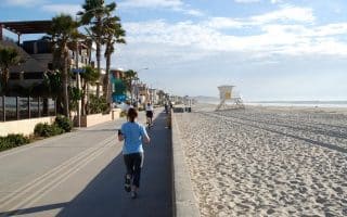
Classic beach boardwalk run on a 3.2 mile multi-use path between North Pacific Beach and South Mission Beach. A festive scene, with water views and lots of shops, bars & restaurants. Beach also runnable. Combine w/best sections of Mission Bay route.
A good option for runners who want a long, flat, off-road trail in the Mission Bay/Mission Valley area. We've mapped a 7.5 mile one-way route from Ocean Beach to I-805 in Mission Valley. The westernmost 3 miles is the prettiest section.
At the tip of Point Loma, with fantastic views of the water, San Diego downtown & harbor, and Coronado Island. Also includes the 2.2-mile RT Bayside Trail, down to the water.
A good running option just inland from Mission Bay. Pleasant campus for running, then 6+ miles of trails in Tecolote Canyon Nature Park. Can be combined with paths along Tecolote Shores, Fiesta Island, and Southern Shores Park.
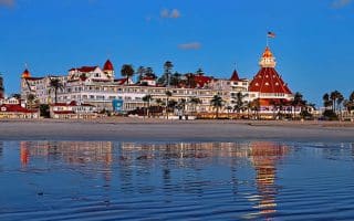
A destination in San Diego since the Hotel Del Coronado was built in 1900. Numerous running options, much of it on off-road paths, all open and with great ocean views.
Some nice running in south San Diego near the Mexico border. Enjoy miles of trails around wetlands in the Tijuana Slough/River estuary area. There's also some good beach running in the area.
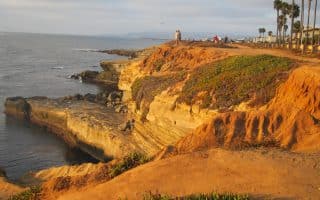
Sunset Cliffs in Ocean Beach is a great place to run in San Diego, staying high on windy cliffs with great views. A real treat at sunset. At the end of the road, hike down the cliffs onto the beach.
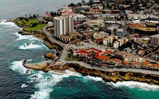
A beautiful and affluent seaside community 13 miles north of San Diego. Wonderful oceanside roads and trails, and a hilly residential community with gorgeous homes and views.
A beautiful State Preserve of 2,000 acres, 5 miles north of San Diego, incorporating the rare Torrey pine. Run-nable hillside hiking trails with great ocean views. Also great running on the beach here.
The 5 miles from La Jolla Shores to Torrey Pines is one of the ultimate beach runs. Big wide beach, towering cliffs overhead, crashing waves, seamless firm sand, sunsets….it doesn’t get better than this.
Pleasant campus situated between La Jolla Shores and Torrey Pines, just west of I-5. Nice paths and a shaded canopy make for a nice standalone run or as an add-on to nearby routes.
Some scenic, gentle trail running in the Sorrento Hills/Mira Mesa area! Nice variety of canyon/ranch type terrain, gorgeous live oaks and sycamores. Easiest is the 5+ mile Los Peñasquitos Canyon Trail. There are also more challenging options.
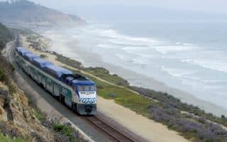
A unique running opportunity. Take the Coaster train north from Solana Beach and then run back on the Coast Highway. One can go as far as Oceanside, which is 16 miles. Bike lane along the road, ocean views the whole way.
5,800-acre regional park located in La Mesa. The 3-mile path along Lake Murray is popular with runners. There are also 30+ miles of trail running, ranging from the easy Grassland Loop to a 3 mile climb to the top of Cowles Mountain.
A 5-mile loop trail around a reservoir in the Scripps Ranch area, northeast of downtown. Popular spot for running, bicycling, and other activities. Paved park service road is relatively traffic free. Nice views to water and valleys.
Best running options in Encinitas include ~6 miles of continuous beach from Swami's Beach to Grandview Beach, a 1.6 mile bike path along San Elijo State Beach, and 7 miles of easy trails at the San Elijo Lagoon Ecological Reserve.
There's a nice variety of running options in Oceanside, including the Strand Path along the beach, a scenic loop around the Marina, the 9-mile San Luis Rey River Multi-Use Path, and lovely trails in Guajome Regional Park.
Share your feedback on this route and see that of other Great Runs users. Click on the image icon to upload a photo. And please let us know if there are notes or changes we should incorporate!


Review or Comment on This Route/Share a Photo!
Share your feedback on this route and see that of other Great Runs users. Click on the image icon to upload a photo. And please let us know if there are notes or changes we should incorporate!