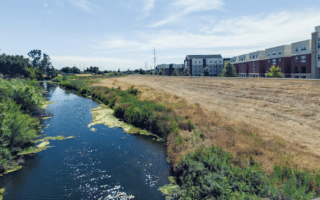
The Bear Creek Trail is another good opportunity to rack up some easy, flat off-road miles in the Stockton area. The levee type path runs along Bear Creek, which is located a couple of miles north of downtown Stockton. There are views of the water the whole way, though the creek can be dry, depending on the season. The trail is mainly paved.
The trail starts at the intersection of Eight Mile Rd. & Davis Rd., and runs south for 1 mile. There, you can head in either direction. Heading west, the trail goes for 1.5 miles to Trinity Pkwy (just west of I-5). Headed east, it’s 2.8 miles to West Ln., where it’s possible to continue east for many more miles on a gravel surface.
We’ve mapped a 12 mile route starting at Eight Mile Rd., west to I-5 and then east to West Ln.
Note: this path is open and exposed. Use caution in the heat!

Review or Comment on This Route/Share a Photo!
Share your feedback on this route and see that of other Great Runs users. Click on the image icon to upload a photo. And please let us know if there are notes or changes we should incorporate!