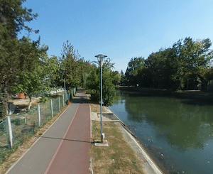
The Bega River runs through Timișoara, and there are lovely paths alongside it. In the heart of the city, there are paved paths along both banks of the river, making for a fun 6.4 km loop between the Maria Bridge & Dacilor Bridge. There are nice views of the river, and the historic centre. This main route is also part of a verdant linear park route, with several waterfront parks featuring additional paths. There’s also a running track at Ştiința Stadium off the south bank, just west of the Andrei Șaguna Bridge. Bonus: much of the path along the river is lit at night.
Longer Run. From the Dacilor Bridge, it’s possible to follow the river east for another 5.2 km. Take the cycle path along the road for 1 km, run through Parcul Uzinei (park), and continue for another 3.8 km on a cycle path. This section gets more rural and is away from the river in sections, passing farm fields.
Cycle Path to Serbia. Headed further west, there’s a long-distance cycle path that follows the river for nearly 40 km to the Serbian border. Mix of paved & gravel surface. INFORMATION
Google Street View
The Bega River runs through Timișoara, and there are lovely paths alongside it. In the heart of the city, there are paved paths along both banks of the river, making for a fun 6.4 km loop between the Maria Bridge & Dacilor Bridge. There are nice views of the river, and the historic centre. This main route is also part of a verdant linear park route, with several waterfront parks featuring additional paths. There’s also a running track at Ştiința Stadium off the south bank, just west of the Andrei Șaguna Bridge. Bonus: much of the path along the river is lit at night.
Longer Run. From the Dacilor Bridge, it’s possible to follow the river east for another 5.2 km. Take the cycle path along the road for 1 km, run through Parcul Uzinei (park), and continue for another 3.8 km on a cycle path. This section gets more rural and is away from the river in sections, passing farm fields.
Cycle Path to Serbia. Headed further west, there’s a long-distance cycle path that follows the river for nearly 40 km to the Serbian border. Mix of paved & gravel surface. INFORMATION
Scroll Down For Route Maps
Essentials
Main loop is 6.4 km (4 miles). Optional eastern extension is up to 5 km one-way. Also cycle path headed west for many km
Fairly flat
Choose your start point: Cathedral Park is a central location
A classic European riverfront park run. Enjoy a run through seven significant parks along the Bega River, each with a distinct feel and features. The 'outline' route is 7.5 km, with options for additional paths in the parks. There's a running track on the south bank.
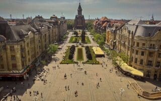
This 5k 'runseeing' tour of Timișoara hits the highlights of the historic Cetate neighborhood, featuring important squares, well-preserved Austro-Hungarian fin de siècle architectural architecture, and some small parks. Good add-on options for a longer run.
An exploration of the historic Elisabetin neighborhood. Highlights include its architecture, running track, loop around Stadionul Dan Păltinișanu popular with runners, Carmen Sylva Park, Lidia Park.
Share your feedback on this route and see that of other Great Runs users. Click on the image icon to upload a photo. And please let us know if there are notes or changes we should incorporate!
Subscribe
0 Comments
Oldest
Newest
Inline Feedbacks
View all comments
Essentials
Main loop is 6.4 km (4 miles). Optional eastern extension is up to 5 km one-way. Also cycle path headed west for many km
Fairly flat
Choose your start point: Cathedral Park is a central location


Review or Comment on This Route/Share a Photo!
Share your feedback on this route and see that of other Great Runs users. Click on the image icon to upload a photo. And please let us know if there are notes or changes we should incorporate!