Santa Rosa is another winery center in the area, 25 miles from Sonoma. From downtown, a series of multi-use paths radiates from the center. Our recommendations on the best places to run in Santa Rosa:
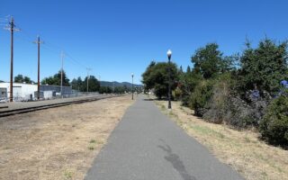
Joe Rodota Trail: The Joe Rodota Trail, an 8.5 mile paved multi-use trail to the center of Sebastopol, is one of the best running choices in downtown Santa Rosa. The park surrounding the Prince Memorial Greenway is one of the highlights. Runners can also connect to the sculpture gardens of Juilli 1 Xard Park on the east end, or the Laguna de Santa Rosa Trail and West County Regional Trail on the west end. The Laguna de Santa Rosa Trail is a flat gravel 1.8 mile loop around Kelly Pond. Round out your workout with the outdoor fitness equipment at Roseland Village. Trail MAP.
—Sonoma County Tourism
West County Regional Trail: In the corridor of the former Petaluma and Santa Rosa Railway, the West County Regional Trail is now a 5.6 mile paved multi-use path between Sebastopol and Forestville. Most of the trail follows along Highway 116, but runners can access the trail at several points, including from the south end at North Main Street, Sebastopool or from the north end at Pajaro Lane in Forrestville. Trail MAP.
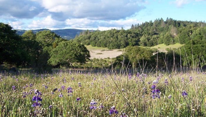
Trione-Annadel State Park: The favorite for running in the Santa Rosa area, Annadel State Park, features many miles of paths just to the east of Santa Rosa. With so much varied terrain, runners can find a route to match any comfort level — from fire roads to more rugged trail running. For a moderate, non-technical trail run, many runners use Spring Creek and the Lake Trail out to Lake Ilsanjo. Park MAP.
—Sonoma County Tourism
Spring Lake/Howarth Park: At the north end of Annadel State Park, the green space continues into Spring Lake Park and Howarth Park, which offer some great running of their own. The Spring Creek Trail follows a 2.2 mile mostly paved loop around the scenery of Spring Lake. Another ~1 mile branch stretches west past Lake Ralphine into Howarth Park. The Spring Creek Trail connects to Annadel Park in the east for more mileage. Spring Lake Loop Route MAP.
Foothill Regional Park: This 211 acre park in Windsor, about 15 minutes north of Santa Rosa, is a dream for gentle trail running over the undulating foothills of the Mayacamas Mountains. With 7 miles of trails, there are many loop and out and back options to choose from. One favorite is the smooth, accessible Three Lakes Trail. It’s only about 1 mile long, but can be combined with other trails, such as the Alta Vista and Oakwood Trail for a gorgeous but non-technical trail loop. Park MAP with trail options & distances.
—Sonoma County Tourism
Hood Mountain Regional Park: With 1,750 acres just east of Santa Rosa, Hood Mountain includes 19 miles of trails. Popular (but challenging) scenic routes lead to the summit of Hood Mountain and Gunsight Rock, but there are less strenuous options that are better suited to running. One good choice is the Santa Rosa Creek Trail from the Los Alamos Trailhead. Park MAP.
Lake Sonoma Trails: Lake Sonoma is located in Cloverdale, in the northern reaches of Sonoma County. The expansive shoreline of this park offers plenty of recreation activities, including about 40 miles of runnable trails. The South Lake Trail, accessible from the South Lake Trailhead, is one of the best options for an out and back of up to 23 miles.
—Sonoma County Tourism
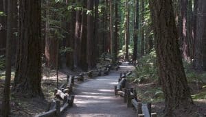
Armstrong Redwoods State Natural Reserve: This collection of redwoods just north of Guerneville is a spectacular foggy grove with some 20 miles of trails through the forest. The accessible Pioneer Nature Trail and the East Austin Creek Fire Road are some of the best options for running. Park MAP.
Santa Rosa is another winery center in the area, 25 miles from Sonoma. From downtown, a series of multi-use paths radiates from the center. Our recommendations on the best places to run in Santa Rosa:
Joe Rodota Trail: The Joe Rodota Trail, an 8.5 mile paved multi-use trail to the center of Sebastopol, is one of the best running choices in downtown Santa Rosa. The park surrounding the Prince Memorial Greenway is one of the highlights. Runners can also connect to the sculpture gardens of Juilli 1 Xard Park on the east end, or the Laguna de Santa Rosa Trail and West County Regional Trail on the west end. The Laguna de Santa Rosa Trail is a flat gravel 1.8 mile loop around Kelly Pond. Round out your workout with the outdoor fitness equipment at Roseland Village. Trail MAP.
—Sonoma County Tourism
West County Regional Trail: In the corridor of the former Petaluma and Santa Rosa Railway, the West County Regional Trail is now a 5.6 mile paved multi-use path between Sebastopol and Forestville. Most of the trail follows along Highway 116, but runners can access the trail at several points, including from the south end at North Main Street, Sebastopool or from the north end at Pajaro Lane in Forrestville. Trail MAP.
Trione-Annadel State Park: The favorite for running in the Santa Rosa area, Annadel State Park, features many miles of paths just to the east of Santa Rosa. With so much varied terrain, runners can find a route to match any comfort level — from fire roads to more rugged trail running. For a moderate, non-technical trail run, many runners use Spring Creek and the Lake Trail out to Lake Ilsanjo. Park MAP.
—Sonoma County Tourism
Spring Lake/Howarth Park: At the north end of Annadel State Park, the green space continues into Spring Lake Park and Howarth Park, which offer some great running of their own. The Spring Creek Trail follows a 2.2 mile mostly paved loop around the scenery of Spring Lake. Another ~1 mile branch stretches west past Lake Ralphine into Howarth Park. The Spring Creek Trail connects to Annadel Park in the east for more mileage. Spring Lake Loop Route MAP.
Foothill Regional Park: This 211 acre park in Windsor, about 15 minutes north of Santa Rosa, is a dream for gentle trail running over the undulating foothills of the Mayacamas Mountains. With 7 miles of trails, there are many loop and out and back options to choose from. One favorite is the smooth, accessible Three Lakes Trail. It’s only about 1 mile long, but can be combined with other trails, such as the Alta Vista and Oakwood Trail for a gorgeous but non-technical trail loop. Park MAP with trail options & distances.
—Sonoma County Tourism
Hood Mountain Regional Park: With 1,750 acres just east of Santa Rosa, Hood Mountain includes 19 miles of trails. Popular (but challenging) scenic routes lead to the summit of Hood Mountain and Gunsight Rock, but there are less strenuous options that are better suited to running. One good choice is the Santa Rosa Creek Trail from the Los Alamos Trailhead. Park MAP.
Lake Sonoma Trails: Lake Sonoma is located in Cloverdale, in the northern reaches of Sonoma County. The expansive shoreline of this park offers plenty of recreation activities, including about 40 miles of runnable trails. The South Lake Trail, accessible from the South Lake Trailhead, is one of the best options for an out and back of up to 23 miles.
—Sonoma County Tourism
Armstrong Redwoods State Natural Reserve: This collection of redwoods just north of Guerneville is a spectacular foggy grove with some 20 miles of trails through the forest. The accessible Pioneer Nature Trail and the East Austin Creek Fire Road are some of the best options for running. Park MAP.
Running options in the heart of wine country include multi-use paths, scenic roads, and the Bartholomew Park Winery's trails. Good trail running at Sonoma Overlook Trail, Sonoma Valley Regional Park, and Jack London State Park.
The "egg-basket" of Petaluma is famous for its chickens and foodie culture, but there is also plenty of running in this riverfront town, from the scenic expanses of Helen Putnam and Shollenberger Parks, to the many sidewalks and bike paths along Lynch Creek.
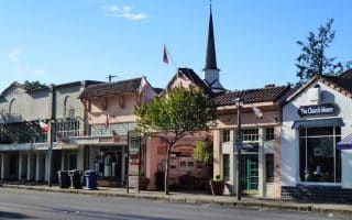
Some nice running options in this small city on the Russian River: Foss Creek Pathway, Healdsburg Ridge Open Space Preserve, and some quieter, scenic roads passing by vineyards & orchards.
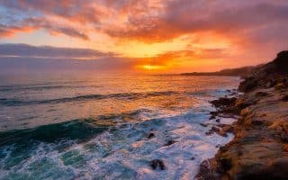
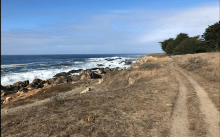
There are great beach and bluffside running options in the coastal area of Sonoma County. Highlights are Doran Regional Park, the Sea Ranch and Gualala Bluff Trails, Salt Point State Park, and Sonoma Coast State Park.
Planned community in Sonoma County with access to miles of spectacular trails and beaches. The signature run is the 3-mile coastal bluff trail, which features spectacular views and a wide, gentle surface.
Share your feedback on this route and see that of other Great Runs users. Click on the image icon to upload a photo. And please let us know if there are notes or changes we should incorporate!


Review or Comment on This Route/Share a Photo!
Share your feedback on this route and see that of other Great Runs users. Click on the image icon to upload a photo. And please let us know if there are notes or changes we should incorporate!