Aix-en-Provence, located 30 km north of Marseille, is a university city known as the birthplace of Post-Impressionist painter Paul Cézanne. Our recommendations on the best places to run in Aix-en-Provence:
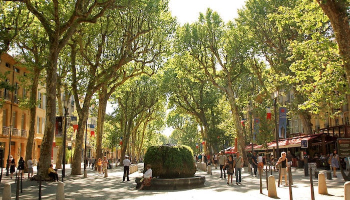
Promenade de la Torse: A favorite place to run in Aix-en-Provence is the tranquil Promenade de la Torse around the river park. This combination of paved and hard-packed gravel trail travels through a tree-lined riverside for a loop of roughly 2.5 km. For a longer run, continue up Avenue Saint Jerome to Parc Jourdan and loop around the gardens there. This brings the length up to about 6.7 km. ROUTE MAP.
Promenade de l’Arc: There is more great running in the south end of AIX-EN-PROVENCE along the La Torse river. Start in Val de l’Arc park and head south along the river, bending inland at Chemin de la Cible. Wind west along the water until the D8N bridge, then turn LEFT to cross to Chemin du Viaduc. This will loop you back east to the start of the course for a total of 6.5 km. ROUTE MAP.
Centre-Ville & Cézanne’s Trail. The local government has created a wonderful walking trail celebrating Cézanne’s life and work in a number of places. It starts at the Tourist Information Office. The trail is marked with nails stamped “C”. You can also create your own run in Centre Ville. Great maze of narrow streets, with pretty, older buildings. A nice add-on to Promenade de la Torse just to the south. Get up early to beat the crowds! MAP & INFO
Lac de Peyrolles: About 30 minutes from Aix-en-Provence by car, the lake is an old quarry that was filled with water and is now a major rowing and swimming hub. It’ssurrounded by a large public park, including a scenic dirt running path around the lake. The loop is ~5 km, but runners traveling from the Peyrolles en Provence bus stop will add on an additional 2 km. ROUTE MAP.
Saint-Victore Mountain. There are some great running opportunities around this prominent 1,011m rocky summit near Aix. For a popular 10.5 km loop around the mountain, start in Puloubier, and follow the walk, which leads to the heart of the Côtes de Provence, the Invalids of the Foreign Legion Institute and the Uniform Museum. ROUTE MAP
Aix-en-Provence, located 30 km north of Marseille, is a university city known as the birthplace of Post-Impressionist painter Paul Cézanne. Our recommendations on the best places to run in Aix-en-Provence:
Promenade de la Torse: A favorite place to run in Aix-en-Provence is the tranquil Promenade de la Torse around the river park. This combination of paved and hard-packed gravel trail travels through a tree-lined riverside for a loop of roughly 2.5 km. For a longer run, continue up Avenue Saint Jerome to Parc Jourdan and loop around the gardens there. This brings the length up to about 6.7 km. ROUTE MAP.
Promenade de l’Arc: There is more great running in the south end of AIX-EN-PROVENCE along the La Torse river. Start in Val de l’Arc park and head south along the river, bending inland at Chemin de la Cible. Wind west along the water until the D8N bridge, then turn LEFT to cross to Chemin du Viaduc. This will loop you back east to the start of the course for a total of 6.5 km. ROUTE MAP.
Centre-Ville & Cézanne’s Trail. The local government has created a wonderful walking trail celebrating Cézanne’s life and work in a number of places. It starts at the Tourist Information Office. The trail is marked with nails stamped “C”. You can also create your own run in Centre Ville. Great maze of narrow streets, with pretty, older buildings. A nice add-on to Promenade de la Torse just to the south. Get up early to beat the crowds! MAP & INFO
Lac de Peyrolles: About 30 minutes from Aix-en-Provence by car, the lake is an old quarry that was filled with water and is now a major rowing and swimming hub. It’ssurrounded by a large public park, including a scenic dirt running path around the lake. The loop is ~5 km, but runners traveling from the Peyrolles en Provence bus stop will add on an additional 2 km. ROUTE MAP.
Saint-Victore Mountain. There are some great running opportunities around this prominent 1,011m rocky summit near Aix. For a popular 10.5 km loop around the mountain, start in Puloubier, and follow the walk, which leads to the heart of the Côtes de Provence, the Invalids of the Foreign Legion Institute and the Uniform Museum. ROUTE MAP
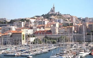
The signature run in Marseille, from Pharo Cove near the Old Fort to Prado Beach. Great views of the Mediterranean along the roadside path, passing above coves and along beaches. 5.3 km one-way, with good bus options for the return.
Former Château estate is now a public park with formal gardens, fountains, and a small lake with pleasant cafe. There are lovely paths around three formal gardens, ~2km, plus the 1k Sentier de l'Huevaune (path) on the north side.
A 'runseeing' tour comprising many of historic Marseille's most important sights. The 6k short version features the old port, Cathédrale La Major, Vieille Charite and the Maison de la Boule. The longer run adds a hilly 4k RT, on Blvd. Tellene up to Notre-Dame de la Garde.
A tour of some of the main commercial areas of Marseille. The highlight is the Canebière, a wide boulevard stretches eastward from the Old Port (Vieux Port) to the Réformés quarter. Several other pedestrian-only streets as well.
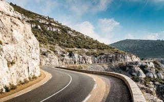
A spectacular 20 km one-way run along the route of a well-known road race. Great views, and hilly! It's possible to run one-way and take the train back to Marseille. Or, take the train to Cassis, and run the more downhill route to Marseille.
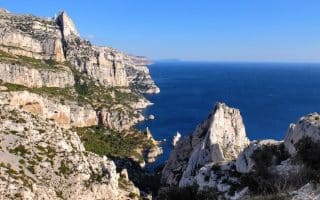
A beautiful and rugged national park along the Mediterranean, 15 km south of Marseille. 'Calanques' means 'inlets. Wonderful, hilly trails with great coastal views. Heaven for serious trail runner. There are a few, gentler 'walking' trails good for running.
Share your feedback on this route and see that of other Great Runs users. Click on the image icon to upload a photo. And please let us know if there are notes or changes we should incorporate!


Review or Comment on This Route/Share a Photo!
Share your feedback on this route and see that of other Great Runs users. Click on the image icon to upload a photo. And please let us know if there are notes or changes we should incorporate!