Montaña de Oro State Park is one of the most spectacular places for running on California’s Central Coast. This large oceanside park features runnable coastal paths, beaches, cliffs, and hills — just a fantastic variety for running. Here are some of our favorites. Note:Pecho Valley Rd., the main park road, is runnable but there is no shoulder and considerable traffic at times. PARK INFO & MAP
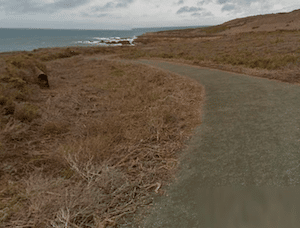
Bluff Trail. Google Street View
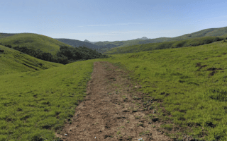
Bluff Trail. 2.1 miles one-way, 111 foot gain. A wide and runnable trail along the coast, with great ocean views. The trail runs for 2.1 miles between a southern end parking lot off Pecho Valley Rd. and a northern lot near Spooner’s Cove. To make it a shorter loop, take Pecho Valley Rd. for the return (3.3 miles total). ROUTE MAP
Point Buchon Trail.3.7 miles one-way. 200 foot gain. This is similar to the Bluff Trail but a bit more rugged and remote. From the southern parking lot, the trail runs south along the coast for up to 3.7 miles toward Diablo Canyon. Can be combined with the Bluff Trail for a nearly 6-mile (one-way) coastal run! ROUTE MAP
Trails North of Spooner’s Cove. There are numerous trail here, between the park road and the ocean, running for 2+ miles. Dune Trail is decent for running but a bit more rugged. Canopy Trail has a lovely canopy and is runnable but narrower. At the northern end, trails and a road lead down to Sandspit Beach.
Sandspit Beach/Morro Bay State Park. At the northern end of Montaña de Oro State Park, trails lead to Sandspit Beach, which is gorgeous, undeveloped, and wonderful for running. The sand is reliably compact near low tide. Sandspit Beach turns into Morro Bay State Park Beach at the northern end, for up to 5 miles of beach running.
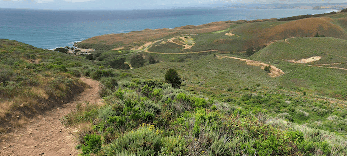
Hill Trails. Google Street View
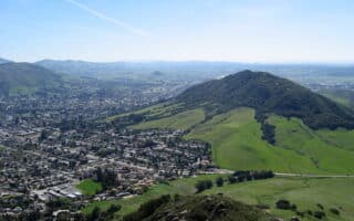
Hill Trails. There’s a large network of trails in the hills east of Pecho Valley Rd. This area is heaven for trail runners and mountain bikers. The terrain is fairly open, leading through scrub and grassland, and there are wonderful mountain and coastal views. There are options for steeper trails leading to Valencia Peak, and at the northern end of the park, trails (such as the Rim Trail) that lead to Broderson Peak. There are also gentler, switchback-ey type trail that run along the hills rather than up them. One good loop from the northern end parking lot, combines the Islay Creek Rd. trail and the Reservoir Flats Trail. 2.5-miles, 220 foot gainROUTE MAP
Montaña de Oro State Park is one of the most spectacular places for running on California’s Central Coast. This large oceanside park features runnable coastal paths, beaches, cliffs, and hills — just a fantastic variety for running. Here are some of our favorites. Note:Pecho Valley Rd., the main park road, is runnable but there is no shoulder and considerable traffic at times. PARK INFO & MAP
Bluff Trail. Google Street View
Bluff Trail. 2.1 miles one-way, 111 foot gain. A wide and runnable trail along the coast, with great ocean views. The trail runs for 2.1 miles between a southern end parking lot off Pecho Valley Rd. and a northern lot near Spooner’s Cove. To make it a shorter loop, take Pecho Valley Rd. for the return (3.3 miles total). ROUTE MAP
Point Buchon Trail.3.7 miles one-way. 200 foot gain. This is similar to the Bluff Trail but a bit more rugged and remote. From the southern parking lot, the trail runs south along the coast for up to 3.7 miles toward Diablo Canyon. Can be combined with the Bluff Trail for a nearly 6-mile (one-way) coastal run! ROUTE MAP
Trails North of Spooner’s Cove. There are numerous trail here, between the park road and the ocean, running for 2+ miles. Dune Trail is decent for running but a bit more rugged. Canopy Trail has a lovely canopy and is runnable but narrower. At the northern end, trails and a road lead down to Sandspit Beach.
Sandspit Beach/Morro Bay State Park. At the northern end of Montaña de Oro State Park, trails lead to Sandspit Beach, which is gorgeous, undeveloped, and wonderful for running. The sand is reliably compact near low tide. Sandspit Beach turns into Morro Bay State Park Beach at the northern end, for up to 5 miles of beach running.
Hill Trails. Google Street View
Hill Trails. There’s a large network of trails in the hills east of Pecho Valley Rd. This area is heaven for trail runners and mountain bikers. The terrain is fairly open, leading through scrub and grassland, and there are wonderful mountain and coastal views. There are options for steeper trails leading to Valencia Peak, and at the northern end of the park, trails (such as the Rim Trail) that lead to Broderson Peak. There are also gentler, switchback-ey type trail that run along the hills rather than up them. One good loop from the northern end parking lot, combines the Islay Creek Rd. trail and the Reservoir Flats Trail. 2.5-miles, 220 foot gainROUTE MAP
The Pismo Beach area has wonderful running options: miles of gorgeous beach with compact sand, a coastal bluff trail, the Bob Jones multi-use path, and a killer hill on a wide trail for those who want to get their lungs going.
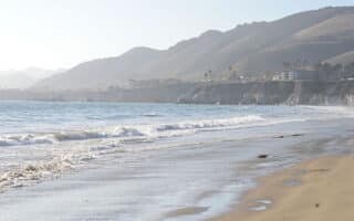
There is some spectacular beach running on California's central coast. Pismo Beach, Avila Beach, and Morro Bay feature miles of rugged, undeveloped beach, with reliably firm, compact sand near low tide.
San Luis Obispo is an attractive town on the central coast, 11 miles inland from the Pacific. Pleasant running downtown in numerous historic districts, and scenic but hilly running in the numerous hills and open spaces in town and right nearby.
Wonderfully scenic running in the hills in and around SLO. Poly Canyon trails are a favorite. Rugged trails around Bishops Peak and Irish Hills Preserve. Flatter options in the Laguna Lake Open Space. For a hilly road run, see our route just behind Cal Poly.
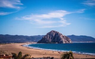
One of our favorite running spots on the central California coast. There's something for everyone here: gorgeous beach running, a coastal road/path, scenic and challenging trail running in the hills above the bay, and some decent running in town.
You might go to San Simeon to visit the Hearst Castle, but there's some lovely running in this area. Our favorite spot is trails of the Fiscalini Ranch Preserve. Also good running in San Simon State Park, and some sections of Highway 1.
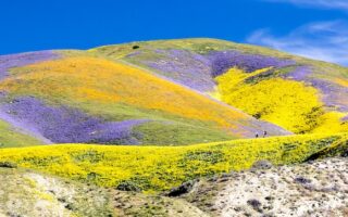
Huge & gorgeous area 90 minutes from San Luis Obispo is a worth-it destination run. Known for white alkali flats of Soda Lake, Painted Rock, vast open grasslands, and a broad plain rimmed by mountains. FAMOUS for wildflowers, in season!
Share your feedback on this route and see that of other Great Runs users. Click on the image icon to upload a photo. And please let us know if there are notes or changes we should incorporate!

Review or Comment on This Route/Share a Photo!
Share your feedback on this route and see that of other Great Runs users. Click on the image icon to upload a photo. And please let us know if there are notes or changes we should incorporate!