Korčula is a long island known for its sandy beaches, vineyards, and olive groves. A good part of the interior is dense forest. There’s some nice waterfront running on the island’s namesake village, and Vela Luka.
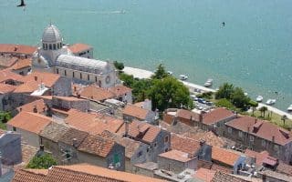
Korčula. ~4.7 km along the water.MAP. Attractive older village on the island’s northeastern end. We recommend exploring the pedestrianized older center on foot, and then enjoying the waterfront road/path. From the center, head east around the Uvala Luka bay for ~3 km, or west to Medvinjak Beach for 1.5 km.
For more and some to get the heart rate going, there are narrow, mainly car-free roads and paths above the town leading to the Forteca Svetog Vlaha (fortress) and to Naplov — a park/viewpoint.
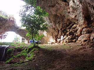
Kočje Nature Preserve. Inland nature preserve located in a dense pine forest. Several km of trails that are nice for running. Good shade option on a hot day! There’s a kiosk at the preserve’s entrance with a map.
Vela Spila Archaeological Site. Creative Commons.Vela Luka Waterfront. Google Street View
Vela Luka. This is an attractive, small town on the western side of Korčula, known for its wide bay, numerous indented coves, historic sites, and Hom mountain, which looms above. Some great running options:
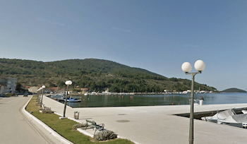
Waterfront. There’s a lovely road/path along the water, fairly free of traffic, that makes for a ~4 km flat out and back with some nice views. Just west of town, there’s work going on along Bobovišća, which we anticipate could eventually add to the route. MAP
Run to the Summit of Mt. Hom. A challenging run/hike to the 360m summit of this mountain which sits above the southern end of Vela Luka. There are two options: the shorter but steeper path, ascending 320m over 2.2 km, and the road, which climbs 360m over 5.8 km. Mix and match the two! Good views from the summit. PATH MAP ROAD MAP
Historic sites north of town. North of Vela Luka and toward the northern coast is a series quiet paths and trails that lead to numerous archaeological sites and other historic sites. There are some mapped walks/hikes that can be done in this area.
Korčula is a long island known for its sandy beaches, vineyards, and olive groves. A good part of the interior is dense forest. There’s some nice waterfront running on the island’s namesake village, and Vela Luka.
Korčula. ~4.7 km along the water.MAP. Attractive older village on the island’s northeastern end. We recommend exploring the pedestrianized older center on foot, and then enjoying the waterfront road/path. From the center, head east around the Uvala Luka bay for ~3 km, or west to Medvinjak Beach for 1.5 km.
For more and some to get the heart rate going, there are narrow, mainly car-free roads and paths above the town leading to the Forteca Svetog Vlaha (fortress) and to Naplov — a park/viewpoint.
Kočje Nature Preserve. Inland nature preserve located in a dense pine forest. Several km of trails that are nice for running. Good shade option on a hot day! There’s a kiosk at the preserve’s entrance with a map.
Vela Spila Archaeological Site. Creative Commons.Vela Luka Waterfront. Google Street View
Vela Luka. This is an attractive, small town on the western side of Korčula, known for its wide bay, numerous indented coves, historic sites, and Hom mountain, which looms above. Some great running options:
Waterfront. There’s a lovely road/path along the water, fairly free of traffic, that makes for a ~4 km flat out and back with some nice views. Just west of town, there’s work going on along Bobovišća, which we anticipate could eventually add to the route. MAP
Run to the Summit of Mt. Hom. A challenging run/hike to the 360m summit of this mountain which sits above the southern end of Vela Luka. There are two options: the shorter but steeper path, ascending 320m over 2.2 km, and the road, which climbs 360m over 5.8 km. Mix and match the two! Good views from the summit. PATH MAP ROAD MAP
Historic sites north of town. North of Vela Luka and toward the northern coast is a series quiet paths and trails that lead to numerous archaeological sites and other historic sites. There are some mapped walks/hikes that can be done in this area.
One of the most scenic waterfront runs on the Dalmatian Coast! Includes a loop of Park-šuma Komrčar, the peninsula, and the a path to Petrac Town Beach. Nearly all on a dedicated path, with great views.
Scenic waterfront run that includes a 2 km loop around the peninsular Old Town and then 5 km along the harbor and around several marinas to Puntamika. Some good add-on options.
Some of the most scenic and varied running options along the Dalmatian coast. We've mapped ~18 km along mainly dedicated waterfront paths, with great views of St. Anthony's Channel, the Adriatic, two famous fortresses, and lakes!
Three great routes in Croatia's second largest city: Up to 7 km along the waterfront; a lovely loop of Marjan Forest Park; and two mapped 'runseeing' tours of the historic old town and area parks.
Some nice waterfront running on Brač, an island known for its pebble beaches. The seafront promenade in Bol is our favorite, but there are good options in Sumartin, Postira-Splitzka, Supetar, & Sutivan.
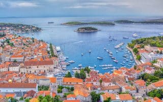
On this picturesque island, we've mapped lovely waterfront routes in Hvar, Stari Grad, and Vrboska. Runners can also enjoy some quiet interior roads, passing farms & vineyards.
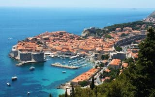
We've created 8+ great runs in this walled city and UNESCO Hertage site: waterfront promenades, a 'runseeing' tour of Old Town, forest parks, river paths, hill running above the city, and a loop around Lokrum Island.
Share your feedback on this route and see that of other Great Runs users. Click on the image icon to upload a photo. And please let us know if there are notes or changes we should incorporate!


Review or Comment on This Route/Share a Photo!
Share your feedback on this route and see that of other Great Runs users. Click on the image icon to upload a photo. And please let us know if there are notes or changes we should incorporate!