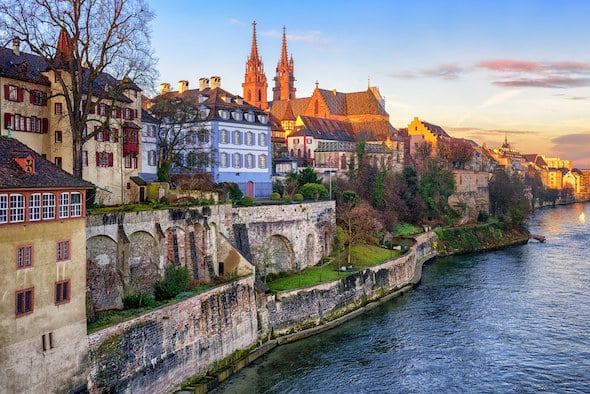
This is a ‘runseeing’ tour of Basel’s pretty and well-preserved Old Town. The historic section of Basel is actually in two sections: the Altstadt Grossbasel (Greater Basel) on the south side of the Rhine, and Altstadt Kleinbasel (Lesser Basel) on the north side. It’s challenging to map a specific route of the Old Town because of the maze of relatively short, narrow streets — so use our map as an anchor to create your own route. As a guideline, in Grossbasel, it’s ~1.6 km north-south between the University of Basel and the Basel Historical Museum and ~0.8 km inside of Steinengraben to one of the two historic bridges (Middle Bridge and Wettsteinbrücke). In Kleinbasel, the older section is ~1 km north-south from Feldbergstrasse to Wettsteinbrücke, and east from the river to the Convention Center (Messe), staying inside of the A3. Five walking tours around Basel’s historic centre, each marked with blue symbols, are a good way to explore the old town on foot.
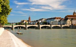
Mapped Route: Start at Spalentor, the historical gateway in Grossbasel. Run east through the old town, using Heuberg, passing Labyrinthplatz and the Toy Museum. Make your way east to De-Wette Park, and then use the Elisabethenstrasse, more of a main road, past the Basel Historical Museum and the Carnival Fountain (Tinguely Brunnen), bearing LEFT past the KunstMuseum onto Freie Str., heading south to the University of Basel, passing the Marktplatz, the main square (or, use Rittergasse to pass the famous Basel Minster Cathedral). Cross the Middle Bridge over to Kleinbasel, then doing a short section south along the Rhine path, past several museums. Turn RIGHT on Klingentalgraben, and then do a jaunt for ~0.8 km south along any of the streets through Kleinbasel, such as Claragraben. Cross back over the Wettsteinbrücke into Grossbasel. At the Kunsthalle Basel/Tinguely Brunnen, bear RIGHT on Steinenberg, and then onto Leonhardsgraben to return to the start.
This is a ‘runseeing’ tour of Basel’s pretty and well-preserved Old Town. The historic section of Basel is actually in two sections: the Altstadt Grossbasel (Greater Basel) on the south side of the Rhine, and Altstadt Kleinbasel (Lesser Basel) on the north side. It’s challenging to map a specific route of the Old Town because of the maze of relatively short, narrow streets — so use our map as an anchor to create your own route. As a guideline, in Grossbasel, it’s ~1.6 km north-south between the University of Basel and the Basel Historical Museum and ~0.8 km inside of Steinengraben to one of the two historic bridges (Middle Bridge and Wettsteinbrücke). In Kleinbasel, the older section is ~1 km north-south from Feldbergstrasse to Wettsteinbrücke, and east from the river to the Convention Center (Messe), staying inside of the A3. Five walking tours around Basel’s historic centre, each marked with blue symbols, are a good way to explore the old town on foot.
Mapped Route: Start at Spalentor, the historical gateway in Grossbasel. Run east through the old town, using Heuberg, passing Labyrinthplatz and the Toy Museum. Make your way east to De-Wette Park, and then use the Elisabethenstrasse, more of a main road, past the Basel Historical Museum and the Carnival Fountain (Tinguely Brunnen), bearing LEFT past the KunstMuseum onto Freie Str., heading south to the University of Basel, passing the Marktplatz, the main square (or, use Rittergasse to pass the famous Basel Minster Cathedral). Cross the Middle Bridge over to Kleinbasel, then doing a short section south along the Rhine path, past several museums. Turn RIGHT on Klingentalgraben, and then do a jaunt for ~0.8 km south along any of the streets through Kleinbasel, such as Claragraben. Cross back over the Wettsteinbrücke into Grossbasel. At the Kunsthalle Basel/Tinguely Brunnen, bear RIGHT on Steinenberg, and then onto Leonhardsgraben to return to the start.


Review or Comment on This Route/Share a Photo!
Share your feedback on this route and see that of other Great Runs users. Click on the image icon to upload a photo. And please let us know if there are notes or changes we should incorporate!