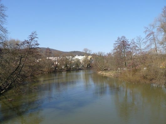
There’s a nice network of pedestrian & cycle paths along the Svratka River, which flows south of the historic centre. We’ve mapped two separate routes, which can be combined for many km of off-road awesomness! Overall, we prefer the southern loop.
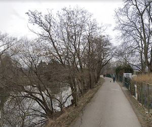
South Loop. This makes for a nice 6.4 km loop, incorporating paths on both banks of the river. There are nice water views for much of the route. Starting at the Vídeňská Bridge, head south along the west bank of the river, on a paved cycle path for 3 km to a pedestrian bridge near the KŠÍROVKA sports complex. Cross to the eastern side, and run back along the cycle path to the bridge.
Google Street View
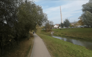
North Direction. The paths headed north are a little less seamless, but still worth running! There are a couple of road sections. We’ve mapped up to 7 km north to Brno-Komín. From the Vídeňská Bridge, run for 0.8 km along Kamenná on the south/west bank, and then onto the cycle path for a 50m climb over 0.5 km. Continue north to the Anthropos Archeological Museum (3 km mark). North of there, it’s a combination path & road along the river for up to another 3.5 km to the Sportovní sports complex.
There’s a nice network of pedestrian & cycle paths along the Svratka River, which flows south of the historic centre. We’ve mapped two separate routes, which can be combined for many km of off-road awesomness! Overall, we prefer the southern loop.
South Loop. This makes for a nice 6.4 km loop, incorporating paths on both banks of the river. There are nice water views for much of the route. Starting at the Vídeňská Bridge, head south along the west bank of the river, on a paved cycle path for 3 km to a pedestrian bridge near the KŠÍROVKA sports complex. Cross to the eastern side, and run back along the cycle path to the bridge.
Google Street View
North Direction. The paths headed north are a little less seamless, but still worth running! There are a couple of road sections. We’ve mapped up to 7 km north to Brno-Komín. From the Vídeňská Bridge, run for 0.8 km along Kamenná on the south/west bank, and then onto the cycle path for a 50m climb over 0.5 km. Continue north to the Anthropos Archeological Museum (3 km mark). North of there, it’s a combination path & road along the river for up to another 3.5 km to the Sportovní sports complex.
Scroll Down For Route Maps
Essentials
Up to 10 km of nearly continuous path. We've mapped a 6.4 southern loop, and 7 km headed north
Flat, except for one short, steep hill headed north
One of our favorite 'runseeing' tours in Europe. Explore the largely pedestrianized old town, Lužánky Park, the grounds of Špilberk Castle, and the hilltop Cathedral of St. Peter and Paul.
Many km of running possible along the narrow Svitava River in the eastern part of Brno. Combination of dedicated path & small road. Water views and a good option for a longer off-road run.
Hilly running in the leafy Wilson Forest Park is rewarded by great city views! Combine with Kraví hora Park for a nice ~5.4 km loop, or make it even longer by using the connector path to Špilberk Castle.
Some decent running on waterfront and forested paths at this popular swimming & boating site. At Veveří Castle, enjoy some quiet farm roads, or trail running across the pedestrian bridge.
Popular recreation spot at the eastern edge of Brno features many km of mainly wooded trails for running. Some easier multi-use paths and some narrower, hillier trails.
Enjoy a wooded trail run in one of Brno's forest parks. There are several significantly sized ones located in the metro area. We've listed some of our favorites. Create your own route! Many of these parks are fairly hilly.
Share your feedback on this route and see that of other Great Runs users. Click on the image icon to upload a photo. And please let us know if there are notes or changes we should incorporate!
Subscribe
0 Comments
Oldest
Newest
Inline Feedbacks
View all comments
Essentials
Up to 10 km of nearly continuous path. We've mapped a 6.4 southern loop, and 7 km headed north
Flat, except for one short, steep hill headed north


Review or Comment on This Route/Share a Photo!
Share your feedback on this route and see that of other Great Runs users. Click on the image icon to upload a photo. And please let us know if there are notes or changes we should incorporate!