Categories:
Stamford and Greenwich are both gateways to New York City and also the location of many financial firms and hedge funds. The area is home to many high-end residences and pastoral roads. West of I-95, there are pretty, low-traffic roads that are pleasant for rural running. There’s also excellent running in Norwalk, along the waterfront. Some of the best places to run in Stamford and Greenwich include:
Parks and Points. The East Side of Stamford is the best area to run. There are numerous spots that can be run individually or strung together. From WWE Headquarters just off Rt. 1, run on Weed Ave. for 1 mile to Cove Island. A loop around the Island is ~ 1 mile. Then it’s about 1 mile west to Cummings Park, which at 79 acres has a boardwalk and fishing pier. Turn around here for a ~6-7 mile run. Or add-on the 2 miles down to Shippan Point. This area has lovely homes and good water views at the point. MAP
Norwalk Waterfront. Just 8 miles north of Stamford, there is very nice running on the Norwalk waterfront. A couple of options: From the Norwalk Historical Society, it’s 1.9 miles along mostly dedicated paths to Liberty Point. MAP. On the western side, there’s a nice ~2 mile loop incorporating Mathews Park and Oyster Shell Park.
Waveny Park. Located in New Canaan, the 250-acre Waveny Park contains approximately 3.5 miles of trails for running. There are lots of other facilities: fields, picnic area, swimming pool, and lots of open area. Also a Performing Arts Center, The Carriage Barn, Community Center, The Waveny Lodge, and Platform Tennis Courts.
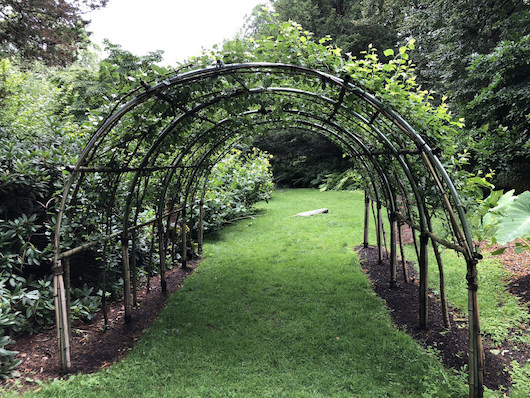
Bartlett Arboretum and Gardens. Wonderful area with 12 gardens and miles of paths for walking. Free admission. Gentle running OK on the trails. Trail Map.
Mianus River Park. This 400-acre park straddling Stamford and Greenwich has miles of trails that are great for running. There are woods, fields, and rolling hills. Numerous loop options, with the largest being the Yellow Loop — 4.5 miles with 356 feet of elevation gain. Trail Map
Babcock Preserve. 300 acres of woodlands, stretching between North Street and Lake Avenue in Greenwich. There are some lovely, wooded trails ranging in length from 1 to 3.5 miles. Access and parking is off North Street about .5 mile north of the Merritt Parkway.
Old Greenwich: Greenwich Point Beach and Tod’s Point. This is probably the prettiest run in the area. From Old Greenwich, run on Shore Rd. to Greenwich Point Beach, and along the perimeter road to Greenwich Point and over to Tod’s Point. A loop of the whole island is 4+ miles. There are some sandy paths on the eastern side near Greenwich Point. NOTE: $7 walk-in fee and $35 for parking. MAP
Greenwich: Bruce Park & Waterfront. 5 miles, 180 foot gain. Just east of Old Greenwhich, we’ve mapped a lovely 5-miler combining Bruce Park, Indian Harbor, and Grass Island. Start in Bruce Park, a classic older park featuring paths, fields, and ponds, and other recreational facilities. Continue west of the park on Davis Ave., and then take Indian Harbor Dr. (caution: no sidewalk), RIGHT on Oneida Dr. and LEFT on Steamboat Rd. to the water at Rocky Neck Point. This stretch Double back, to Roger Sherman Park. Here, there’s an optional 1 mile add-on to Grass Island, which requires a slightly unpleasant crossing of I-95 to get to Shore Rd., which takes you to Grass Island. ROUTE MAP

Comment on this Route/Share a Photo!
Share your feedback on this route and see that of other Great Runs users. Click on the image icon to upload a photo. And please let us know if there are notes or changes we should incorporate!