The paths along the Connecticut River are among the most popular places to run in Springfield. There are several sections, unfortunately not contiguous or well-connected. The two best sections are the The Connecticut River Walk and Bikeway, accessible from downtown Springfield, and a section in Agawam, just south of town. TRAIL MAP
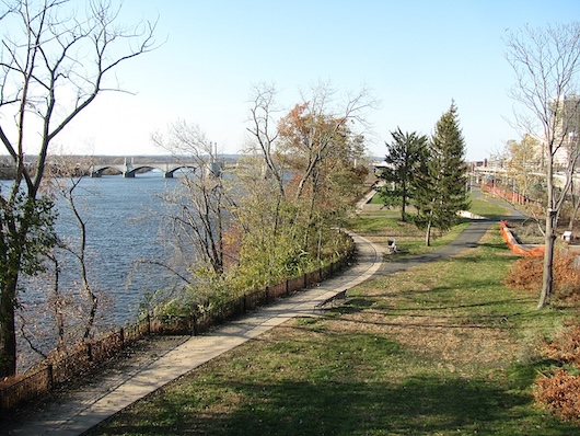
Connecticut River Walk and Bikeway. This paved multi-use path follows the east bank of the Connecticut River for 3.7 miles, from Mason Ave. in the north to just south of the National Basketball Hall of Fame. There are some nice views of the river, Springfield’s skyline, and the Holyoke and Mount Tom mountain ranges. The best access from downtown is to use the (not very pleasant) underpass off State St. or Union St. Note: Unfortunately, and curiously, there’s a ~1 mile section north of the N End Bridge (West St.) where a wall blocks views of the river.
- Add-On: Can catch part of our Springfield History & Homes tour.
Agawam Section. Just south of downtown, a paved multi-use trail runs along the western bank of the Connecticut River for 1.7 miles, paralleling River Rd. There are nice water views. The path runs from the intersection of River Rd. & School St. south to Borgatti Park.


Review or Comment on This Route/Share a Photo!
Share your feedback on this route and see that of other Great Runs users. Click on the image icon to upload a photo. And please let us know if there are notes or changes we should incorporate!