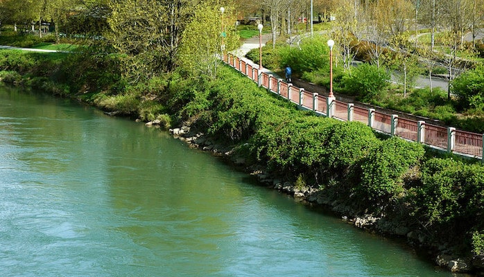
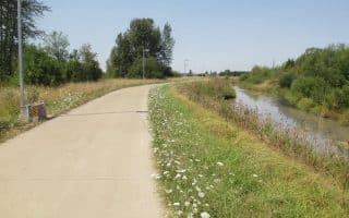
Known more commonly as the Willamette River Trail, the Ruth Bascom Riverbank Trail System is the most accessible and popular running route in Eugene. This paved, multi-use path connects Eugene and Springfield with over 14 miles of waterfront running. The attached map from Eugene Parks shows how the trail segments are divided: from the Greenway Ped/Bike Bridge, the East and West Bank Paths head for 2 miles north, while the North and South Bank Paths head southeast for 5 and 4 miles, respectively. Pedestrian/bike bridges scattered at strategic intervals make various loop options possible. The longest loop (from the Owasso to the Knickerbocker Bridge) is just under 12 miles. Runners will find connections to various other paths and parks throughout town. Highlights are the Whilamut Natural Area/Alton Baker Park, which connects with Pre’s Trail along the Canoe Canal, and the Skinner Butte Lookout on the south side of the river.
Don Hankins
Features:
Categories:
Scroll Down For Route Maps
Essentials
- Various loop options of up to 14+ miles
- 244 feet
- Anywhere along the river
- Depends on start. The Greenway Pedestrian/Bike Bridge is 2 miles from downtown
Current Weather & Forecast

Eugene, US
9:53 pm,
Jul 13, 2026
L: 19°
H: 19°
Daily ForecastHourly Forecast
Tomorrow
2:00 pm
19° / 33°°C
0 mm
0%
17 mph
78 %
1018 mb
0 mm/h
Wednesday
2:00 pm
21° / 32°°C
0 mm
0%
12 mph
92 %
1015 mb
0 mm/h
Thursday
2:00 pm
20° / 25°°C
0 mm
0%
14 mph
73 %
1016 mb
0 mm/h
Friday
2:00 pm
15° / 27°°C
0 mm
0%
9 mph
76 %
1019 mb
0 mm/h
Saturday
2:00 pm
16° / 28°°C
1 mm
100%
14 mph
95 %
1015 mb
0 mm/h
Today
11:00 pm
21° / 22°°C
0 mm
0%
9 mph
67 %
1018 mb
0 mm/h
Tomorrow
2:00 am
19° / 21°°C
0 mm
0%
10 mph
71 %
1018 mb
0 mm/h
Tomorrow
5:00 am
23° / 23°°C
0 mm
0%
11 mph
78 %
1018 mb
0 mm/h
Tomorrow
8:00 am
30° / 30°°C
0 mm
0%
16 mph
68 %
1017 mb
0 mm/h
Tomorrow
11:00 am
33° / 33°°C
0 mm
0%
17 mph
57 %
1016 mb
0 mm/h
Tomorrow
2:00 pm
33° / 33°°C
0 mm
0%
14 mph
62 %
1015 mb
0 mm/h
Tomorrow
5:00 pm
29° / 29°°C
0 mm
0%
10 mph
77 %
1014 mb
0 mm/h
Other Routes in Eugene, OR
A runner's pilgrimage in Tracktown USA. Scenic 4-mile trail celebrates the legacy of Olympian and Oregon track legend Steve Prefontaine. Follow the wood chips through woods, tall grasses, and along a canal. Add on with trails in Alston Baker Park.
The Adidas Oregon Trail (aka the Amazon Trail) is a flat one mile path along the Amazon Creek, which connects with the lovely 3.5-mile Rexius Trail. Bonus: lit for night running.

One of the top hiking spots in Eugene, the hilly trail to Spencer Butte rewards with an incredible view overlooking the city and Willamette Valley. A multitude of trail running options, mostly quite challenging & hilly.

Hendricks Park is the oldest park in Eugene, featuring incredible rhododendron gardens and miles of paved and dirt paths, including access to the 12 mile Ridgeline Trail.
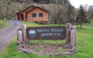
This stunning arboretum just a few minutes from town is brimming with paths, from easy rambles to steep climbs up the mountain. A favorite route is an 8 mile loop around the base of Pisgah.
An asphalt and concrete path reaching 6 miles from Westmoreland City Park to Meadowlark Prairie Reserve. The nicest part is the west end, where runners can extend their run to Fern Ridge Reservoir.
Springfield’s Dorris Ranch is a “Living History Farm” and one of the most popular access points for the 4 mile paved Middle Fork bike path, which runs east to Clearwater Park. Numerous other paths in the Springfield area.
Some of the best trail running in Oregon is on the 24+ mile McKenzie River Trail, about an hour’s drive from Eugene. Relatively flat and very scenic.

The best neighborhoods for running in Eugene include Laurel Hill, Amazon, and the area surrounding the University of Oregon. Mostly DIY options on grid-like streets. Try to persuade U of Oregon folks to reopen Hayward Field to the public!
User Ratings
Leave A Review or Comment
Review or Comment on This Route/Share a Photo!
Share your feedback on this route and see that of other Great Runs users. Click on the image icon to upload a photo. And please let us know if there are notes or changes we should incorporate!