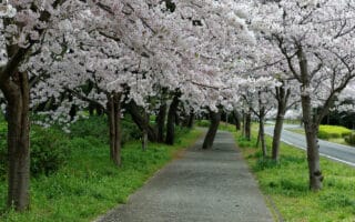
Mt. Imori: “Imori Yama” is a modest and accessible mountain on the west end of Fukuoka. While there are a few steep and technical sections, most of the 4.5 km out and back is runnable. Runners who go in June will be greeted by a beautiful stretch of hydrangeas. TRAIL INFO.
Mt. Wakasugi: Mt. Wakasugi is located on the east edge of the city near Sue. There’s a popular camping area near the summit, a number of temples, and some interesting hiking trails. The concrete path from the Wakasugi Rakuen campground to the Shinto Shrine runs through some beautiful forest. Keep in mind it can get slippery! ROUTE MAP. TRAIL INFO.
Mt. Korasan: Mt. Korasan is located near Kurume, just south of Fukuoka. There are a number of trails around the mountain leading to the Kora Taisha shrine. There are lots of stairs to climb, but some great views and lovely gardens. The Kurumeshinrintsutsuji Park is especially noteworthy. ROUTE MAP.
Mt. Abura: Mt. Abura is one of the closest recreation areas to Fukuoka, and it has an expansive network of trails. One popular trails starts near the Aburayama Greenland Golf Course and heads up the forested slopes to a series of lookouts. TRAIL INFO.
Mt. Ogi: Mt. Ogi — situated between Onojo and Dazaifu — has some splendid trails that are mostly runnable. There is a 6 mile loop around the mountain, as well as some easier out and back options. ROUTE MAP.


Review or Comment on This Route/Share a Photo!
Share your feedback on this route and see that of other Great Runs users. Click on the image icon to upload a photo. And please let us know if there are notes or changes we should incorporate!