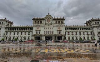
Of our two main routes through the central part of Guatemala City, this route is focused on the section headed south from the Centro Civico along Avenida La Reforma & Parque Las Americas. It’s up to 6.5 km one-way, and can be combined with our northern route through the historical centre.
Start at the Tourist Office in the Centro Civico. You might be able to sneak into the Estadio for a couple of laps around the running track. Head south along 10A Avenida for 1.5 km, which turns into Avenida La Reforma at the small Botanical Garden. Continue south along La Reforma, a wide, grand avenue with lots of space for running! Pass the Zona Vica hotel district, Plaza de la Republica, Torre del Reformador (steel tower), numerous apartment buildings, sculptures, and art displays. It’s 2.5 along La Reforma to the Plaza Obelisco (Obelisk Square), which is a major intersection point of the city.
Parque Americas: Google Street View
From Plaza Obelisco, continue south along the Avenida Las Americas, which has a pleasant green linear park/bike along its middle. This section is 2.5 km, ending at the Juan Pablo II Monument. It also passes just to the east of the La Aurora (Guatemala City) International Airport.
Shorter Options: Since this would be a 12k out and back, you can shorten the route by focusing on the Av. La Reforma or Parque Las Americas sections.
Longer Options: Combine with our northern section from Centro Civico through the Historic Centre to the Relief Map. This can be a combined route of 20 km!
PRO TIP: Huge, gorgeous Christmas Tree at Plaza Obelisco, in season!
Scroll Down For Route Maps
Essentials
Up to 6.5 km one-way. Options for shorter & longer!
35m (115 feet) one-way, headed south
Tourist Office in Centro Civico. Plaza Obelisco is another popular start point
Subway: Estación Plaza Barrios for Centro Civico or Estación Acueducto for Plaza Obelisco
Of our two main routes through downtown Guatemala City, this 'runseeing tour' heads north from the Centro Civico through the historic centre, then through Jocotenango Park to the Relief Map. Can combine with southern route.
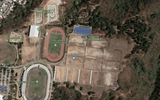
The largest park in the city and a decent place for a run in Zone 7. There are sports fields, and an excellent running track. It's a ~3.2 km loop around the park perimeter.
The Universidad de San Carlos campus is one of the better off-road spots in Guatemala City for a run. Pleasant pedestrian paths, small parks, and a running track. Av. Petapa just to the east also runnable.
It's possible to stitch together a quite pleasant ~5 mile run in the upscale Cayala district in Zone 16, combining Plaza Cayala, Blvd. Rafael Landivar, and the green median along Blvd. Vista Hermosa. Hilly!
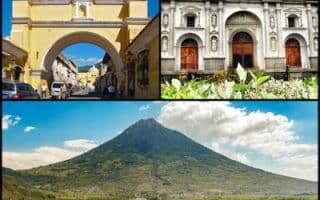
Just 30 km from Guatemala City, explore the historic streets of this UNESCO World Heritage site. Get the heart rate up & great views by running to the Hill of the Cross! Hilly & rugged trail running options just outside of town.
Share your feedback on this route and see that of other Great Runs users. Click on the image icon to upload a photo. And please let us know if there are notes or changes we should incorporate!
Subscribe
0 Comments
Oldest
Newest
Inline Feedbacks
View all comments
Essentials
Up to 6.5 km one-way. Options for shorter & longer!
35m (115 feet) one-way, headed south
Tourist Office in Centro Civico. Plaza Obelisco is another popular start point
Subway: Estación Plaza Barrios for Centro Civico or Estación Acueducto for Plaza Obelisco


Review or Comment on This Route/Share a Photo!
Share your feedback on this route and see that of other Great Runs users. Click on the image icon to upload a photo. And please let us know if there are notes or changes we should incorporate!