This scenic and mostly dirt and crushed limestone path extends from Broad Ripple Village in the north to 30th Street south. It is best maintained in the middle third between 52nd and Michigan Road, the heart of the Butler campus and the most popular section of the Canal. The trail runs by 19th century bridges, a pedestrian bridge, the Museum of Art, Butler Campus, and other universities and parks. A stone marker, located at 52nd Street, shows many landmarks and the distances between.
Full Trail Info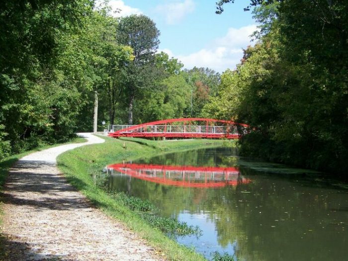
Features:
Categories:
Scroll Down For Route Maps
Essentials
- 3.45 miles one-way; 6.9 miles out-and-back
- 127 foot gain, one way
- South End: Indianapolis Museum of Art, Ruth Lilly Visitors Ctr. @ North Michigan Rd; North End: Broad Ripple Ave.
Current Weather & Forecast

Indianapolis, US
5:05 am,
Jul 10, 2026
L: 21°
H: 23°
Daily ForecastHourly Forecast
Today
5:00 pm
21° / 23°°C
0 mm
0%
8 mph
67 %
1019 mb
0 mm/h
Tomorrow
5:00 pm
16° / 27°°C
0 mm
0%
11 mph
75 %
1021 mb
0 mm/h
Sunday
5:00 pm
13° / 24°°C
0 mm
0%
11 mph
91 %
1023 mb
0 mm/h
Monday
5:00 pm
16° / 24°°C
0 mm
0%
14 mph
94 %
1024 mb
0 mm/h
Tuesday
5:00 pm
15° / 26°°C
0 mm
0%
11 mph
70 %
1025 mb
0 mm/h
Today
5:00 am
21° / 21°°C
0 mm
0%
8 mph
66 %
1018 mb
0 mm/h
Today
8:00 am
22° / 23°°C
0 mm
0%
8 mph
62 %
1018 mb
0 mm/h
Today
11:00 am
23° / 25°°C
0 mm
0%
8 mph
53 %
1018 mb
0 mm/h
Today
2:00 pm
22° / 22°°C
0 mm
0%
7 mph
57 %
1018 mb
0 mm/h
Today
5:00 pm
18° / 18°°C
0 mm
0%
4 mph
67 %
1019 mb
0 mm/h
Today
8:00 pm
17° / 17°°C
0 mm
0%
3 mph
70 %
1019 mb
0 mm/h
Today
11:00 pm
16° / 16°°C
0 mm
0%
5 mph
73 %
1020 mb
0 mm/h
Other Routes in Indianapolis, IN


A terrific option for running in the heart of Indianapolis. The paved multi-use path runs for up to 7 miles along the White River from Raymond St. north to Riverside Park. Parks, skyline & water views, and some key Indy sites.
A popular race route, but it is also a great "Heart of the City" run. There are 2 routes: a 3.3 and a 5 mile loop.

One of the best downtown spots to run, no matter the time of day. It's safe, quiet, and uninterrupted by traffic for an almost 2 mile loop.

A ten-mile pedestrian and cycle friendly trail connecting six cultural districts in downtown Indianapolis. Good connections to other multi-use trails.
A popular paved trail that runs along Fall Creek. Starts at Kessler Park, ~2.5 miles north of downtown, and runs 9.5 northeast to Skiles Test Nature Park. Water views as you pass century-old bridges and established neighborhoods.

A popular running spot and one of the largest metropolitan green spaces in the nation. There are 10 miles of trails and certified road courses of 5K, 8K, and 10K. Combination of wooded & waterside trails, with some rolling hills.

Run along the inaugural 'rails to trails' trail! This paved, multi-use path stretches from near downtown, north for 25+ miles to Sheridian, with numerous connections to other area trails. There are several 'sections' of the trail.

A new addition to the Indy running scene. This 3.7 mile trail follows Pogue's Run (creek), just east of I-70, for 3.7 miles. Mix of residential, parks, and wetlands. Connect to the Monon Traiil @ 10th St.

There are some lovely residential neighborhoods for running just north of downtown. Start in Meridian Hills, using the spectacular North Meridian St. as an anchor, and work your way north to Nora and Carmel.
Explore the eastern and southern edges of the city with the Pleasant Run Trail. The south end is at Garfield Park, the north end is Ellenberger Park.

Formerly a military installation, Fort Ben, as it's called, is now a state park and nature preserve. There are several trails to choose from, however, none of the individual trails are more than three miles.
User Ratings
Leave A Review or Comment
Review or Comment on This Route/Share a Photo!
Share your feedback on this route and see that of other Great Runs users. Click on the image icon to upload a photo. And please let us know if there are notes or changes we should incorporate!