
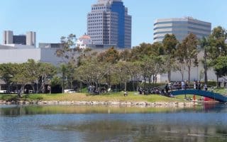
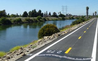
OK, so this won’t win the award for scenery, but if you want a long, flat, paved, and exposed running route, this is a good bet. The Los Angeles River Bike Trail runs from Long Beach all the way to Los Angeles, some 20 miles, with additional spurs in the L.A. area around the Glendale Narrows. The Long Beach portion of the path, known as LARIO, starts at the Shoreline Pedestrian Path at the mouth of the river, and continues upstream, on the eastern side of the river to the Imperial Highway. Much of the channel bed is dry and the views are mainly of cement and power lines…but there are continued efforts to improve the trail and make it more scenic and recreation friendly.
We’ve mapped a 10.3 mile section of the trail, from Ocean Blvd. in Long Beach, north to the I-105. Nicest sections: Wrigley Greenbelt, from W. Willow St. to I-405 (1.3 miles); and just north of there, ~3 miles in Los Cerritos, from the Dominguez Gap Wetlands (access: N Virginia Vista) through DeForest Park. Some spots of green and nice landscaping. Key Distances, heading north from Long Beach (distances are cumulative):
1 mile: W. Anaheim St.
1.6 miles: Pacific Coast Highway
2.5 miles: W. Willow St.
4 miles: I-405 (Dominguez Gap Wetlands just north of there)
6.5 miles: DeForest Park
7.8 miles: Highway 91
10.3 miles: I-105


Review or Comment on This Route/Share a Photo!
Share your feedback on this route and see that of other Great Runs users. Click on the image icon to upload a photo. And please let us know if there are notes or changes we should incorporate!