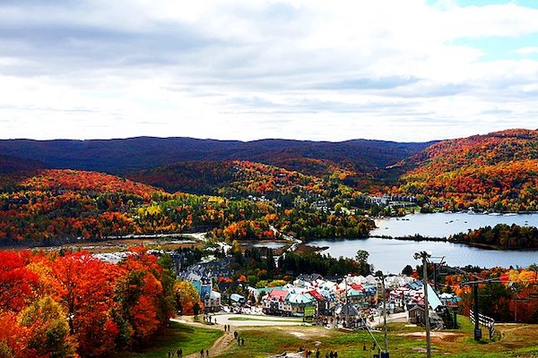
The Mont Tremblant area is one of the most popular visitor spots in the Laurentians, known for its eponymous mountain, and gateway to the huge National Park. It’s also a center for all sorts of outdoor recreation: downhill skiing on Mont Tremblant, nordic skiing, biking, golf, and water related activities on the area’s hundreds of lakes. There’s a cute, faux ‘town center’, great dining options, and other attractions, from a casino to a car racing track.
For running, there are some good options. Trail runners will find a huge number of options in Mont Tremblant National Park (see our separate post), and, in summer & fall, trails on Mont Tremblant, which are lift-serviced. Best options for road running are:
Pedestrian Village. There’s a pleasant pedestrian village with numerous shops, restaurants, and nice paths for walking/running. See this MAP for more info.
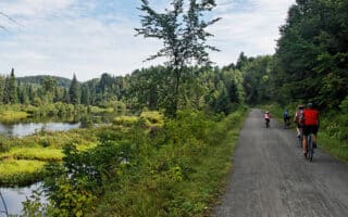
Devil’s River Loop. A 6.7 km paved multi-use path starts near the village center and makes for a nice area tour. Includes 2 km along Devil’s River. Longer option extends to Lac Mercier to connect with the P’tit Train du Nord trail (see below). MAP
Lac Mercier Extension. From the route above, you can extend to Lac Mercier to connect with the P’tit Train du Nord trail. At the 4.4 km mark, rather than completing the loop, continue on the path, crossing the rivrer, for up to 4 km to Lac Mercier beach, and then on the P’tit Train du Nord trail for another 3 km along Lac Mercier (and still further on the P’tit Train trail if you like!). MAP
Chemin Duplessis. For a longer road run, the best bet is Chemin Duplessis, which skirts edge of Mont Tremblant. We’ve mapped the nearly 11 km that has a decent shoulder. The first 4 km from the village are flat, then starts a steady climb. MAP
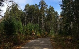
P’tit Train du Nord. A section of this 230 km multi-use path passes just to the south of Tremblant. Pick it up at Lac Mercier or just south of the Tourist Center at the Golf Club. A paved section runs for nearly 20 km from Lac (lake) Mercier to Lac Carré. TRAIL MAP (click on section near Tremblant). OUR ROUTE
Mont Tremblant Trails. In summer and fall, there’s some excellent trail running on Mont Tremblant’s hiking trails. This trail map has excellent information on the trails, including difficulty ratings and distances.
The Mont Tremblant area is one of the most popular visitor spots in the Laurentians, known for its eponymous mountain, and gateway to the huge National Park. It’s also a center for all sorts of outdoor recreation: downhill skiing on Mont Tremblant, nordic skiing, biking, golf, and water related activities on the area’s hundreds of lakes. There’s a cute, faux ‘town center’, great dining options, and other attractions, from a casino to a car racing track.
For running, there are some good options. Trail runners will find a huge number of options in Mont Tremblant National Park (see our separate post), and, in summer & fall, trails on Mont Tremblant, which are lift-serviced. Best options for road running are:
Pedestrian Village. There’s a pleasant pedestrian village with numerous shops, restaurants, and nice paths for walking/running. See this MAP for more info.
Devil’s River Loop. A 6.7 km paved multi-use path starts near the village center and makes for a nice area tour. Includes 2 km along Devil’s River. Longer option extends to Lac Mercier to connect with the P’tit Train du Nord trail (see below). MAP
Lac Mercier Extension. From the route above, you can extend to Lac Mercier to connect with the P’tit Train du Nord trail. At the 4.4 km mark, rather than completing the loop, continue on the path, crossing the rivrer, for up to 4 km to Lac Mercier beach, and then on the P’tit Train du Nord trail for another 3 km along Lac Mercier (and still further on the P’tit Train trail if you like!). MAP
Chemin Duplessis. For a longer road run, the best bet is Chemin Duplessis, which skirts edge of Mont Tremblant. We’ve mapped the nearly 11 km that has a decent shoulder. The first 4 km from the village are flat, then starts a steady climb. MAP
P’tit Train du Nord. A section of this 230 km multi-use path passes just to the south of Tremblant. Pick it up at Lac Mercier or just south of the Tourist Center at the Golf Club. A paved section runs for nearly 20 km from Lac (lake) Mercier to Lac Carré. TRAIL MAP (click on section near Tremblant). OUR ROUTE
Mont Tremblant Trails. In summer and fall, there’s some excellent trail running on Mont Tremblant’s hiking trails. This trail map has excellent information on the trails, including difficulty ratings and distances.


Review or Comment on This Route/Share a Photo!
Share your feedback on this route and see that of other Great Runs users. Click on the image icon to upload a photo. And please let us know if there are notes or changes we should incorporate!