The paths along the Segura River form the heart of running in Murcia. In the central part of the city, there are a series of riverfront parks and gardens. Then, long-distance cycle paths extend east and west along the river. We’ve divided this route into three sections, each with a map.
Central River Loop
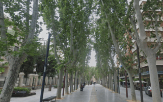
This is a terrific 5.6 km riverfront loop in central Murcia. There are paths on both sides of the river, and numerous bridges for crossing. Start at the historic Ponte Viejo. Head west, along the Paseo del Malecón — a historic 15th-century promenade that serves as a gateway to the Murcian “Huerta”, which are historic gardens. The path goes under the highway, and then through the palm-lined Murcia Río Garden. Run along the south side of the river, using the pedestrian Pasarela de Manterola bridge. The path is a wide sidewalk above the river along Av. Infante Juan Manuel. Head west for 1.4 km, then cross to the north bank using the Pasarela de Jorge Manrique pedestrian bridge. Then, run for 1.6 km back west along the north side, through a linear riverfront park between the Puente de la Fica and Ponte Viejo. There are additional paths in the Parque Vistabella and Jardín Chino.
River Paths Headed West
A paved cycle path continues west for up to 11 km to La Contraparada. It winds through mainly open, dry terrain along the narrow, and sometimes dry river. A good 8 km out & back is from the MU-33 Highway west to the Puente Peatonal.
River Paths Headed East
Bike Path Headed East. Google Street View
The cycle path also heads east of Puente de la Fica (bridge) for 13 km toward Beniel. It’s paved in parts and then more of a dirt road. Called Carril Salazar much of the way. It’s fairly open, dry terrain, passing some farms and scrubland.
The paths along the Segura River form the heart of running in Murcia. In the central part of the city, there are a series of riverfront parks and gardens. Then, long-distance cycle paths extend east and west along the river. We’ve divided this route into three sections, each with a map.
Central River Loop
This is a terrific 5.6 km riverfront loop in central Murcia. There are paths on both sides of the river, and numerous bridges for crossing. Start at the historic Ponte Viejo. Head west, along the Paseo del Malecón — a historic 15th-century promenade that serves as a gateway to the Murcian “Huerta”, which are historic gardens. The path goes under the highway, and then through the palm-lined Murcia Río Garden. Run along the south side of the river, using the pedestrian Pasarela de Manterola bridge. The path is a wide sidewalk above the river along Av. Infante Juan Manuel. Head west for 1.4 km, then cross to the north bank using the Pasarela de Jorge Manrique pedestrian bridge. Then, run for 1.6 km back west along the north side, through a linear riverfront park between the Puente de la Fica and Ponte Viejo. There are additional paths in the Parque Vistabella and Jardín Chino.
River Paths Headed West
A paved cycle path continues west for up to 11 km to La Contraparada. It winds through mainly open, dry terrain along the narrow, and sometimes dry river. A good 8 km out & back is from the MU-33 Highway west to the Puente Peatonal.
River Paths Headed East
Bike Path Headed East. Google Street View
The cycle path also heads east of Puente de la Fica (bridge) for 13 km toward Beniel. It’s paved in parts and then more of a dirt road. Called Carril Salazar much of the way. It’s fairly open, dry terrain, passing some farms and scrubland.
Scroll Down For Route Maps
Essentials
Main loop is 5.6 km (3.5 miles). You can also run for several km east and west along the river on a cycle path
A 'runseeing' tour of Murcia's historic center, which includes the Gran Via and several small parks. Use our mapped route as a guideline to create your own adventure!
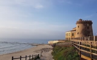
About 40 km east of Murcia, there are several scenic coastal routes along the Southern Costa Blanca. We've mapped routes in Torrevieja, Punta Prima, Oriheula, and Torre De La Horadada.
Share your feedback on this route and see that of other Great Runs users. Click on the image icon to upload a photo. And please let us know if there are notes or changes we should incorporate!
Subscribe
0 Comments
Oldest
Newest
Inline Feedbacks
View all comments
Essentials
Main loop is 5.6 km (3.5 miles). You can also run for several km east and west along the river on a cycle path


Review or Comment on This Route/Share a Photo!
Share your feedback on this route and see that of other Great Runs users. Click on the image icon to upload a photo. And please let us know if there are notes or changes we should incorporate!