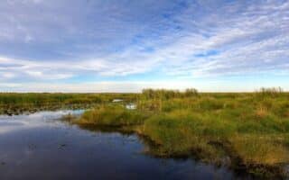
There’s nearly 20 miles of scenic running along Lake Pontchartrain, which is the second-largest saltwater lake in the United States. It’s almost all on dedicated waterfront paths. The lake is located at the north end of New Orleans, about 1 mile from City Park. The area has an interesting history. Pontchartrain Beach was home to an amusement park from 1929 to 1983, and If you’re looking for a path along the water, and Pontchartrain Park was one of the first suburban-style subdivisions developed by middle class African Americans during the Jim Crow era of racial segregation in Louisiana.
There are two ‘sections’ for running along Lake Pontchartrain, divided by Breakwater Park @ the 17th St. Canal: east along Lakeshore Drive, and west along the Lakefront Trail. NOTE: the lakeshore run is very open & exposed. Use caution in heat & storms!
Lakeshore Drive Promenade East to Pontchartrain Park
From Breakwater Park headed east, there’s a scenic waterfront promenade that runs along Lakeshore Dr. for 5.6 miles. It’s a wide waterfront path, with open water views the whole way. It’s also lit at night. There are a couple of short on-road sections at canal crossings. and an interior section around the Milneburg Lighthouse. The eastern 2 miles skirt the edge of the campuses of the University of New Orleans – East Campus and the Southern University at New Orleans. Also at the eastern end is access to Pontchartrain Park. It’s mainly a golf course, but you can do a ~2 mile loop around the park on perimeter roads.
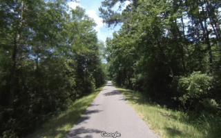
Lakefront Trail Headed West
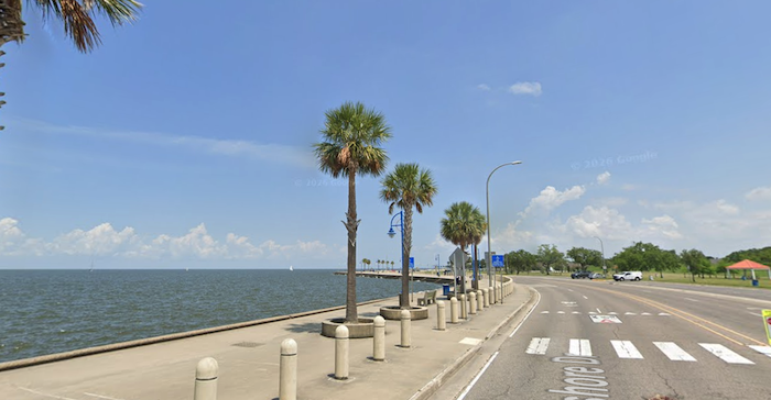
Lakefront Trail. Google Street View
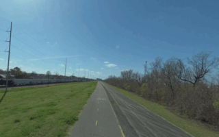
A paved multi-use path runs west from Breakwater Park for 10 miles west to Kenner. It’s a narrower path than the wide promenade along Lakeshore Dr., but it’s also quieter and more remote, being away from a major road. There are open views of the lake the whole way. You’ll cross the Lake Pontchartrain Causeway, Clearview Blvd., & Laketown. The west end of the trail is at the Duncan Canal in Kenner. There, you can continue on a Levee trail along the canal for ~2 miles south. NOTE: the west end of the trail and levee trail are good running options near Louis Armstrong Airport.
Add-Ons: City Park is 1 mile south of Lake Pontchartrain. Best access is Marconi Dr.
There’s nearly 20 miles of scenic running along Lake Pontchartrain, which is the second-largest saltwater lake in the United States. It’s almost all on dedicated waterfront paths. The lake is located at the north end of New Orleans, about 1 mile from City Park. The area has an interesting history. Pontchartrain Beach was home to an amusement park from 1929 to 1983, and If you’re looking for a path along the water, and Pontchartrain Park was one of the first suburban-style subdivisions developed by middle class African Americans during the Jim Crow era of racial segregation in Louisiana.
There are two ‘sections’ for running along Lake Pontchartrain, divided by Breakwater Park @ the 17th St. Canal: east along Lakeshore Drive, and west along the Lakefront Trail. NOTE: the lakeshore run is very open & exposed. Use caution in heat & storms!
Lakeshore Drive Promenade East to Pontchartrain Park
From Breakwater Park headed east, there’s a scenic waterfront promenade that runs along Lakeshore Dr. for 5.6 miles. It’s a wide waterfront path, with open water views the whole way. It’s also lit at night. There are a couple of short on-road sections at canal crossings. and an interior section around the Milneburg Lighthouse. The eastern 2 miles skirt the edge of the campuses of the University of New Orleans – East Campus and the Southern University at New Orleans. Also at the eastern end is access to Pontchartrain Park. It’s mainly a golf course, but you can do a ~2 mile loop around the park on perimeter roads.
Lakefront Trail Headed West
Lakefront Trail. Google Street View
A paved multi-use path runs west from Breakwater Park for 10 miles west to Kenner. It’s a narrower path than the wide promenade along Lakeshore Dr., but it’s also quieter and more remote, being away from a major road. There are open views of the lake the whole way. You’ll cross the Lake Pontchartrain Causeway, Clearview Blvd., & Laketown. The west end of the trail is at the Duncan Canal in Kenner. There, you can continue on a Levee trail along the canal for ~2 miles south. NOTE: the west end of the trail and levee trail are good running options near Louis Armstrong Airport.
Add-Ons: City Park is 1 mile south of Lake Pontchartrain. Best access is Marconi Dr.
Scroll Down For Route Maps
Essentials
Nearly 20 miles of lakefront path: Divided into 5.6 mile promenade along Lakeshore Dr., and 12.4 mile Lakefront Trail, plus levee trail.
Flat
Depends on preferred access point. Breakwater Park at the 17th St. Canal is the dividing point between the east & west parts of the route
Car generally needed to get to this area. Ample parking on side streets. Lakeshore Dr. is 1 mile north of City Park.
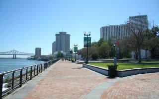
Scenic run through two riverfront parks along the Mississippi River, steps from the French Quarter. Great views of the Mississippi River, a festive scene, & numerous park features owing to recent improvements & connections. Good add-on opportunities!
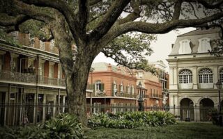
Get up early to beat the crowds and the heat for a special experience exploring the historic French Quarter. Enjoy the lovely architecture, flowers, and important sites on the streets that run 1 mile east-west and 0.5 miles north-south. Add w/Riverfront route!
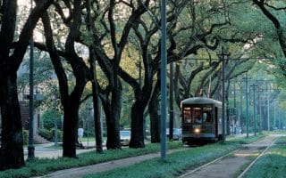
Beautiful, historic neighborhood for running, with elegant homes and a canopy of live oaks. Run with the trolleys along St. Charles Ave., then explore the Garden District neighborhood south of St. Charles.
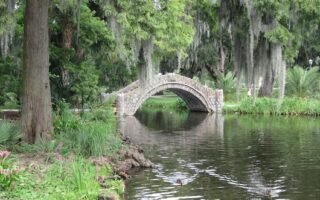
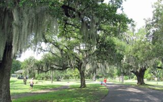
“As magical and unique as the city of New Orleans”, this 1,300-acre park is the 7th-most-visited urban park in the USA. Botanical gardens, lake loops, forest trails, & longer multi-use paths passing under historic live oaks. Can do a 5-6 mile run in the park, with good add-ons.
A paved multi-use path connecting the French Quarter with City Park. Wind your way through several historic New Orleans neighborhoods, passing sports fields & grassy lawns. Run standalone or combine with our French Quarter, Riverfront, or City Park routes.
One of the most popular routes for running in New Orleans. Upwards of 3,000 people run under a leafy canopy of live oaks and alongside a little lagoon, each day. Add on with the campus of Tulane University and the area's pretty residential streets.
Paved multi-use path atop the Mississippi River levee is a flat & uninterrupted run. There's a 22-mile section from Audubon Park west to St. Charles Parish and a 9-mile section in the Algiers Point area. Can be monotonous. Occasional river views, open & exposed.
Great running option located 15 miles east of New Orleans. Run along boardwalks and a gravel levee trail along a canal through protected marshland. You'll see lots of birds...and alligators!
The Tammany Trace Bike Trail begins on the north banks of Lake Pontchartrain, just across the causeway from New Orleans. The 31-mile paved multi-use trail plays an important role in connecting NOLA's northern suburbs.
Share your feedback on this route and see that of other Great Runs users. Click on the image icon to upload a photo. And please let us know if there are notes or changes we should incorporate!
Subscribe
0 Comments
Oldest
Newest
Inline Feedbacks
View all comments
Essentials
Nearly 20 miles of lakefront path: Divided into 5.6 mile promenade along Lakeshore Dr., and 12.4 mile Lakefront Trail, plus levee trail.
Flat
Depends on preferred access point. Breakwater Park at the 17th St. Canal is the dividing point between the east & west parts of the route
Car generally needed to get to this area. Ample parking on side streets. Lakeshore Dr. is 1 mile north of City Park.


Review or Comment on This Route/Share a Photo!
Share your feedback on this route and see that of other Great Runs users. Click on the image icon to upload a photo. And please let us know if there are notes or changes we should incorporate!