The Oxford Canal reaches north from Oxford all the way to the spires of Coventry. Along the way, a 77-mile towpath follows the waterside. Runners can follow the path for as long as they like, but the closest access point to Oxford is under the Hythe Street Bridge just outside Gloucester Green. The path follows along the perimeter of Port Meadow, then heads north through Kidlington and past the airport. It’s a suitable route for an out and back of any length, but it also makes a good loop when combined with Oxford Meadow or the University Parks/Marston Ferry paths. If you need a little inspiration, we’ve mapped a 10 km (6.2 mile) out and back between the Hythe Street Bridge and the Wolvercote Lakes at Duke’s Cut. It’s fun to combine this with some of the paths in Port Meadow.
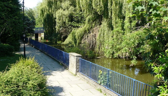
Peter Trimming
Features:
Scroll Down For Route Maps
Essentials
- We've mapped a 10k out and back. Canal path goes for up to 124 km (77 miles)
- Flat
- Oxford Access point: Hythe Street Bridge
- Oxford Station
Current Weather & Forecast

Oxford, GB
6:29 pm,
Jul 27, 2026
L: 25°
H: 25°
Daily ForecastHourly Forecast
Today
10:00 pm
25° / 25°°C
0 mm
0%
9 mph
43 %
1019 mb
0 mm/h
Tomorrow
10:00 pm
19° / 34°°C
0 mm
0%
4 mph
49 %
1021 mb
0 mm/h
Wednesday
10:00 pm
25° / 41°°C
0 mm
0%
9 mph
34 %
1015 mb
0 mm/h
Thursday
10:00 pm
23° / 35°°C
0.38 mm
38%
11 mph
50 %
1016 mb
0 mm/h
Friday
10:00 pm
20° / 31°°C
0 mm
0%
12 mph
66 %
1017 mb
0 mm/h
Today
7:00 pm
27° / 27°°C
0 mm
0%
9 mph
43 %
1019 mb
0 mm/h
Today
10:00 pm
22° / 26°°C
0 mm
0%
6 mph
41 %
1019 mb
0 mm/h
Tomorrow
1:00 am
19° / 22°°C
0 mm
0%
3 mph
41 %
1020 mb
0 mm/h
Tomorrow
4:00 am
19° / 19°°C
0 mm
0%
3 mph
46 %
1021 mb
0 mm/h
Tomorrow
7:00 am
20° / 20°°C
0 mm
0%
3 mph
49 %
1021 mb
0 mm/h
Tomorrow
10:00 am
26° / 26°°C
0 mm
0%
3 mph
32 %
1021 mb
0 mm/h
Tomorrow
1:00 pm
32° / 32°°C
0 mm
0%
2 mph
21 %
1019 mb
0 mm/h
Other Routes in Oxford, England
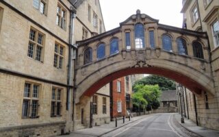
One of our favorite 'runseeing' tours in Europe. Historic buildings, Oxford University campus, River Thames paths, botanical gardens, historic bridges, and posh neighborhoods -- all in one easy-to-follow 9 km tour! Easy add-on opportunities.

There are many great running options featuring the multi-use paths lining the River Thames. Take the Thames Path south to the historic Iffley Lock, or further. Or, incorporate Thames paths with loops around Port Meadow and Christ Church Meadow.

The “University Parks” surrounding the River Cherwell in the east of Oxford have many great running paths. We’ve mapped a 5.5 km loop through the parks, and a 6.4 km tour of the Marston Ferry Path.
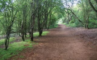
Opportunities for a light trail run abound on the paths of Shotover Country Park in Headington. Run the paths on their own, or follow our 5 km route to reach the park from the center of the city. It's also easily reachable by transport.

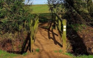
This UNESCO World Heritage Site is a worth-it destination run. Miles of smooth and scenic walking paths surround spectacular grounds and formal gardens of this 17th century estate. We've recommended certain trails and mapped a loop from Woodstock.
Looking for some fun and friendly competition? Cutteslowe and Sunnymead Park in northern Oxford is home to Parkrun, a free group 5k held every Saturday morning.
User Ratings
Leave A Review or Comment
Review or Comment on This Route/Share a Photo!
Share your feedback on this route and see that of other Great Runs users. Click on the image icon to upload a photo. And please let us know if there are notes or changes we should incorporate!