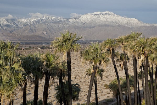
For some of the easier trail running options in the Coachella Valley, the Coachella Valley Preserve is a great option. The 17,000-acre preserve and the adjacent 880-acre Thousand Palms Oasis Preserve are located just northeast of the center of Palm Desert. Most of the preserve is in a valley, with numerous trails that make for easy to moderate trail running. Pro Tip: Try to catch the Preserve during a desert wildflower bloom. See our ‘Desert Blooms‘ List for info & annual calendars.
Google Street View
One can put together several miles combining the main trails off Thousand Palms Canyon Rd. These desert trails in the valley feature great views of the valley’s myriad colors and the surrounding mountains. The trails on the west side of Thousand Palms Canyon Rd. (McCallum, Indio Palms, Willis Palm) are favorites — oasis-like, leading to palm groves. They’re generally flatter and can be sandy. On the east side, trails like Pushawalla Palms can be a bit harsher and rockier.
Google Street View
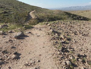
Note that the terrain is very open and it can be occasionally difficult to make out the specific trail — keep an eye our for cairns! Also, very exposed — use caution in the heat! There’s a visitor center and restrooms off Thousand Palms Canyon Rd. (but no water!). Note that the Preserve has set opening hours and some trails might be closed when the Preserve is closed.
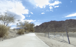
For some of the easier trail running options in the Coachella Valley, the Coachella Valley Preserve is a great option. The 17,000-acre preserve and the adjacent 880-acre Thousand Palms Oasis Preserve are located just northeast of the center of Palm Desert. Most of the preserve is in a valley, with numerous trails that make for easy to moderate trail running. Pro Tip: Try to catch the Preserve during a desert wildflower bloom. See our ‘Desert Blooms‘ List for info & annual calendars.
Google Street View
One can put together several miles combining the main trails off Thousand Palms Canyon Rd. These desert trails in the valley feature great views of the valley’s myriad colors and the surrounding mountains. The trails on the west side of Thousand Palms Canyon Rd. (McCallum, Indio Palms, Willis Palm) are favorites — oasis-like, leading to palm groves. They’re generally flatter and can be sandy. On the east side, trails like Pushawalla Palms can be a bit harsher and rockier.
Google Street View
Note that the terrain is very open and it can be occasionally difficult to make out the specific trail — keep an eye our for cairns! Also, very exposed — use caution in the heat! There’s a visitor center and restrooms off Thousand Palms Canyon Rd. (but no water!). Note that the Preserve has set opening hours and some trails might be closed when the Preserve is closed.
Scroll Down For Route Maps
Essentials
Many miles of trails in the park
300 feet
Various trailheads, or use Visitor Ctr. as an anchor
Visitor Center & Parking off Thousand Palms Canyon Rd.
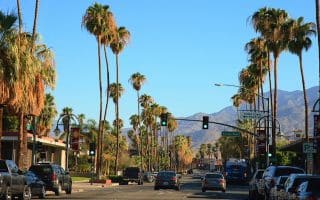
Our 6 mile downtown tour is situated within easy distance of most Palm Springs hotels, and covers some of the major tourist attractions and parks of Palm Springs.
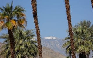
Stretching along the western limits of Palm Springs before the streets give way to mountain ranges, Palm Canyon Drive is one long, beautiful route that reaches from the city center all the way down to the Agua Caliente Indian Reservation.
This 4-mile loop takes you through the city's older, picturesque, palm-lined residential streets. Our route is derived from the City of Palm Springs bike map. There are good sidewalks.
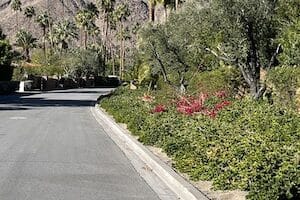
The neighborhoods of Old Las Palmas and Vista Las Palmas are some of the most gorgeous residential areas in Palm Springs, known for beautiful mid-century modern homes and celebrity status residents. Use our suggested route or create your own!
With this swift loop around the Palm Springs International Airport, you can explore the golf clubs and mountain vistas of downtown Palm Springs in one easy in and out loop.
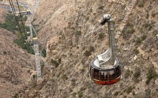
The Tram Road Challenge is a taxing 6k from Chino Canyon up to the 8,500 foot elevation of Mt. San Jacinto State Park. The run is up the access road paralleling the tram. Nearly 2,000 foot elevation gain, grades averaging 7-8%.
This 3.5 mile out and back on the South Lykken Trail, which rises up from South Palm Canyon Drive in lower Palm Springs, has great views of the Coachella Valley. Note: Dogs not permitted!
The Joe Butler Trail is a quiet run on an asphalt path in the Rancho Mirage neighborhood, stretching 2.5 miles (out and back) alongside a scenic golf club. Good run if you're staying at the Ritz Carlton.
In the center of Palm Desert, a quite nice run combining paths through Civic Center Park and the adjacent campus of the College of the Desert. Also, Magnesia Falls Dr. has a bike path along it's ~1 mile length. Overall, easy to stitch together a 4-5 mile run.
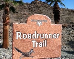
Terrific trail run in Rancho Mirage right off Rt. 111 and near the Ritz Carlton Hotel. Hilly. A 3.3 mile loop incorporates the Rd. Runner Trail and the Jack Rabbit Trail.
Nice run in the La Quinta area on paved multi-use path at the edge of the Santa Rosa Mountains. It's a steady climb over 2.7 miles. Can use the quiet residential of La Quinta for one of the ways. Nice mountain views!
Share your feedback on this route and see that of other Great Runs users. Click on the image icon to upload a photo. And please let us know if there are notes or changes we should incorporate!
Subscribe
0 Comments
Oldest
Newest
Inline Feedbacks
View all comments
Essentials
Many miles of trails in the park
300 feet
Various trailheads, or use Visitor Ctr. as an anchor
Visitor Center & Parking off Thousand Palms Canyon Rd.


Review or Comment on This Route/Share a Photo!
Share your feedback on this route and see that of other Great Runs users. Click on the image icon to upload a photo. And please let us know if there are notes or changes we should incorporate!