Vaucluse is one of the finest parts of Provence for running, with gems including the trails of the Luberon, and riverfront running routes in rampart-surrounded city of Avignon.
AVIGNON
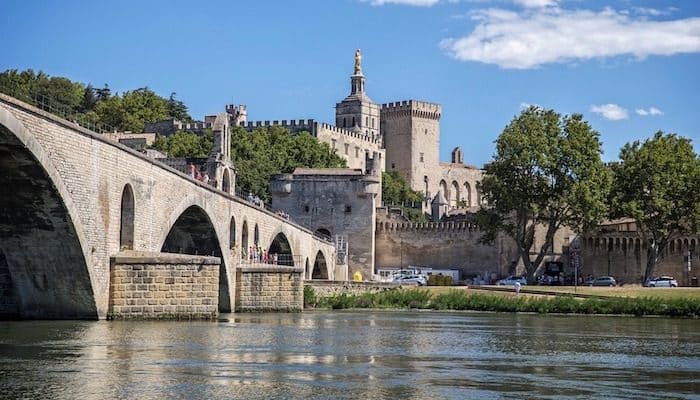
Barthelasse Island: Barthelasse is the longest river island in Europe, tucked between two branches of the Rhone in Avignon. The paths along waterfront make for one of the best city runs around Provence, with a paved loop around the island. Runners can start from the Chemin des Berges under the N580 bridge and head east along the waterfront, with great views of the Pont d’Avignon. Turn LEFT onto Chemin des Pêchers, heading inland, then bear RIGHT onto Chemin des Poiriers, a quiet paved route through orchard. At the end of the road, loop LEFT back to the waterfront and continue west to the Route de l’Islon. Turn LEFT on Route de l’Islon or the dirt path along the river, the bear LEFT onto the Chemin de Bellegarde. Follow this to Chemin de la Traille, then turn LEFT to return back to the southern waterfront. In total, the loop is about 15 km, but any section makes a great out and back. ROUTE MAP.
Avignon Waterfront: In the classic tradition of European river towns, Avignon has a great path along the Rhone. Runners can start as far east as Boulevard de la Ligne, but the best section begins across from the Escaliers Du Rocher Des Doms. It’s 3.6 km west to the railroad tracks. Another good option is to start in the Parc Palais de Papes, do a loop, then take the stairs down to the waterfront. Turn LEFT and and it’s possible to continue as far as the Monument du Comtat, where the path turns to dirt. The dirt path continues 1.6 km to the railroad tracks, making an out and back of up to 7.2 km possible. Note that the road alongside the path is quite busy. ROUTE MAP.
LUBERON
We consulted with the local tourist board to come up with several great routes in this lovely countryside.
Véloroute de Calavon: One of the best running routes in all of Provence is this designated greenway leading almost 40 km through the Maison Du Parc Naturel Régional du Luberon. The trail starts in the west near Robion and goes west along the Calavon river valley to Castellet. The route is mostly paved and separated from car traffic, although runners will definitely have to share the way with bicycles. Highlights include the Roman bridge (Pont Julien) over the river, and the viaducts crossing through the town of Apt. ROUTE MAP. TRAIL INFO.
Many cyclists also take to the hilly Autour du Luberon route. Though this 236 km itinerary is shared with cars, you may find some nice runnable sections there.
Forest of the Cedars: A popular hike/trail run in the Luberon, the Forest of the Cedars is a shady planted forest with impressive trees and great views from rock outcroppings. The Portales Trail is one of the best ways to explore the forest, and it’s a fairly easy trail run at 3 km. From the trailhead, turn LEFT following the yellow markings. Turn RIGHT onto the labyrinth boardwalk, then continue on the main route. Turn LEFT off of the Cedar Road, take another sharp LEFT, then continue downhill. At the mine, climb RIGHT out of the valley to reach the Le Portalas crossroads. Turn RIGHT and continue up a steep path to a scenic plateau. Continue right, then turn RIGHT at the next intersection. Follow the path into the undergrowth and stay straight as the route becomes paved. At the Bois Roustan intersection, turn RIGHT to continue back to the parking area. ROUTE MAP.
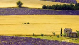
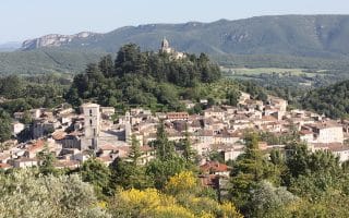
Plateau des Claparèdes: Another great trail in the Luberon, the Plateau des Claparèdes is famous for its lavender blooms. The 9 km trail here is easy and non-technical, so it’s a great spot to run amongst the colorful vegetation. From the car park, go east on the Marrenon road until the Barbe Blanche post, then turn LEFT onto the path towards Sivergues. Turn LEFT twice, then follow the unmarked dirt road northeast. At the next intersection, turn LEFT onto the path along the fields. Continue right, then emerge on a track and take it to the left. Follow the D232 for 45 m, then bear right onto a brushy path. At the next crossroads, turn LEFT along a lavender field. Go LEFT, then continue right to reach the D114. Follow it for a spell, then turn LEFT onto the path of Sivergues. This dirt road will carry you to an intersection with a small road. Turn RIGHT onto the road, then straight to the intersection Le Colombier. Continue straight into Les Fondons parking lot, then turn LEFT onto the D48. Continue straight on the dirt road, and loop back to Le Colombier. Turn RIGHT back to D232 and D1414. At the Vouliou post, turn right to Plaine Lambertes post, then turn LEFT, then LEFT again back to the start. ROUTE MAP.
Le Bois du Defends: This forest in Sault was set aside in the 17th century to provide lumber for the royal fleet. Today, it is home to multiple recreation trails and mountain biking courses that are great for running. The tourism board in Vaucluse has mapped a great 7 km route through the park. Start at the Hippodrome racetrack and take the stony path north (enjoying great views of Mont Ventoux). Pass Le Defends and continue on the crossroad Roumane. Follow the path to the right and pass the La Rouyere junction. Take the path on the right, and then take the first road on the right for 200 m. Then, follow the path on the left and exit on the D 950, in L’Hermitage. Cross the road, then follow it to the left. Turn off the first road on the right. The path loops and arrives in the ravine of Curni. Follow the dirt road on the left. The path levels, then rises to Eimine. Continue straight, following the path into the Pourraches woods. Cross the thalweg and go up the track for 200 m to Mougne. Continue in the same direction, then cross the D 950 to return to the starting point. ROUTE MAP.
For a shorter route, runners can stay straight at L’Hermitage and take the public road, then the greenway, along D950 back to the racetrack.
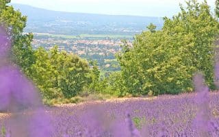
The Lavender Path: Clocking in at 5.3 km, Sault’s Lavender Path is one of the most gorgeous destinations in Provence. This little traveled road (marked with yellow) can be reached by driving 1.5 km from Sault towards Mount Ventoux. Go straight at the hairpin turn, then park on the right just after the distillery. To access the route, take the road going downhill, then turn right. The route can be run either clockwise or counter-clockwise. Counter-clockwise, you’ll follow a branch of the Nesque north, then turn LEFT at the junction. Keep bearing LEFT, and the path will continue southwest to Les Michouilles. At each next intersection, keep straight to return to the trailhead. ROUTE MAP.
Vaucluse is one of the finest parts of Provence for running, with gems including the trails of the Luberon, and riverfront running routes in rampart-surrounded city of Avignon.
AVIGNON
Barthelasse Island: Barthelasse is the longest river island in Europe, tucked between two branches of the Rhone in Avignon. The paths along waterfront make for one of the best city runs around Provence, with a paved loop around the island. Runners can start from the Chemin des Berges under the N580 bridge and head east along the waterfront, with great views of the Pont d’Avignon. Turn LEFT onto Chemin des Pêchers, heading inland, then bear RIGHT onto Chemin des Poiriers, a quiet paved route through orchard. At the end of the road, loop LEFT back to the waterfront and continue west to the Route de l’Islon. Turn LEFT on Route de l’Islon or the dirt path along the river, the bear LEFT onto the Chemin de Bellegarde. Follow this to Chemin de la Traille, then turn LEFT to return back to the southern waterfront. In total, the loop is about 15 km, but any section makes a great out and back. ROUTE MAP.
Avignon Waterfront: In the classic tradition of European river towns, Avignon has a great path along the Rhone. Runners can start as far east as Boulevard de la Ligne, but the best section begins across from the Escaliers Du Rocher Des Doms. It’s 3.6 km west to the railroad tracks. Another good option is to start in the Parc Palais de Papes, do a loop, then take the stairs down to the waterfront. Turn LEFT and and it’s possible to continue as far as the Monument du Comtat, where the path turns to dirt. The dirt path continues 1.6 km to the railroad tracks, making an out and back of up to 7.2 km possible. Note that the road alongside the path is quite busy. ROUTE MAP.
LUBERON
We consulted with the local tourist board to come up with several great routes in this lovely countryside.
Véloroute de Calavon: One of the best running routes in all of Provence is this designated greenway leading almost 40 km through the Maison Du Parc Naturel Régional du Luberon. The trail starts in the west near Robion and goes west along the Calavon river valley to Castellet. The route is mostly paved and separated from car traffic, although runners will definitely have to share the way with bicycles. Highlights include the Roman bridge (Pont Julien) over the river, and the viaducts crossing through the town of Apt. ROUTE MAP. TRAIL INFO.
Many cyclists also take to the hilly Autour du Luberon route. Though this 236 km itinerary is shared with cars, you may find some nice runnable sections there.
Forest of the Cedars: A popular hike/trail run in the Luberon, the Forest of the Cedars is a shady planted forest with impressive trees and great views from rock outcroppings. The Portales Trail is one of the best ways to explore the forest, and it’s a fairly easy trail run at 3 km. From the trailhead, turn LEFT following the yellow markings. Turn RIGHT onto the labyrinth boardwalk, then continue on the main route. Turn LEFT off of the Cedar Road, take another sharp LEFT, then continue downhill. At the mine, climb RIGHT out of the valley to reach the Le Portalas crossroads. Turn RIGHT and continue up a steep path to a scenic plateau. Continue right, then turn RIGHT at the next intersection. Follow the path into the undergrowth and stay straight as the route becomes paved. At the Bois Roustan intersection, turn RIGHT to continue back to the parking area. ROUTE MAP.
Plateau des Claparèdes: Another great trail in the Luberon, the Plateau des Claparèdes is famous for its lavender blooms. The 9 km trail here is easy and non-technical, so it’s a great spot to run amongst the colorful vegetation. From the car park, go east on the Marrenon road until the Barbe Blanche post, then turn LEFT onto the path towards Sivergues. Turn LEFT twice, then follow the unmarked dirt road northeast. At the next intersection, turn LEFT onto the path along the fields. Continue right, then emerge on a track and take it to the left. Follow the D232 for 45 m, then bear right onto a brushy path. At the next crossroads, turn LEFT along a lavender field. Go LEFT, then continue right to reach the D114. Follow it for a spell, then turn LEFT onto the path of Sivergues. This dirt road will carry you to an intersection with a small road. Turn RIGHT onto the road, then straight to the intersection Le Colombier. Continue straight into Les Fondons parking lot, then turn LEFT onto the D48. Continue straight on the dirt road, and loop back to Le Colombier. Turn RIGHT back to D232 and D1414. At the Vouliou post, turn right to Plaine Lambertes post, then turn LEFT, then LEFT again back to the start. ROUTE MAP.
Le Bois du Defends: This forest in Sault was set aside in the 17th century to provide lumber for the royal fleet. Today, it is home to multiple recreation trails and mountain biking courses that are great for running. The tourism board in Vaucluse has mapped a great 7 km route through the park. Start at the Hippodrome racetrack and take the stony path north (enjoying great views of Mont Ventoux). Pass Le Defends and continue on the crossroad Roumane. Follow the path to the right and pass the La Rouyere junction. Take the path on the right, and then take the first road on the right for 200 m. Then, follow the path on the left and exit on the D 950, in L’Hermitage. Cross the road, then follow it to the left. Turn off the first road on the right. The path loops and arrives in the ravine of Curni. Follow the dirt road on the left. The path levels, then rises to Eimine. Continue straight, following the path into the Pourraches woods. Cross the thalweg and go up the track for 200 m to Mougne. Continue in the same direction, then cross the D 950 to return to the starting point. ROUTE MAP.
For a shorter route, runners can stay straight at L’Hermitage and take the public road, then the greenway, along D950 back to the racetrack.
The Lavender Path: Clocking in at 5.3 km, Sault’s Lavender Path is one of the most gorgeous destinations in Provence. This little traveled road (marked with yellow) can be reached by driving 1.5 km from Sault towards Mount Ventoux. Go straight at the hairpin turn, then park on the right just after the distillery. To access the route, take the road going downhill, then turn right. The route can be run either clockwise or counter-clockwise. Counter-clockwise, you’ll follow a branch of the Nesque north, then turn LEFT at the junction. Keep bearing LEFT, and the path will continue southwest to Les Michouilles. At each next intersection, keep straight to return to the trailhead. ROUTE MAP.
The southwesternmost district of Provence, Bouches du Rhone's most noteworthy running cities are Aix-en-Provence, and of course, Marseille (where we've prepared an extensive separate running guide.
Running in the quiet Haute Alps district of northern Provence is a little harder to find, but we've mapped out a great 10 km route of the vineyards and villages in the area known as Enclave des Papes.
The most central of Provence's districts, Alpes de Haute Provence is home to several pastoral routes. Enjoy the capital of Digne Les Baines, trails in historic Forcalquier, the ski village of Pra Loup, and the pastoral Jabron valley.
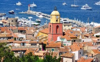
The Var region, on the south central coast, has some of the best running in Provence, from the lengthy cycling paths near Draguignan, to the trails of Villacroze, to the coastal views of Saint Tropez, Saint Cyr, Sansary, and Porquerolles.
Some nice waterfront promenade paths in the Toulon area: nearly 6 km from the ferry terminal to Mourillon Beach, and 4.5 km in La Seyne-sur-Mer. Trail runners will love the extensive network of coastal paths. Great views!
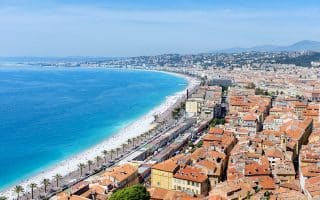
For runs in the southeastern region of Provence, also known as the Côte d’Azur or French Riviera, check out our guides to Nice, Cannes, and the surrounding areas, which includes more than 20 spectacular routes along the coast and in the hills.
Share your feedback on this route and see that of other Great Runs users. Click on the image icon to upload a photo. And please let us know if there are notes or changes we should incorporate!
 Le Bois du Defends: This forest in Sault was set aside in the 17th century to provide lumber for the royal fleet. Today, it is home to multiple recreation trails and mountain biking courses that are great for running. The tourism board in Vaucluse has mapped a great 7 km route through the park. Start at the Hippodrome racetrack and take the stony path north (enjoying great views of Mont Ventoux). Pass Le Defends and continue on the crossroad Roumane. Follow the path to the right and pass the La Rouyere junction. Take the path on the right, and then take the first road on the right for 200 m. Then, follow the path on the left and exit on the D 950, in L’Hermitage. Cross the road, then follow it to the left. Turn off the first road on the right. The path loops and arrives in the ravine of Curni. Follow the dirt road on the left. The path levels, then rises to Eimine. Continue straight, following the path into the Pourraches woods. Cross the thalweg and go up the track for 200 m to Mougne. Continue in the same direction, then cross the D 950 to return to the starting point. ROUTE MAP.

Review or Comment on This Route/Share a Photo!
Share your feedback on this route and see that of other Great Runs users. Click on the image icon to upload a photo. And please let us know if there are notes or changes we should incorporate!