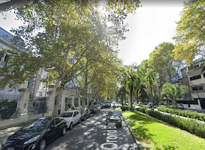
This is a great way to see central Rosario on runnable, wide avenues passing the key sights and neoclassical, Art Nouveau, and Art Deco architecture of Distrito Centro, plus 2-3 km around the paths of Parque Independencia, the city’s major park.
Bv. Oroño. Google Street View
A good place to start is at the imposing Monumento Histórico Nacional a la Bandera, honoring Argentine hero Manuel Belgrano. Run for 2.5 km through the plaza and then west along Av. Córdoba — Rosario’s main commercial avenue that’s pedestrianized for seven blocks, between Plaza 25 de Mayo and Plaza Pringles — and includes several squares/plazas. Turn LEFT on Bv. Oroño, a wide, tree-shaded boulevard, and run for 1 km south to Parque Independencia. There, you can do 2-3 km on paths around the gardens and small ponds. Then, head back east toward the river for 2.5 km on the runnable Av. Pellegrini, finishing the final 2 km on the river paths– either through Parque Urquiza west of Av. Belgrano, or on the riverside sidewalk/path on the east side of Av. Belgrano.
Add-Ons: Connect with our Paraná River route for up to 6 km through several riverside parks.
Scroll Down For Route Maps
Essentials
8.5 km (5.3 miles) road section, plus 2-3 km in Parque Independencia
35m (115 feet)
Monumento Histórico Nacional a la Bandera, or any point more convenient
A series of paths along the Paraná River offers the best opportunity for a longer, scenic, mainly off-road run in Rosario. One can run for 6.3 km between Parque Urquiza and Puerto Norte. Nice water views, pleasant parks, Bandera Monument.
A pleasant run in the northern part of Rosario, combining a loop of Parque Alem with a cycle path alongside Av. Eudoro Carrasco to La Florida Beach. The northern ~1 km has some nice water views.
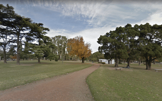
Pleasant park for running in the southeastern part of Rosario. Some 2-3 km of shaded, dirt trails, including some along the Saladillo River. Nice waterfalls near the bridge. Can also run over the bridge and continue on Juan Pablo II.
Share your feedback on this route and see that of other Great Runs users. Click on the image icon to upload a photo. And please let us know if there are notes or changes we should incorporate!
Subscribe
0 Comments
Oldest
Newest
Inline Feedbacks
View all comments
Essentials
8.5 km (5.3 miles) road section, plus 2-3 km in Parque Independencia
35m (115 feet)
Monumento Histórico Nacional a la Bandera, or any point more convenient


Review or Comment on This Route/Share a Photo!
Share your feedback on this route and see that of other Great Runs users. Click on the image icon to upload a photo. And please let us know if there are notes or changes we should incorporate!