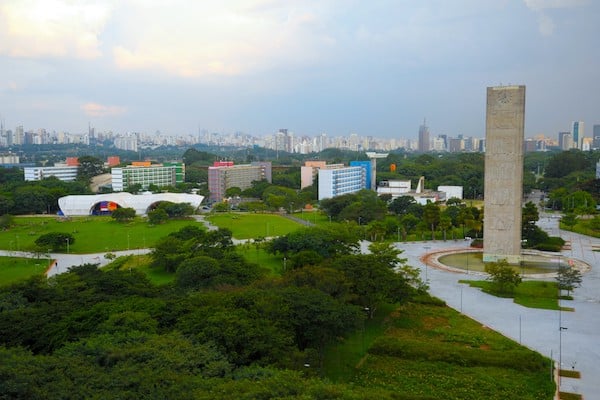
Running on the University of São Paulo campus is a popular spot for runners in the city. campus features long paved streets, small parks, and some good hills. There are a couple of good options for running: we’ve mapped out a route beginning at Av. da Universidade near the University Library, following the perimeter of the campus for a 5.8 km (3.6 mile) loop. One can also run adjacent to the road on the paths of the river/OIympic Basin, though some sections are fenced off.
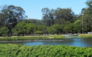
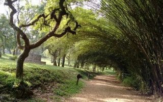
R. do Lago, from Google Street View
Another good option to add on and create a longer or shorter route by exploring the inner streets of the campus. The middle of the busier roads include biking and running lanes safe for runners. Many of the roads are pleasantly shaded, with dirt side paths. Examples are R. do Matão, R. do Lago, each of which runs for about 1 mile. Note: Not open to the public on Sundays.
For a longer run, head across the river (Av. Prof. Manuel José Chaves bridge), to the Alto de Pinheiros neighborhood. You’ll find paths along the water, and the Park Villa Lobos, plus some streets OK for running.
Running on the University of São Paulo campus is a popular spot for runners in the city. campus features long paved streets, small parks, and some good hills. There are a couple of good options for running: we’ve mapped out a route beginning at Av. da Universidade near the University Library, following the perimeter of the campus for a 5.8 km (3.6 mile) loop. One can also run adjacent to the road on the paths of the river/OIympic Basin, though some sections are fenced off.
R. do Lago, from Google Street View
Another good option to add on and create a longer or shorter route by exploring the inner streets of the campus. The middle of the busier roads include biking and running lanes safe for runners. Many of the roads are pleasantly shaded, with dirt side paths. Examples are R. do Matão, R. do Lago, each of which runs for about 1 mile. Note: Not open to the public on Sundays.
For a longer run, head across the river (Av. Prof. Manuel José Chaves bridge), to the Alto de Pinheiros neighborhood. You’ll find paths along the water, and the Park Villa Lobos, plus some streets OK for running.
Scroll Down For Route Maps
Essentials
5.8 km (3.6 mile) perimeter loop. Other options for add-on or variety
Flat
Av.da Universidade, near Praça Professor Rubião Meira (Square)
The Cidade Universitária CPTM Stop (L09); Other bus routes nearby
One of Latin America’s largest city parks, with many natural and cultural sites. Follow one of the four mapped running courses or create your own! There are lovely paths, gardens, bike paths, several museums and interesting buildings.
Our São Paulo's 'runseeing tour' includes the Praça da República, São Paulo Cathedral, and mix of older and more modern buildings. Go early to beat the crowds & traffic. Combine with the Minhocão, an elevated highway closed to cars evenings & weekends.
Run on an elevated highway! The Minhocão (Via Elevada Presidente João Goulart) is a 3.5 km elevated highway in downtown São Paulo that's closed to cars weekends and evenings. A festive scene, with great views of the São Paulo skyline.
Parque Villa-Lobos is one of São Paulo’s best outdoor leisure destinations. With running routes, biking routes, hiking trails and sports fields, the park offers many options for those looking for some activity. There are paths of 700 m to 2.1 km for running.
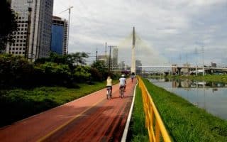
One of the best opportunities for a longer off-road run in São Paulo. The cycle path runs along the Pinhheiros River for 22 km from Parque Villa-Lobos south to the Jurubatuba. Nice water views.
No awards for scenery, but a good way to clock some miles! A cycle path runs in the median of the main road that runs for up to 14 km between our Parque Villa-Lobos and Parque Ibirapuera routes.
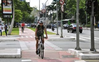
A centrally located road accessing many of São Paulo's interesting points, in the Perdizes neighborhood. Busy, but with bike/pedestrian path along the center of the road. It's about 6.5 km out and back between Allianz Stadium and the Av. Paulo VI end.
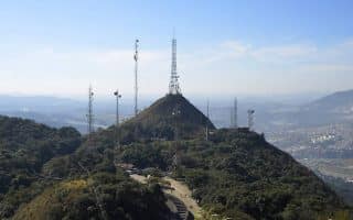
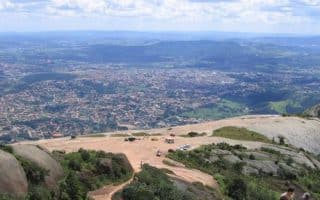
For those who would like to get some challenging hill running in, this 2.9 mile climb to the summit is tough but rewarding. Great views from the top. One can run on the road or numerous trails in the park if a more technical route is preferred.
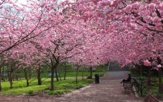
Park in the eastern part of São Paulo, with several km of trails. Many trees and shade. Attractions include a natural amphitheater, a cherry tree grove, and the Arthur Etzel Nursery. Come during cherry blossom season in July -- beautiful but crowded!
A municipal park about 30 km west of the city with numerous paths that are great for running. A combination of open lawns and wooded trails. Lovely vegetation. A loop around the perimeter paths is about 4 km.
Large state park north of São Paulo, with remnants of the Atlantic Forest. Some good, but challenging, running and trail running opportunities. A highlight is the walk/hike/run to Pedra Grande, at 3,100 feet, which is a 935 foot elevation gain over 2.4 miles.
Share your feedback on this route and see that of other Great Runs users. Click on the image icon to upload a photo. And please let us know if there are notes or changes we should incorporate!
Subscribe
0 Comments
Oldest
Newest
Inline Feedbacks
View all comments
Essentials
5.8 km (3.6 mile) perimeter loop. Other options for add-on or variety
Flat
Av.da Universidade, near Praça Professor Rubião Meira (Square)
The Cidade Universitária CPTM Stop (L09); Other bus routes nearby


Review or Comment on This Route/Share a Photo!
Share your feedback on this route and see that of other Great Runs users. Click on the image icon to upload a photo. And please let us know if there are notes or changes we should incorporate!