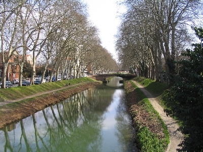
Run for 250 km to the Mediterranean! The Canal de Midi multi-use path runs right along the water from Toulouse southeast to the sea. The canal was built 1666-1681 and lined with plane trees, which now provide a pleasant canopy and shade on hot days. The path alternates between paved and gravel sections, and dips below bridges at most intersections. Run for as long many km as you like! This site has detailed information on the Canal, segment distances, and sites along the way. A detailed map of the entire route that can be purchased.
We’ve mapped the first 25 km from Toulouse to Montgiscard. You can start at the Garonne River and run along Boul. Marquette for 5 km, or near the Grand Rond if you’d prefer to eliminate the first few ‘urban’ km. Then, just follow the path south for as long as you like! Our route is mainly on the eastern side of the canal, but there are sections where there are paths on both sides of the canal.

Review or Comment on This Route/Share a Photo!
Share your feedback on this route and see that of other Great Runs users. Click on the image icon to upload a photo. And please let us know if there are notes or changes we should incorporate!