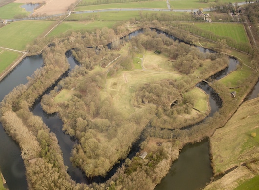
Outside the canal paths, the area around Fort Rhijnauwen and the Amelisweerd National Forest is our favorite place to run in Utrecht. Located a few km east of the city, Fort Rhijnauwen is a 19th century fort that used water defenses to form an ‘island’ fort. A paved 3.5 km path, the Vossegatsedijk, forms a great perimeter loop of the fort.
Amelisweerd Estate. Wikimedia Commons
Adjacent to the fort are the grounds of the Rhijnauwen and Amelisweerd estates, former manors that are now a National Forest. There are gorgeous gravel trails in this area, a combination of paths around the beautifully landscaped estate grounds and some more wooded paths at the western edge of the area. You can create your own route of several km here. We’ve mapped a 5.6 km loop that combines the estate/forest trails headed to the western end, and then returning on a path called Jaagpad, which runs along the Kromme Canal. For a longer run, the combine the fort & forest loops for 9 km, or add on with additional trails in the area.
Add-Ons: Just north of the fort, there are nice paths around the University of Utrecht and the Utrecht Botanical Gardens.
Scroll Down For Route Maps
Essentials
Fort Loop: 3.5 km (2.2 miles); Estate/Forest Loop: 5.6 km (3.5 miles)
Flat
Parking area near the Teahouse is a good starting point
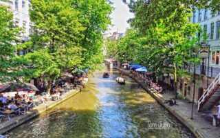
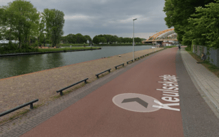
This is a ‘runseeing’ tour of Utrecht, which includes the Oudegracht and Singlel canals, parks, and the city’s historic center. Use our map as a guideline — there are several ways to vary the route and lots of add-on options.
The Vecht is one of the more scenic canal-side running options in Utrecht. It's up to 7.5 km one-way, starting from just north of the city centre, through Overvecht to the N230 in Oud-Zuilen, passing houseboats and an increasingly green landscape headed north.
The largest park in the Netherlands and a joy for running. Many km of pedestrian and cycle paths, water features, and attractive landscaping. It's 3 km north-south and 1 km east-west. One good option is the 10k perimeter path. Just west of the city centre.
Just south of the city centre, combine the paths around the University of Utrecht, the Oostbroek Estate, Botanical Gardens, and a couple of adjacent parks. Create your own mix & match route using the numerous paths around and connecting these areas!
Stitch together your own route in Wittevrouwen, Oudwijk, and Tuindorp neighborhoods in eastern Utrecht. These are some of the more attractive neighborhoods in the city, with pretty streets and numerous parks. A highlight is Wilhelminapark in the Oudwijk area.
A nice run in the western part of Utrecht, featuring multi-use paths along the Rijnkanaal and Transwijk Park. Nice water views, bridges, and park paths. Most of the route is off-road.
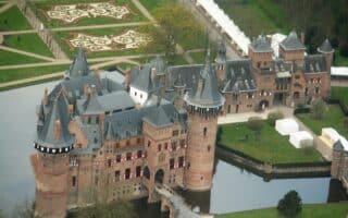
Enjoy a run on the 135 acres of gorgeously landscaped grounds of the Netherlands' largest castle. Manicured gardens, ponds, bridges, romantic vistas, and impressive avenues. Adjacent parks and preserves for a longer run. Note: fee required.
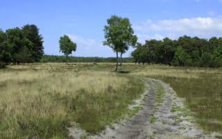
A worth-it destination run! This 6,000 hectare national park is 20 km east of Utrecht and features hundreds of km of trails and paths through heaths, sand dunes, forests, grass lands and floodplains. There are 50+ designated 'walks' ranging from 2 to 21 km.
Share your feedback on this route and see that of other Great Runs users. Click on the image icon to upload a photo. And please let us know if there are notes or changes we should incorporate!
Subscribe
0 Comments
Oldest
Newest
Inline Feedbacks
View all comments
Essentials
Fort Loop: 3.5 km (2.2 miles); Estate/Forest Loop: 5.6 km (3.5 miles)
Flat
Parking area near the Teahouse is a good starting point


Review or Comment on This Route/Share a Photo!
Share your feedback on this route and see that of other Great Runs users. Click on the image icon to upload a photo. And please let us know if there are notes or changes we should incorporate!