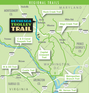
Montgomery County flanks Washington DC to the north, and is home to a large population of the metropolitan area’s residents. The affluent county has some gorgeous residential neighborhoods throughout the main regions including Bethesda, Silver Spring, and Chevy Chase, as well as an extensive network of bike paths public parks. The small map on the left shows the network of major trails in the MD. area.
For public transport, there’s the Red Line of the Washington Metrorail, the Metrobus, or even White’s Ferry, which crosses the Potomac River.
Capital Crescent Trail: D.C. (Georgetown) to Bethesda
A wonderful paved bike trail runs the 7 miles between Georgetown (In D.C.) to the pretty and affluent town of Bethesda. The Capital Crescent Trail offers a relatively flat and scenic run, with much of the trail bordering the Chesapeake and Ohio Canal Towpath (C&O) Trail, so you can cut the monotony of an out and back route with a loop on the two trails.
A flat, 184-mile tow path along the Potomac River from D.C. to Cumberland. In D.C. the trail starts in Georgetown, then intersects with Rock Creek Park, and parallels the Clara Burton Parkway on the northeast of the D.C./Maryland border. It’s 5 miles from D.C. to Lock 5, just over the MD border, 10 miles to Billy Goat Trail C, near Carderock, and 15 miles to the Great Falls Tavern Visitor Center.
Cabin John Regional Park — Bethesda/Rockville Area
For runners situated on the west side of Bethesda or south of Rockville, the scenic woods of Cabin John Park are an ideal outdoor run. It’s not all trail running — while there are 4 miles of natural paths, there is also a 2 mile paved loop which is great for a quick run or laps. However, local runners agree the nicest stretch is the slightly more rugged Cabin John Stream Valley Trail, which borders the Cabin John Creek for about nine miles.
Though the rail trails of the DC suburbs are beautiful for running, they can sometimes be quite crowded. If you’d prefer to set out on your own on neighborhood streets, look no further than the Garrett Park neighborhood of Kensington. It’s dappled with stately old homes, magnificent trees, and windy streets which stretch up moderate hills. The main strip is Beach Drive, which borders the Rock Creek Trail, but the areas around Kenilworth Ave, Rockeby Ave, and Montrose Ave offer long vertical stretches without much traffic.
1800-acre park includes Lake Frank and Lake Needwood, plus 13 miles of trails — some paved, others unpaved and wooded. There are trails along the shore of Lake Needwood which are great for running. Lake Frank trails are more for trail running. The Rock Creek Hiker-Biker Trail starts at Lake Needwood and continues for uo t 18 miles to D.C.
Rock Creek Park is a hidden gem from our D.C. running guide, but it’s a also staple for those on the Maryland side. On those hot Washington days, Rock Creek park is a wonderful opportunity to run along a shaded pathway and enjoy the lush Washington foliage.
There are myriad options for running in Rock Creek Park. Doug Hay has published an excellent guide. The principal running path is the Rock Creek Trail, which is mostly paved and is about 10 miles in length. There are two main sections:
South Section. ~5 miles. The southern section runs from Pierce Mill (intersection of Tilden and Beach Dr. NW) in D.C. to the Memorial Bridge. The paved path winds its way down the park, for the most part sticking pretty close to both the creek and Beach Drive. You’ll run by the National Zoo, the Kennedy Center, and reach the Memorial Bridge. Connect with the Memorial trails and the Mount Vernon trail.
North Section. ~4.6 miles. This heads up to the Maryland border from Pierce Mill, mainly paralleling Beach Drive. On weekends and holidays, the ~4 mile section of Beach Drive is closed off to cars.
For more detailed information, plus info on the Georgetown Connector Trail, see our D.C. guide here.
North Bethesda/Trolley Trail — Connects North & Central Bethesda
The North Bethesda Trail, sometimes referred to as the Trolley Trail, is a paved rail trail between Central and North Bethesda. It starts about 1 mile north of downtown, Bethesda and runs for 4.5 miles ONE-WAY north to the Montgomery County Conference Center (Metro Station). Right near the southern terminus is the extensive campus of the National Institutes of Health (NIH). I-495 bisects the trail at the halfway mark. Because the path doesn’t carry on into the city like some of the other rail trails, it’s a little quieter, and perfect for local recreation. Some of the path is broken up onto sidewalks and street, so it’s a good option for those who prefer exploring a neighborhood through road and urban running. There’s a plan to continue the trail 2 miles further north toward Rockville.
Several great routes in the communities of Arlington, Reston, Alexandria, Tyson’s Corner, and Fairfax. Highlights are routes in Old Town Alexandria, Mt. Vernon Trail, W&OD Trail, Custis Trail, Four Mile Run Trail, Great Falls Park, trails in Reston.
Share your feedback on this route and see that of other Great Runs users. Click on the image icon to upload a photo. And please let us know if there are notes or changes we should incorporate!
 Montgomery County flanks Washington DC to the north, and is home to a large population of the metropolitan area’s residents. The affluent county has some gorgeous residential neighborhoods throughout the main regions including Bethesda, Silver Spring, and Chevy Chase, as well as an extensive network of bike paths public parks. The small map on the left shows the network of major trails in the MD. area.
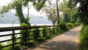 A wonderful paved bike trail runs the 7 miles between Georgetown (In D.C.) to the pretty and affluent town of Bethesda. The Capital Crescent Trail offers a relatively flat and scenic run, with much of the trail bordering the Chesapeake and Ohio Canal Towpath (C&O) Trail, so you can cut the monotony of an out and back route with a loop on the two trails.
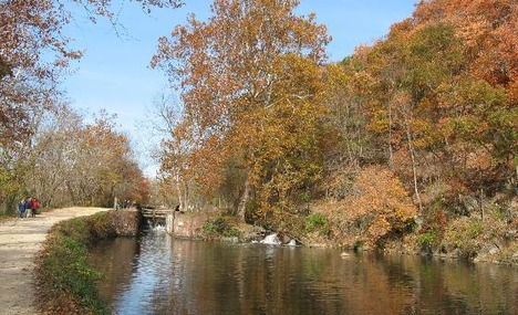 A flat, 184-mile tow path along the Potomac River from D.C. to Cumberland. In D.C. the trail starts in Georgetown, then intersects with Rock Creek Park, and parallels the Clara Burton Parkway on the northeast of the D.C./Maryland border. It’s 5 miles from D.C. to Lock 5, just over the MD border, 10 miles to Billy Goat Trail C, near Carderock, and 15 miles to the Great Falls Tavern Visitor Center.
 For runners situated on the west side of Bethesda or south of Rockville, the scenic woods of Cabin John Park are an ideal outdoor run. It’s not all trail running — while there are 4 miles of natural paths, there is also a 2 mile paved loop which is great for a quick run or laps. However, local runners agree the nicest stretch is the slightly more rugged Cabin John Stream Valley Trail, which borders the Cabin John Creek for about nine miles.
  Though the rail trails of the DC suburbs are beautiful for running, they can sometimes be quite crowded. If you’d prefer to set out on your own on neighborhood streets, look no further than the Garrett Park neighborhood of Kensington. It’s dappled with stately old homes, magnificent trees, and windy streets which stretch up moderate hills. The main strip is Beach Drive, which borders the Rock Creek Trail, but the areas around Kenilworth Ave, Rockeby Ave, and Montrose Ave offer long vertical stretches without much traffic.
 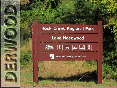 1800-acre park includes Lake Frank and Lake Needwood, plus 13 miles of trails — some paved, others unpaved and wooded. There are trails along the shore of Lake Needwood which are great for running. Lake Frank trails are more for trail running. The Rock Creek Hiker-Biker Trail starts at Lake Needwood and continues for uo t 18 miles to D.C.
 Rock Creek Park is a hidden gem from our D.C. running guide, but it’s a also staple for those on the Maryland side. On those hot Washington days, Rock Creek park is a wonderful opportunity to run along a shaded pathway and enjoy the lush Washington foliage.
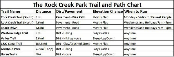
 The North Bethesda Trail, sometimes referred to as the Trolley Trail, is a paved rail trail between Central and North Bethesda. It starts about 1 mile north of downtown, Bethesda and runs for 4.5 miles ONE-WAY north to the Montgomery County Conference Center (Metro Station). Right near the southern terminus is the extensive campus of the National Institutes of Health (NIH). I-495 bisects the trail at the halfway mark. Because the path doesn’t carry on into the city like some of the other rail trails, it’s a little quieter, and perfect for local recreation. Some of the path is broken up onto sidewalks and street, so it’s a good option for those who prefer exploring a neighborhood through road and urban running. There’s a plan to continue the trail 2 miles further north toward Rockville.
Review or Comment on This Route/Share a Photo!
Share your feedback on this route and see that of other Great Runs users. Click on the image icon to upload a photo. And please let us know if there are notes or changes we should incorporate!