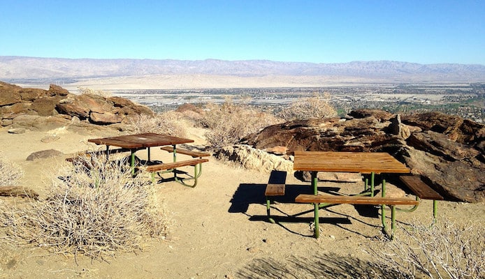
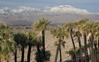
No matter how scenic the interior of the Coachella Valley is, local runners will tell you it is best experienced from above. And the easiest to access views are from the South Lykken Trail, which rises up from South Palm Canyon Drive in lower Palm Springs. Some sections are steep, with grades above 10%, so you’re in for a good workout, but this trail is flat and moderate enough to run on in most sections. The trail runs on for nearly 8 miles, but the best out and back for a run is about 3.5 miles roundtrip to the picnic area and back. Stop at the top and be rewarded with astonishing views of Palm Springs sprawling below. Shade here can be sparse, so it’s best as an early morning or evening route. NOTE: No dogs permitted on this trail — they give tickets!
Features:
Categories:
Scroll Down For Route Maps
Essentials
- 3.5 miles
- 723 feet
- South Palm Canyon Drive
- By car only
Current Weather & Forecast

Palm Springs, US
3:29 am,
Jun 19, 2026
L: 20°
H: 24°
Daily ForecastHourly Forecast
Today
2:00 pm
20° / 24°°C
0 mm
0%
10 mph
72 %
1012 mb
0 mm/h
Tomorrow
2:00 pm
29° / 35°°C
0.97 mm
97%
13 mph
78 %
1013 mb
0 mm/h
Sunday
2:00 pm
27° / 32°°C
1 mm
100%
9 mph
78 %
1013 mb
0 mm/h
Monday
2:00 pm
26° / 30°°C
1 mm
100%
7 mph
81 %
1012 mb
0 mm/h
Tuesday
2:00 pm
26° / 32°°C
1 mm
100%
8 mph
84 %
1012 mb
0 mm/h
Today
5:00 am
31° / 31°°C
0 mm
0%
10 mph
62 %
1010 mb
0 mm/h
Today
8:00 am
31° / 31°°C
0 mm
0%
8 mph
65 %
1012 mb
0 mm/h
Today
11:00 am
31° / 31°°C
0 mm
0%
6 mph
72 %
1012 mb
0 mm/h
Today
2:00 pm
28° / 28°°C
0 mm
0%
5 mph
72 %
1011 mb
0 mm/h
Today
5:00 pm
29° / 29°°C
0 mm
0%
3 mph
71 %
1012 mb
0 mm/h
Today
8:00 pm
33° / 33°°C
0 mm
0%
2 mph
55 %
1013 mb
0 mm/h
Today
11:00 pm
35° / 35°°C
0 mm
0%
6 mph
47 %
1010 mb
0 mm/h
Other Routes in Palm Springs, CA
Our 6 mile downtown tour is situated within easy distance of most Palm Springs hotels, and covers some of the major tourist attractions and parks of Palm Springs.

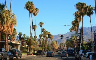
Stretching along the western limits of Palm Springs before the streets give way to mountain ranges, Palm Canyon Drive is one long, beautiful route that reaches from the city center all the way down to the Agua Caliente Indian Reservation.
This 4-mile loop takes you through the city's older, picturesque, palm-lined residential streets. Our route is derived from the City of Palm Springs bike map. There are good sidewalks.
The neighborhoods of Old Las Palmas and Vista Las Palmas are some of the most gorgeous residential areas in Palm Springs, known for beautiful mid-century modern homes and celebrity status residents. Use our suggested route or create your own!

With this swift loop around the Palm Springs International Airport, you can explore the golf clubs and mountain vistas of downtown Palm Springs in one easy in and out loop.
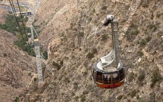
The Tram Road Challenge is a taxing 6k from Chino Canyon up to the 8,500 foot elevation of Mt. San Jacinto State Park. The run is up the access road paralleling the tram. Nearly 2,000 foot elevation gain, grades averaging 7-8%.
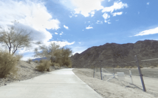
The Joe Butler Trail is a quiet run on an asphalt path in the Rancho Mirage neighborhood, stretching 2.5 miles (out and back) alongside a scenic golf club. Good run if you're staying at the Ritz Carlton.

In the center of Palm Desert, a quite nice run combining paths through Civic Center Park and the adjacent campus of the College of the Desert. Also, Magnesia Falls Dr. has a bike path along it's ~1 mile length. Overall, easy to stitch together a 4-5 mile run.
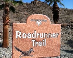
Terrific trail run in Rancho Mirage right off Rt. 111 and near the Ritz Carlton Hotel. Hilly. A 3.3 mile loop incorporates the Rd. Runner Trail and the Jack Rabbit Trail.
Nice run in the La Quinta area on paved multi-use path at the edge of the Santa Rosa Mountains. It's a steady climb over 2.7 miles. Can use the quiet residential of La Quinta for one of the ways. Nice mountain views!
Just north of Palm Desert, these adjacent preserves feature numerous trails off Thousand Palms Canyon Rd. with views of the valley & surrounding mountains, oasis features, & palm groves. Fairly flat, with decent footing.
User Ratings
Leave A Review or Comment
Review or Comment on This Route/Share a Photo!
Share your feedback on this route and see that of other Great Runs users. Click on the image icon to upload a photo. And please let us know if there are notes or changes we should incorporate!