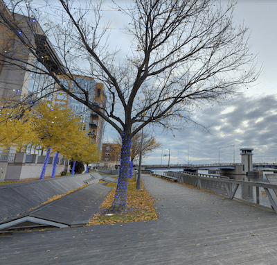
The Fox River Trail is among the signature running spots in Green Bay. A multi-use path runs along the Fox River for nearly 26 miles to Greenleaf. The first 11 miles are paved. We particularly love the first 6 miles between Green Bay and De Pere, as the trail is right along the river and features wonderful water views. There are good map kiosks along the way.
Google Street View
One can start right in Green Bay at Main St. and head south. The path follows the eastern bank of the river, passing through several parks. At De Pere (6-mile mark), the trail turns inland and gets more remote.
Add-Ons: At the Green Bay end, add an 0.5 mile section of the East River Trail headed north. You can also run for 0.5 miles on the west side of the river in Green Bay. Best to use the Walnut St. Bridge to cross.
Scroll Down For Route Maps
Essentials
Up to 26 miles one-way. Preferred section is the 6 miles between Green Bay & De Pere
First 6 miles are flat. Then gains ~400 feet between miles 11 and 25
Paved multi-use path follows the East River for 8.8 miles through the communities of Green Bay, Bellevue, Allouez, DePere and Ledgeview. Mainly wooded, with some water views. Running track at northern terminus.
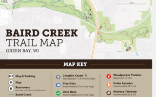
A paved, mainly wooded linear park path following Baird Creek. It's less of a water-side trail than the Fox River Trail or the East River Trail. The main path is 3.3 miles, and there are several offshoot trails that are more for trail running.
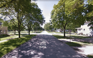
Just south of downtown, there's lovely running in the historic Astor Park & Allouez neighborhoods, with tree-shaded streets, sidewalks, and historic homes. Can add with river paths.
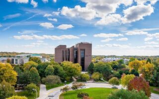
In the eastern part of Green Bay, stitch together a terrific run combining the paths of the UWGB campus, the Shorewood Cross Country Course, and six miles of trails at the Coflin Arborerum.
One of the longest rail trails in Wisconsin. The trail runs for 83 miles from the northwest part of Green Bay to Weston, just east of Wasuau. Lovely farmland, fairly flat, easy crushed stone surface.
Another in a series of longer multi-use trails in the Green Bay area. The gravel rails-to-trails multi-use path goes for 13 miles west to Seymour. It's a mainly wooded corridor, passing by farms. Continues as the Newton Blackmour State Trail west of Seymour.
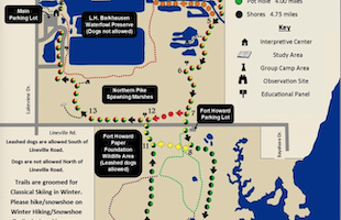
Good options for trail running just north of Green Bay. Barkhausen has 9 miles of trails around forest, marshland, & wetlands. Reforestation Camp has 7 miles of trails that are more rugged. NOTE: used for XC skiing in winter.
A long-distance mutli-use path, 48 miles overall in Luxemburg, Kewaunee, Algoma, and Sturgeon Bay. Luxemburg is closest access to Green Bay. Evergreen glades, farmland, prairies and wooded sections.
Share your feedback on this route and see that of other Great Runs users. Click on the image icon to upload a photo. And please let us know if there are notes or changes we should incorporate!
Subscribe
0 Comments
Oldest
Newest
Inline Feedbacks
View all comments
Essentials
Up to 26 miles one-way. Preferred section is the 6 miles between Green Bay & De Pere
First 6 miles are flat. Then gains ~400 feet between miles 11 and 25


Review or Comment on This Route/Share a Photo!
Share your feedback on this route and see that of other Great Runs users. Click on the image icon to upload a photo. And please let us know if there are notes or changes we should incorporate!