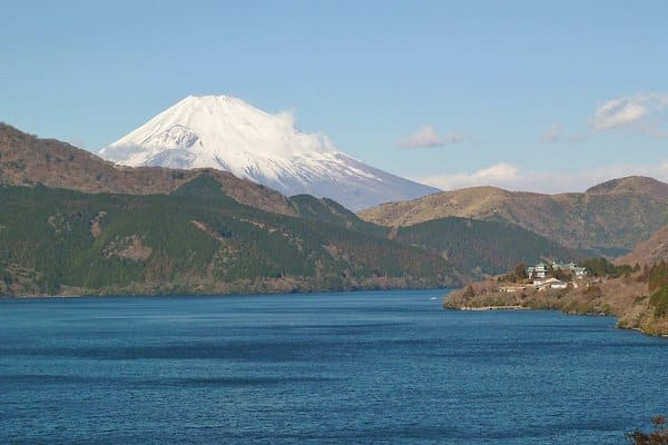
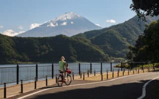
Some of the best running options in Fuji-Hakone-Izu National Park are in the Hakone area, centered on Lake Ashinoko (Lake Ashi). The large crater lake is known for its shrines, hiking paths to Mt. Hakone & Mt. Mikuni, and the historic Old Tōkaidō Road. Here are our running recommendations:
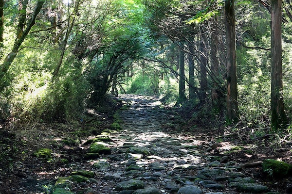
Old Tōkaidō Road. Flickr Kabacchi
Onshi-Hakone Park & Old Tōkaidō Road. At the southeastern end of the lake, Onshi-Hakone Park is located on a former imperial palace complex and features scenic walking trails and great views of the lake & surrounding mountains. A loop of the trails ~1.5 km. From there, access Old Tōkaidō Road — the historic highway which linked Tokyo with Kyoto during the feudal Edo Period. It is now a preserved walking trail, in sections. From Onshi-Hakone Park, the path goes through beautiful woodland, featuring 400 year old cedars. The surface varies from smooth dirt to stairs to some sections of the preserved stones from the original highway. It’s up to 6 km east to Hatajuku. The first 1.5 km is uphill, and the remaining 4.5 km is steady downhill. Note: the large stones in parts can be a challenge for running.ROUTE MAP
Hakone Yasuragi-no-mori. This nature & wildlife park overlooking Lake Ashi is 2 km west of Onshi-Hakone Park. One can put together a nice ~4 km loop here, combining some of the nature trails, a 1 km wooded path at the end of the lake, and a section of the Old Tōkaidō Road. Note: can be combined with the above route — it’s ~1.8 km using the main road and some waterfront paths along Hakone pier. Note: hilly! ROUTE MAP
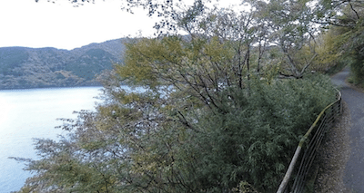
Lakeside Trail. Flickr Guilhem Vellut
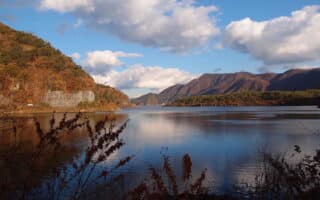
Lakeside Trail & Hakone Kuzuryu-no-mori Park. This is some of the easiest & most scenic running in Hakone. A wooded path with a packed dirt surface runs along the north/east part of the lake for 3 km between Togendai Port (Hakone Ropeway) and the Hakone Aquarium (Hakone-Komagatake Ropeway). Pretty woods and some nice lake views. Additional trails in Hakone Kuzuryu-no-mori Park. ROUTE MAP
Hakone Nature Trail. From the Hakone Visitor Centre at the northwestern end of Lake Ashi, there’s a 2 km nature trail that’s nice for running.
Trail Running Options. Some terrific hiking options here that trail runners will love. Challenging!
Mount Kamiyama and Mount Komagatake Trail. INFO & MAP
West Bank Trail. Up to 11.5 km along the western shore of Lake Ashinoko. Some sections are an easy forest trail, some sections steeper. Highlights include Kojiri and Fukara Floodgates, forest trail (especially nice in spring & autumn), some views of Mt. Komagatake, and the sandy shores of Sanadahema & Shirahama beaches. INFO & MAP
Owakudani Trail. One of the easier trail running options, as the path is wide. But it is hilly. From the Hakone Visitor Center, the trail runs for 7.5 km, using the ropeway to make a loop. Lovely trees & sulfur pools. INFO & MAP
Mt. Sengen. From Hakone-Yumoto Station, it’s 4.6 km, climbing 670m.
Mt. Mikuni. Reach this 1,100m peak from the south by the trail starting at Mori no Furai Hallor from the north via the Kojiri Pass above the Fukara watergates.
Some of the best running options in Fuji-Hakone-Izu National Park are in the Hakone area, centered on Lake Ashinoko (Lake Ashi). The large crater lake is known for its shrines, hiking paths to Mt. Hakone & Mt. Mikuni, and the historic Old Tōkaidō Road. Here are our running recommendations:
Old Tōkaidō Road. Flickr Kabacchi
Onshi-Hakone Park & Old Tōkaidō Road. At the southeastern end of the lake, Onshi-Hakone Park is located on a former imperial palace complex and features scenic walking trails and great views of the lake & surrounding mountains. A loop of the trails ~1.5 km. From there, access Old Tōkaidō Road — the historic highway which linked Tokyo with Kyoto during the feudal Edo Period. It is now a preserved walking trail, in sections. From Onshi-Hakone Park, the path goes through beautiful woodland, featuring 400 year old cedars. The surface varies from smooth dirt to stairs to some sections of the preserved stones from the original highway. It’s up to 6 km east to Hatajuku. The first 1.5 km is uphill, and the remaining 4.5 km is steady downhill. Note: the large stones in parts can be a challenge for running.ROUTE MAP
Hakone Yasuragi-no-mori. This nature & wildlife park overlooking Lake Ashi is 2 km west of Onshi-Hakone Park. One can put together a nice ~4 km loop here, combining some of the nature trails, a 1 km wooded path at the end of the lake, and a section of the Old Tōkaidō Road. Note: can be combined with the above route — it’s ~1.8 km using the main road and some waterfront paths along Hakone pier. Note: hilly! ROUTE MAP
Lakeside Trail. Flickr Guilhem Vellut
Lakeside Trail & Hakone Kuzuryu-no-mori Park. This is some of the easiest & most scenic running in Hakone. A wooded path with a packed dirt surface runs along the north/east part of the lake for 3 km between Togendai Port (Hakone Ropeway) and the Hakone Aquarium (Hakone-Komagatake Ropeway). Pretty woods and some nice lake views. Additional trails in Hakone Kuzuryu-no-mori Park. ROUTE MAP
Hakone Nature Trail. From the Hakone Visitor Centre at the northwestern end of Lake Ashi, there’s a 2 km nature trail that’s nice for running.
Trail Running Options. Some terrific hiking options here that trail runners will love. Challenging!
Mount Kamiyama and Mount Komagatake Trail. INFO & MAP
West Bank Trail. Up to 11.5 km along the western shore of Lake Ashinoko. Some sections are an easy forest trail, some sections steeper. Highlights include Kojiri and Fukara Floodgates, forest trail (especially nice in spring & autumn), some views of Mt. Komagatake, and the sandy shores of Sanadahema & Shirahama beaches. INFO & MAP
Owakudani Trail. One of the easier trail running options, as the path is wide. But it is hilly. From the Hakone Visitor Center, the trail runs for 7.5 km, using the ropeway to make a loop. Lovely trees & sulfur pools. INFO & MAP
Mt. Sengen. From Hakone-Yumoto Station, it’s 4.6 km, climbing 670m.
Mt. Mikuni. Reach this 1,100m peak from the south by the trail starting at Mori no Furai Hallor from the north via the Kojiri Pass above the Fukara watergates.
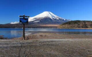
The path along Lake Yamanakako is the best spot in the Mount Fuji area for longer run that's not a trail run. Wonderful views of the lake and Mount Fuji. Dedicated multi-use path most of the way. Northern end of the lake is prettiest. Full loop is 13.4 km.
The best section for running at Lake Kawaguchi is a 6.4 km section that includes Yagizaki Park, Kawaguchiko Bridge, the museum area, Nagasaki Park, and Oishi Park. Great lake & mountain views. Other parts of the lakeside road lack a sidewalk/shoulder.
One of the Fuji Five Lakes. The best section for running is 2.2 km along the 710 Road at the south end, which features a wide shoulder and great lake & mountain views. Other sections of the 10.6 km perimeter road are pretty, but lack a sidewalk/shoulder.
Share your feedback on this route and see that of other Great Runs users. Click on the image icon to upload a photo. And please let us know if there are notes or changes we should incorporate!

Review or Comment on This Route/Share a Photo!
Share your feedback on this route and see that of other Great Runs users. Click on the image icon to upload a photo. And please let us know if there are notes or changes we should incorporate!