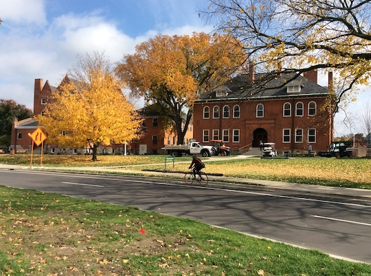
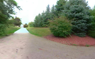
Michigan State University, in addition to being a large research university and having great sports teams, is also a great university campus for running. There are several miles of riverfront trail, a running track, arboretum, 100 miles of sidewalks, and access to quiet farm roads just south of campus.
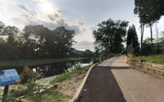
MSU River Trail. Google Street View
This website offers several specific routes suggestions, and this campus jogging map has some loop recommendations. There are many options to create your own route.
A good place to start is the Spartan Statue, warming up with a couple of laps around the running track just south of there at Ralph Young Field.
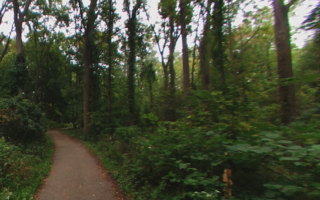
There are 3 miles of running along the Red Cedar River: From S Harrison Rd. headed west, it’s 1.1 miles along the MSU River Trail (separate paths for bicycles & pedestrians), 0.7 miles on the Sanford Woodlot Trail, and 1.2 miles along the MSU to Lake Lansing Trail, ending at Grand River Ave. There’s also some trail on the river’s north bank.
The heart of campus and its academic buildings is ~1.7 miles between S Harrison Rd. & Hagadorn Rd. west to east, and ~1.0 mile north-south between the river and the train tracks
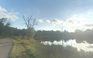
South of Mt Hope Rd., there’s a good network of flat, scenic farm roads. Note:no sidewalk & narrow shoulder, though not heavily trafficked. Power Line Dr. which runs east-west is a dirt road and quieter.
Add-Ons: The Lansing River Trail’s eastern end is at the MSU campus. You can continue west for 5 miles to Moores Park, and also connect to northern & southern spurs of the LRT.
Michigan State University, in addition to being a large research university and having great sports teams, is also a great university campus for running. There are several miles of riverfront trail, a running track, arboretum, 100 miles of sidewalks, and access to quiet farm roads just south of campus.
MSU River Trail. Google Street View
This website offers several specific routes suggestions, and this campus jogging map has some loop recommendations. There are many options to create your own route.
A good place to start is the Spartan Statue, warming up with a couple of laps around the running track just south of there at Ralph Young Field.
There are 3 miles of running along the Red Cedar River: From S Harrison Rd. headed west, it’s 1.1 miles along the MSU River Trail (separate paths for bicycles & pedestrians), 0.7 miles on the Sanford Woodlot Trail, and 1.2 miles along the MSU to Lake Lansing Trail, ending at Grand River Ave. There’s also some trail on the river’s north bank.
The heart of campus and its academic buildings is ~1.7 miles between S Harrison Rd. & Hagadorn Rd. west to east, and ~1.0 mile north-south between the river and the train tracks
South of Mt Hope Rd., there’s a good network of flat, scenic farm roads. Note:no sidewalk & narrow shoulder, though not heavily trafficked. Power Line Dr. which runs east-west is a dirt road and quieter.
Add-Ons: The Lansing River Trail’s eastern end is at the MSU campus. You can continue west for 5 miles to Moores Park, and also connect to northern & southern spurs of the LRT.
Scroll Down For Route Maps
Essentials
Create your own route. Many miles possible!
Depends on route/section chosen. Spartan Statue is a good starting point, as is the Visitor Center
The 20+ mile Lansing Trail is the anchor of running in Lansing, with numerous sections. This route follows the Grand River and Red Cedar river for up to 5 miles between Moores Park & the MSU Campus. Nice river views, numerous add-on options.
A lovely section of the Lansing River Trail. From near downtown at River Point Park, head east along the Red Cedar River for 1.7 miles, then south for 3 miles to E Jolly Rd., passing through Scott Woods Park & Hawk Island Park. Combo of open & wooded.
A fun route combining the northern Grand River section of the Lansing River Trail with a downtown spur to the Capitol area, featuring numerous important buildings and landmarks. Choose a section or do the whole ~7.5 mile route! Good add-on options.
A pleasant run along Moores River Dr., which features lovely older homes and glimpses of the Grand River. Includes a ~1 mile loop around fields & rose garden of Frances Park. Can add w/Lansing River Trail from Moores Park.
Nice off-road run in East Lansing. The Inter Urban Pathway is a paved multi-use path that runs for 1.8 miles between Burcham Dr. and Marsh Rd. Do the out & back or make it a 5.1 mile loop incorporating Nancy Moore/South Central Park.
Some good trail running options within a few miles of downtown Lansing include the Fenner Nature Center, Lake Lansing Park North, Meridian Riverfront Park, and Padgett Park. We have trail maps for each.
Share your feedback on this route and see that of other Great Runs users. Click on the image icon to upload a photo. And please let us know if there are notes or changes we should incorporate!
Subscribe
0 Comments
Oldest
Newest
Inline Feedbacks
View all comments
Essentials
Create your own route. Many miles possible!
Depends on route/section chosen. Spartan Statue is a good starting point, as is the Visitor Center


Review or Comment on This Route/Share a Photo!
Share your feedback on this route and see that of other Great Runs users. Click on the image icon to upload a photo. And please let us know if there are notes or changes we should incorporate!