The centerpiece of running in Kamloops is the series of trails along the Thompson River, called the Rivers Trail in parts. This route is focused on the ~13 km of trails along the South Thompson River and the North Thompson River, which we’ve divided into two sections.
South Thompson River. This section runs between Exhibition Park and the Overlanders Bridge. It’s 3.3 km along a paved, lit path with nice water views. The Riverside Park section is a highlight. It’s just south of the train tracks from downtown. On a nice day, there’s lots of folks along this trail and a festive scene. Access from downtown: use 10th St./River Ave., 3rd Ave., or 1st Ave.
North Thompson River section. Google Street View
North Thompson River. Cross the Overlanders Bridge (0.5 km, good sidewalk), and continue on a paved multi-use trail along the North Thompson River, paralleling Schubert Dr. There are nice river & mountain views. It’s 4.5 km from the bridge to the end of the trail at the north end of Schubert Dr.
It’s possible to continue for 2.2 km section on Westsyde Rd. (decent sidewalk, not that pretty), then pick up a gravel path along the river for 2.3 km north to Westsyde Centennial Park.
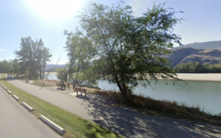
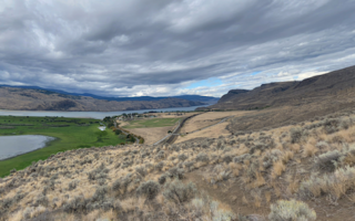
The centerpiece of running in Kamloops is the series of trails along the Thompson River, called the Rivers Trail in parts. This route is focused on the ~13 km of trails along the South Thompson River and the North Thompson River, which we’ve divided into two sections.
South Thompson River. This section runs between Exhibition Park and the Overlanders Bridge. It’s 3.3 km along a paved, lit path with nice water views. The Riverside Park section is a highlight. It’s just south of the train tracks from downtown. On a nice day, there’s lots of folks along this trail and a festive scene. Access from downtown: use 10th St./River Ave., 3rd Ave., or 1st Ave.
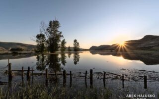
North Thompson River section. Google Street View
North Thompson River. Cross the Overlanders Bridge (0.5 km, good sidewalk), and continue on a paved multi-use trail along the North Thompson River, paralleling Schubert Dr. There are nice river & mountain views. It’s 4.5 km from the bridge to the end of the trail at the north end of Schubert Dr.
It’s possible to continue for 2.2 km section on Westsyde Rd. (decent sidewalk, not that pretty), then pick up a gravel path along the river for 2.3 km north to Westsyde Centennial Park.
Scroll Down For Route Maps
Essentials
Up to 12.8 km (8 miles) one-way; South Thompson River section is 3.3 km; North Thompson River section is up to 9.5 km
Fairly flat, with some elevation gain at northern end
Depends on section chosen. Riverside Park or Overlands Bridge is a good starting point.
Depends on section chosen. Accessible from downtown.
Island Park with a 3 km perimeter path around sports fields and along the river, with some nice views. Can also use Rivers Trail from central Kamloops to make it a longer run.
A pleasant, off-road run the area of the Kamloops Airport & Cinnamon Ridge. Up to 10k out & back on this wide, gravel trail, passing by farmland and featuring some nice mountain views.
Scenic city park in the Lower Sahali part of southern Kamloops. Some lovely sections of open grasslands. 10 km of hilly trails, ranging from easy to challenging. The paved, 1.7 Xget’tem’ Trail is a good option, and a hill workout. Lit at night!
A wonderful spot for some trail running. At 800 hectares, it's the largest municipal park in BC, with 40 km of trails. There's something for everyone here, ranging from easy to challenging. Great views of Kamloops & surrounding mountains.
Very scenic area for trial running through varied landscape of grassland vistas, cliffs and canyons, small lakes, and wooded sections with ponderosa pines and aspens. Wildflowers in spring. 4-5 designated trails, moderate to challenging.
Share your feedback on this route and see that of other Great Runs users. Click on the image icon to upload a photo. And please let us know if there are notes or changes we should incorporate!
Subscribe
0 Comments
Oldest
Newest
Inline Feedbacks
View all comments
Essentials
Up to 12.8 km (8 miles) one-way; South Thompson River section is 3.3 km; North Thompson River section is up to 9.5 km
Fairly flat, with some elevation gain at northern end
Depends on section chosen. Riverside Park or Overlands Bridge is a good starting point.
Depends on section chosen. Accessible from downtown.


Review or Comment on This Route/Share a Photo!
Share your feedback on this route and see that of other Great Runs users. Click on the image icon to upload a photo. And please let us know if there are notes or changes we should incorporate!