The highlight of running on the right bank of the Danube River is an exploration of the Petrovaradin Fortress. Nicknamed the “Gibraltar on the Danube”, the 17th-century fortress features has numerous tunnels and 16 km of preserved underground corridors. It’s a popular visitor site and there are guided tours. The Fortress is also a good spot for running, with a ~2 km loop around perimeter paths & roads, and also some stairs. It’s a scenic, park-like area, with some great views.
Fortress Wall. Google Street View.
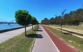
Kamenički Put North. We also suggest incorporating Kamenički Put (put=road) in your run. Headed north of the Fortress, there’s some nice running along the river, and then a short wooded section. This part is 2-3 km, so combining these two is a 7.5 km run.
Kamenički Put South. You can also head south on Kamenički Put. It’s not a dedicated waterfront path, but it’s runnable. About 0.5 km south of the Fort, a smaller road, Ribnjak donji put, runs near the water into Kamenički park, which has ~1 km of trails. You can continue south of the park for another 0.8 km. This section can be up to 8k out & back.
Add-On: Danube Left Bank. Use New Žeželj Bridge to add on with our Danube Left Bank route.
The highlight of running on the right bank of the Danube River is an exploration of the Petrovaradin Fortress. Nicknamed the “Gibraltar on the Danube”, the 17th-century fortress features has numerous tunnels and 16 km of preserved underground corridors. It’s a popular visitor site and there are guided tours. The Fortress is also a good spot for running, with a ~2 km loop around perimeter paths & roads, and also some stairs. It’s a scenic, park-like area, with some great views.
Fortress Wall. Google Street View.
Kamenički Put North. We also suggest incorporating Kamenički Put (put=road) in your run. Headed north of the Fortress, there’s some nice running along the river, and then a short wooded section. This part is 2-3 km, so combining these two is a 7.5 km run.
Kamenički Put South. You can also head south on Kamenički Put. It’s not a dedicated waterfront path, but it’s runnable. About 0.5 km south of the Fort, a smaller road, Ribnjak donji put, runs near the water into Kamenički park, which has ~1 km of trails. You can continue south of the park for another 0.8 km. This section can be up to 8k out & back.
Add-On: Danube Left Bank. Use New Žeželj Bridge to add on with our Danube Left Bank route.
Scroll Down For Route Maps
Essentials
Choose your distance. Fortress loop is 2-3 km, then there are ~7 km on Kamenički Put & Ribnjak donji put
The well-developed paths along the left bank of the Danube are the best places to run in Novi Sad. Up to 5.6 km one-way, with splendid water views, numerous parks, and easy access from the historic centre. Good add-on options.
Our 'runseeing' tour of Novi Sad has a nice amount of variety: the historic centre, Danube River path, two parks, the campus of Novi Sad University, and the option for two running tracks! Can add with more riverside paths, or the city's wide boulevards.
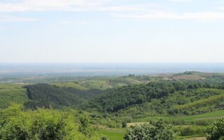
Large national park located a 30 minute drive from Novi Sad offers some terrific trail running opportunities. Fields, orchards, forests, vineyards, and 16 medieval monasteries! Fairly hilly and challenging. Good info page w/trail options & GPX files.
Share your feedback on this route and see that of other Great Runs users. Click on the image icon to upload a photo. And please let us know if there are notes or changes we should incorporate!
Subscribe
0 Comments
Oldest
Newest
Inline Feedbacks
View all comments
Essentials
Choose your distance. Fortress loop is 2-3 km, then there are ~7 km on Kamenički Put & Ribnjak donji put


Review or Comment on This Route/Share a Photo!
Share your feedback on this route and see that of other Great Runs users. Click on the image icon to upload a photo. And please let us know if there are notes or changes we should incorporate!