There are some excellent trail running options in Redding. This site is a good resource. Below are some of the our favorite easy to moderate trail runs in Redding. See the overview map for locations.
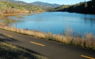
Clear Creek Greenway. 3.5 miles one-way. Gravel trail follows Clear Creek, southwest of Redding. Numerous access points off Clear Creek Rd., west of Highway 273. A highlight is the Clear Creek Gorge Overlook. TRAIL MAP
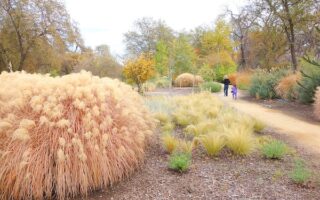
Lema Ranch Trails. 3.5 miles one-way. Nice series of trails east of Redding, with easy paths among orchards, and views of mountains. Located south of CA-299 and west of Shasta View Dr. There are 4 miles of trails, achieved through three marked loops: Secluded Loop (.75m), Leah’s Loop (1.75m), and Mule Loop (2.25m). Access: 603 Armando Ave, Redding, CA 96003.
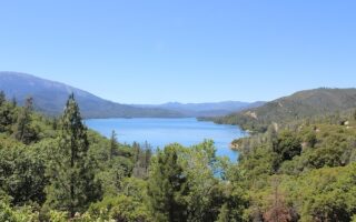
Shasta Dam Area. Hilly, scenic trails in the area of Shasta Dam. Start with the 0.6 mile Shasta Dam Access Rd., accessible from the Visitor Center. Fantastic views of the dam, and a decent sidewalk. Northwest of the dam, there are fire roads and trails, including the Dry Creek Trail. South of the dam off Walker Mine Rd., access the very challenging trail in the Chamise Peak area. EXTENSIVE TRAIL INFO & MAP
There are some excellent trail running options in Redding. This site is a good resource. Below are some of the our favorite easy to moderate trail runs in Redding. See the overview map for locations.
Clear Creek Greenway. 3.5 miles one-way. Gravel trail follows Clear Creek, southwest of Redding. Numerous access points off Clear Creek Rd., west of Highway 273. A highlight is the Clear Creek Gorge Overlook. TRAIL MAP
Lema Ranch Trails. 3.5 miles one-way. Nice series of trails east of Redding, with easy paths among orchards, and views of mountains. Located south of CA-299 and west of Shasta View Dr. There are 4 miles of trails, achieved through three marked loops: Secluded Loop (.75m), Leah’s Loop (1.75m), and Mule Loop (2.25m). Access: 603 Armando Ave, Redding, CA 96003.
Shasta Dam Area. Hilly, scenic trails in the area of Shasta Dam. Start with the 0.6 mile Shasta Dam Access Rd., accessible from the Visitor Center. Fantastic views of the dam, and a decent sidewalk. Northwest of the dam, there are fire roads and trails, including the Dry Creek Trail. South of the dam off Walker Mine Rd., access the very challenging trail in the Chamise Peak area. EXTENSIVE TRAIL INFO & MAP

Review or Comment on This Route/Share a Photo!
Share your feedback on this route and see that of other Great Runs users. Click on the image icon to upload a photo. And please let us know if there are notes or changes we should incorporate!