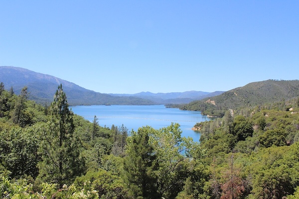
Whiskeytown National Recreation area, located 15 miles west of Redding, borders Whiskeytown Lake. The best running options are on their ~80 miles of mainly forested trails & fire/logging roads, which feature rugged canyons and waterfalls, historic mining features, and post-fire ecology. See below for some of the best trail & road running options. There are also some road running options, though scenic JFK Memorial Drive, which run along the lake in parts, doesn’t feature a sidewalk or shoulder and is NOT recommended for running.
Trail Running Options
This page has excellent information on the trail running options. The trains range from easy to very challenging, Some of the easier trails for running are:
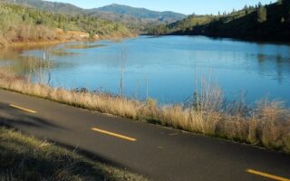
Oak Bottom Water Ditch Trail: A flat, 2.75-mile lakeshore trail, perfect for birdwatching and enjoying views of the Clear Creek Arm of Whiskeytown Lake.
Clear Creek Canal. Partially shaded, mostly flat trail paralleling historic water ditch dating from the California Gold Rush era. Access from Mount Shasta Mine Loop Trailhead.
There are also some hikes along old logging roads that are steep and challenging, but good for running because the footing is easier. See the ‘challenging hike’ section on the Whiskeytown NRA trail info page.
Road Running Options
Unfortunately, scenic JFK Memorial Drive, which run along the lake in parts, doesn’t feature a sidewalk or shoulder and is NOT recommended for running. Same for Paige Bar Road. According to Park rangers, “these are paved and winding roadways through park areas with numerous blind curves where people can unfortunately be speeding”. The best road running options in Whiskeytown NRA are:
South Shore Drive. Probably the best option. While it’s is open to vehicles, according to a park ranger “there is not heavy traffic on it. It is gravel, narrow, and winding, and a great opportunity for a run”. The road runs for ~6.4 miles between Brandy Creek and Judge Francis Carr Powerhouse, gaining 738 feet from south to north (two major climbs). Boulder Creek Trail is at the ~3.7 mile mark, heading north.
Brandy Creek Road “would be another similar road with not a ton of traffic”. It’s 2.7 miles from Brandy Creek to Sheep Camp, and fairly flat. From Sheep Camp, the road continues for another 5.5 miles to the peak of Shasta Bally — but it is a STEEP CLIMB, rising 4,000+ feet. Note the section between Sheep Camp & Shasta Bally is closed in winter.
Runners should be on the lookout however for oncoming vehicles if they use these road options.
Whiskeytown National Recreation area, located 15 miles west of Redding, borders Whiskeytown Lake. The best running options are on their ~80 miles of mainly forested trails & fire/logging roads, which feature rugged canyons and waterfalls, historic mining features, and post-fire ecology. See below for some of the best trail & road running options. There are also some road running options, though scenic JFK Memorial Drive, which run along the lake in parts, doesn’t feature a sidewalk or shoulder and is NOT recommended for running.
Trail Running Options
This page has excellent information on the trail running options. The trains range from easy to very challenging, Some of the easier trails for running are:
Oak Bottom Water Ditch Trail: A flat, 2.75-mile lakeshore trail, perfect for birdwatching and enjoying views of the Clear Creek Arm of Whiskeytown Lake.
Clear Creek Canal. Partially shaded, mostly flat trail paralleling historic water ditch dating from the California Gold Rush era. Access from Mount Shasta Mine Loop Trailhead.
There are also some hikes along old logging roads that are steep and challenging, but good for running because the footing is easier. See the ‘challenging hike’ section on the Whiskeytown NRA trail info page.
Road Running Options
Unfortunately, scenic JFK Memorial Drive, which run along the lake in parts, doesn’t feature a sidewalk or shoulder and is NOT recommended for running. Same for Paige Bar Road. According to Park rangers, “these are paved and winding roadways through park areas with numerous blind curves where people can unfortunately be speeding”. The best road running options in Whiskeytown NRA are:
South Shore Drive. Probably the best option. While it’s is open to vehicles, according to a park ranger “there is not heavy traffic on it. It is gravel, narrow, and winding, and a great opportunity for a run”. The road runs for ~6.4 miles between Brandy Creek and Judge Francis Carr Powerhouse, gaining 738 feet from south to north (two major climbs). Boulder Creek Trail is at the ~3.7 mile mark, heading north.
Brandy Creek Road “would be another similar road with not a ton of traffic”. It’s 2.7 miles from Brandy Creek to Sheep Camp, and fairly flat. From Sheep Camp, the road continues for another 5.5 miles to the peak of Shasta Bally — but it is a STEEP CLIMB, rising 4,000+ feet. Note the section between Sheep Camp & Shasta Bally is closed in winter.
Runners should be on the lookout however for oncoming vehicles if they use these road options.

Review or Comment on This Route/Share a Photo!
Share your feedback on this route and see that of other Great Runs users. Click on the image icon to upload a photo. And please let us know if there are notes or changes we should incorporate!