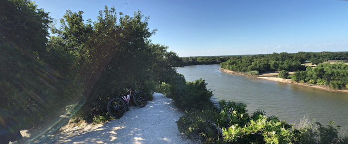
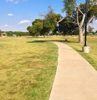
The 416-acre Cameron Park is the other signature running spot in Waco. This National Recreation Trail is a green oasis, featuring 26 miles of meandering paths, featuring gorgeous trees, two riverbanks, and scenic cliffs. There’s something for every runner here: easier, more park-like trails, and more rugged trail running options. This TRAIL MAP is a helpful resource, showing trail ratings from easy to advanced, and the Cameron Park app has more information on the various trail loop options. PRO TIP: Good shade option on a hot day.
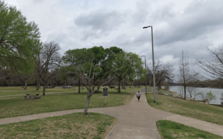
Easier options are the ~2 miles of the Waco Riverwalk trail that pass through the park. This can be extended south along the west bank for a total of 5.3 miles between Cameron Park and Baylor University. Another option is to do a lopp with the Riverwalk on the East Bank and Brazos Park East, using the bridge at Herring Rd.
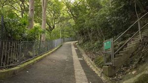
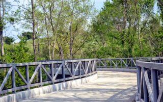
Jacobs Ladder. CC 4.0
Trail Running: The interior trails are windy, and can be rugged and challenging. There are trails that zigzag up 100-foot bluffs to overlook the rivers. Get the heart rate up on Jacobs Ladder! NOTE: The interior trail system is windy and confusing. And keep an eye out for mountain bikers. The Cameron Park app can be helpful here.
The 416-acre Cameron Park is the other signature running spot in Waco. This National Recreation Trail is a green oasis, featuring 26 miles of meandering paths, featuring gorgeous trees, two riverbanks, and scenic cliffs. There’s something for every runner here: easier, more park-like trails, and more rugged trail running options. This TRAIL MAP is a helpful resource, showing trail ratings from easy to advanced, and the Cameron Park app has more information on the various trail loop options. PRO TIP: Good shade option on a hot day.
Easier options are the ~2 miles of the Waco Riverwalk trail that pass through the park. This can be extended south along the west bank for a total of 5.3 miles between Cameron Park and Baylor University. Another option is to do a lopp with the Riverwalk on the East Bank and Brazos Park East, using the bridge at Herring Rd.
Jacobs Ladder. CC 4.0
Trail Running: The interior trails are windy, and can be rugged and challenging. There are trails that zigzag up 100-foot bluffs to overlook the rivers. Get the heart rate up on Jacobs Ladder! NOTE: The interior trail system is windy and confusing. And keep an eye out for mountain bikers. The Cameron Park app can be helpful here.
Scroll Down For Route Maps
Essentials
26 miles of trails. Riverwalk section is 2 miles
Interior trails can be hillier, climnbing to 100 feet
The paths along the Brazos River -- dubbed the Waco Riverwalk -- are the signature run in Waco. Paved paths line the east & west banks of the river between Baylor University and Cameron Park, with nice water views and several riverfront parks. Good loop options.
We've mapped a nice 5-miler around the Baylor University campus, incorporating wide pedestrian paths passing by its main buildings, designated walk/run trails, and a terrific running track in the Baylor Basin area. Add with the Waco Riverwalk along the Brazos River.
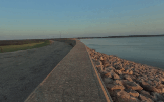
Nice run on a paved multi-use path above Waco Lake/Dam, which is located 6 miles northwest of downtown Waco. Nice water views, but note it's open & exposed. Full out & back is 6 miles. Add with road/paths in adjacent Airport Park.
Nice park for running at the south end of Lake Waco. There's a 1-mile trail along the lake, and ~5 miles of interior trail running trails passing through woods and scrub land.
A nice 5-miler on a paved multi-use path in the Harris Hill neighborhood on the west side of Waco. Landscape is open with fields and some nice trees along the way. The bridge over the Bosque River is a scenic highlight.
Share your feedback on this route and see that of other Great Runs users. Click on the image icon to upload a photo. And please let us know if there are notes or changes we should incorporate!
Subscribe
0 Comments
Oldest
Newest
Inline Feedbacks
View all comments
Essentials
26 miles of trails. Riverwalk section is 2 miles
Interior trails can be hillier, climnbing to 100 feet


Review or Comment on This Route/Share a Photo!
Share your feedback on this route and see that of other Great Runs users. Click on the image icon to upload a photo. And please let us know if there are notes or changes we should incorporate!