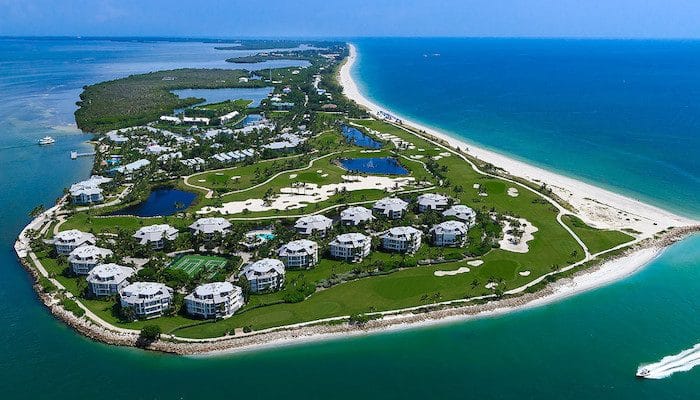
Sanibel/Captiva islands are about 15 miles south of Fort Myers and 45 miles north of Naples. They are popular visitor destinations. Sanibel is reached by a dramatic causeway from the mainland. It is quite undeveloped, with a huge part of the island conserved as part of the JN Ding Darling Wildlife Refuge. From the causeway, it is about 10 miles down island to Captiva, which is even more remote, un-developed, and pristine. The northern 2 miles of Capitva, toward the tip, is privately owned by the South Seas resort, although one can run on the beach!
There is some terrific running on Sanibel/Capitva. Rather than provide information on a specific route, here are our recommendations:
Run the bike paths. See this interactive map. There are 22 miles of bike paths on Sanibel, mainly paralleling the road. Note there aren’t really ocean water views most of the way. The most seamless section is Sanbel-Captiva Rd., heading north for 7 miles from Rabbit Rd.m to Blind Pass (Bridge to Captiva). Distance segments.
Captiva Dr.: The 3.2 miles on from Blind Pass Bridge crossing over to Captiva, to the South Seas Resort is very pretty, with a combination of open areas with and pleasant foliage. Combination of bike path and shoulder on the road (narrow in spots). The nicest section is the 1 mile section along the water, just south of the Green Flash, with ocean views.
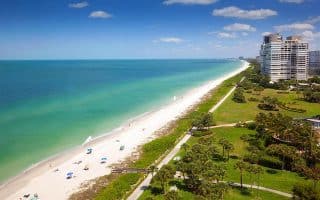
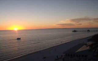
Running on the beach. The nearly 15-mile continuous beach is runnable, depending on tides and conditions. Best at low-ish tide. Sloped in sections. Watch for shells! This is about as pristine and undeveloped as beach gets in Florida. A great section is the 5 miles from Blind Pass (Captiva Bridge) to the northern tip. Parking can be a bit of a challenge in Captiva. There are designated parking spots on Sanibel (Bowmans, Tarpon, Lighthouse are some of the largest lots). The widest sections of the beach are from Bowmans to Rabbit Rd. A special treat at sunset!
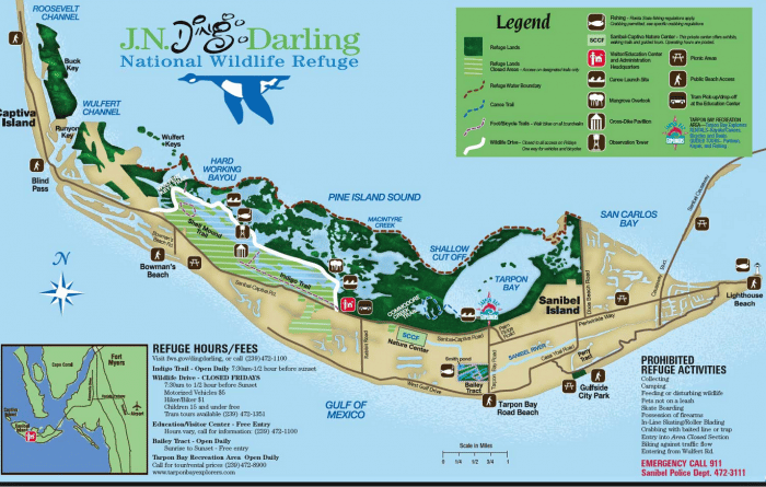
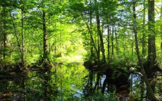
Wildlife Refuge. There are several sections of the Wildlife Refuge, all over the island, with trails for walking/biking/running. A favorite option is the 4 mile loop road from the main Refuge entry point (see map). This are wonderful spots along here for wildlife viewing. 250+ species of birds! Admission required.
South Seas Island Resort. This is a large and popular resort, spread over nearly 2 miles at the northern tip of Captiva. One must be a guest to run on the hotel grounds. The ~2 mile “Plantation Road” is popular with hotel guests, as is the ~1 mile loop around the perimeter of the golf course. Combine the road with the beach for a nice run.
Wulfert Rd. A quieter road option, running 2 miles through a residential neighborgood from its start off the Refuge to the end.
Note: Running/walking is NOT permitted on the causeway between Ft. Myers and Sanibel (although biking is).
Sanibel/Captiva islands are about 15 miles south of Fort Myers and 45 miles north of Naples. They are popular visitor destinations. Sanibel is reached by a dramatic causeway from the mainland. It is quite undeveloped, with a huge part of the island conserved as part of the JN Ding Darling Wildlife Refuge. From the causeway, it is about 10 miles down island to Captiva, which is even more remote, un-developed, and pristine. The northern 2 miles of Capitva, toward the tip, is privately owned by the South Seas resort, although one can run on the beach!
There is some terrific running on Sanibel/Capitva. Rather than provide information on a specific route, here are our recommendations:
Run the bike paths. See this interactive map. There are 22 miles of bike paths on Sanibel, mainly paralleling the road. Note there aren’t really ocean water views most of the way. The most seamless section is Sanbel-Captiva Rd., heading north for 7 miles from Rabbit Rd.m to Blind Pass (Bridge to Captiva). Distance segments.
Captiva Dr.: The 3.2 miles on from Blind Pass Bridge crossing over to Captiva, to the South Seas Resort is very pretty, with a combination of open areas with and pleasant foliage. Combination of bike path and shoulder on the road (narrow in spots). The nicest section is the 1 mile section along the water, just south of the Green Flash, with ocean views.
Running on the beach. The nearly 15-mile continuous beach is runnable, depending on tides and conditions. Best at low-ish tide. Sloped in sections. Watch for shells! This is about as pristine and undeveloped as beach gets in Florida. A great section is the 5 miles from Blind Pass (Captiva Bridge) to the northern tip. Parking can be a bit of a challenge in Captiva. There are designated parking spots on Sanibel (Bowmans, Tarpon, Lighthouse are some of the largest lots). The widest sections of the beach are from Bowmans to Rabbit Rd. A special treat at sunset!
Wildlife Refuge. There are several sections of the Wildlife Refuge, all over the island, with trails for walking/biking/running. A favorite option is the 4 mile loop road from the main Refuge entry point (see map). This are wonderful spots along here for wildlife viewing. 250+ species of birds! Admission required.
South Seas Island Resort. This is a large and popular resort, spread over nearly 2 miles at the northern tip of Captiva. One must be a guest to run on the hotel grounds. The ~2 mile “Plantation Road” is popular with hotel guests, as is the ~1 mile loop around the perimeter of the golf course. Combine the road with the beach for a nice run.
Wulfert Rd. A quieter road option, running 2 miles through a residential neighborgood from its start off the Refuge to the end.
Note: Running/walking is NOT permitted on the causeway between Ft. Myers and Sanibel (although biking is).
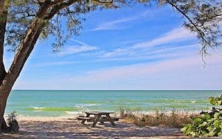
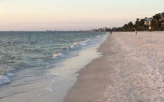
The best beachside running in the heart of Naples. Starting at Lowedermilk Park, and running south along Gulf Shore Drive and Gordon Drive, it is about 4.5 miles one way.
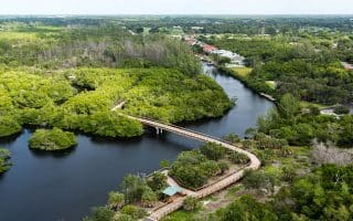
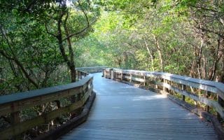
The paths and boardwalk around the Gordon River are like taking a run through the Everglades. Elevated boardwalk sections over wetlands, where you can watch for birds, tortoises, and other wildlife.
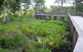
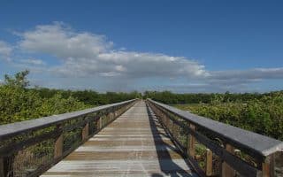
A great add-on to the Gordon River Greenway. It’s just to the north of the Greenway. There are about 2 miles of pedestrian-only trails, mainly a boardwalk going over a swampy area.
A run along Pelican Bay Blvd., 7 miles north of downtown Naples, is a great way to experience the waterfront, lovely foliage, and gorgeous Florida homes.
A popular beach access points.The boardwalk runs through a mangrove forest of salt-tolerant red, white and black mangroves. It also has a tidal bay area.
This barrier island is one of the loveliest spots in southwest Florida. Our route follows the course of the Marco Island 5k, through lovely residential areas. One of the hillier runs in S. Florida.
The Bird Rookery Swamp Trail is 25 miles north of Naples, and offers 12 miles of hiking and biking trails. Starts with a 1500-ft. boardwalk, then becomes ground level, with swamp on both sides.
Seven miles of beach running heaven on Estero Island. Cross the bridge, find a parking place, and enjoy running this wide, flat beach. Can be combined with 5 miles of trails at Lovers Key State Park at the southern end.
Seven miles of beach running heaven on Estero Island. Cross the bridge, find a parking place, and enjoy running this wide, flat beach. Can be combined with 5 miles of trails at Lovers Key State Park at the southern end.
Wonderful beach running in area between Ft. Myers & Naples. Bonita Beach is 2.5 miles and adjoining Barefoot Beach is ~3 miles. Scenic and flat, generally good sand for running. Can also run on Hickory Blvd. & Barefoot Blvd. See info on private community.
A 5-mile paved, multi-use trail that runs between Six Mile Cypress in the south to Colonial Blvd. in the north. Much of the trail runs along a canal, and has some pretty sections. Southern section is most shaded
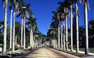
McGregor Blvd., with its palm-lined way and wide sidewalks, is popular with runners. Easy to do a straight shot from College Parkway to Midpoint Bridge or the Country Club. Whiskey Creek Dr. loop is another option.
Share your feedback on this route and see that of other Great Runs users. Click on the image icon to upload a photo. And please let us know if there are notes or changes we should incorporate!


Review or Comment on This Route/Share a Photo!
Share your feedback on this route and see that of other Great Runs users. Click on the image icon to upload a photo. And please let us know if there are notes or changes we should incorporate!