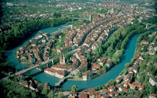
Running along the Aare is a classic European river run. We’ve mapped two routes — this one is a 7 km loop headed north from city center, using both sides of the river (there’s an extra ~1 km or so on the western side). It’s particularly charming, with wonderful views of the water, and historic buildings on both sides of the river. The southern loop is 7.6 km, headed south to the Eichholz state park. Note: (brücke=bridge)
Start at the southernmost end of the path, 0.6 km south of the Kornhausbrücke (bridge). Run north on the western side of the path for 3.5 km, reaching the Blutturm (fortress) after ~1 km, a pedestrian bridge at ~2.6 km (option here for a shorter loop), crossing under the E27 to the end. Turn around and take the pedestrian bridge to the eastern side of the river (4.5 km mark). Run south along the path, through the pretty Lorraine riverside area, enjoying the river and a tree-lined park. At the ~6 km mark, pass under the Lorraine Bridge, with the Botanical Garden on the left (it’s small, ~0.5 km of paths). Continue for another 0.5 km, crossing back over the Altenbergsteg pedestrian suspension bridge, to complete the route.
Longer Run: Connect with our southern Aare River Loop.


Review or Comment on This Route/Share a Photo!
Share your feedback on this route and see that of other Great Runs users. Click on the image icon to upload a photo. And please let us know if there are notes or changes we should incorporate!