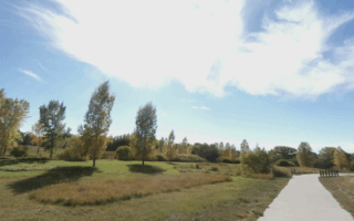
There are several miles of the 40+ mile Cheyenne Trail in the southern part of Cheyenne, into Greeley. We’ve mapped a route of 9.5 miles, but it can be broken into two sections if preferable. This route is mainly on a paved multi-use path through residential areas. It’s not the most scenic ever, but it’s a good way to get off road.
The southern part of the route starts at Laramie Community College. Follow the multi-use path west along Allison Draw stream for about 3 miles, into South Greeley. [Shorter Option: retrace your steps to the start]. For the longer route, head north on the trail paralleling Park Ave./Walterscheid Blvd. for ~2 miles, crossing I-80. [NOTE: Running track at South High School]. This connects to a nice, 2.5 mile loop section of the trail along Crow Creek, into David R. Romero South Cheyenne Community Park (~0.5 miles of paths here). For the return, head east along Crow Creek and then south along Morrie Ave.
Option: Divide Into Sections: The south (Greeley) and Crow Creek sections of this route can be done as separate, standalone runs.


Review or Comment on This Route/Share a Photo!
Share your feedback on this route and see that of other Great Runs users. Click on the image icon to upload a photo. And please let us know if there are notes or changes we should incorporate!