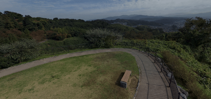
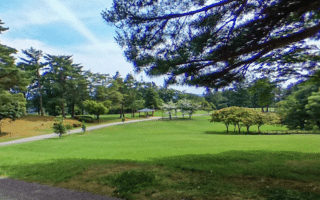
For some hills & views, head to Utatsuyama Park. Located just east of the Asano River and the Higashi Chaya District, the 141m Utatsuyama Mountain is known for its lovely views of the city and the Sea of Japan from its summit, as well as the hydrangea & iris garden located halfway up. Notes: This is a hilly run! See the map kiosks near the park entrance/parking areas. INFO
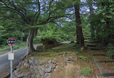
Path up Utatsuyama Mtn. Google Street View
There are a few ways to run this park. The shorter and more challenging route is to use the paths, which also include a fair number of stairs. From the Ponte Tenjin Bridge in Higashi Chaya District, use the twisty, wooded road to get into the park. Connect to the paths, which also include lots of stairs. It’s a There’s also a road, which lacks a shoulder in parts. A better road, with a decent shoulder, is the one leading to the 400 Year Forest. The hydrangea & iris garden has its peak bloom mid-June to mid-July.
To extend the route, run on the road to the 400 Year Forest at the northeast end of the park, or the Miharashidai observation deck at the southern end.
For some hills & views, head to Utatsuyama Park. Located just east of the Asano River and the Higashi Chaya District, the 141m Utatsuyama Mountain is known for its lovely views of the city and the Sea of Japan from its summit, as well as the hydrangea & iris garden located halfway up. Notes: This is a hilly run! See the map kiosks near the park entrance/parking areas. INFO
Path up Utatsuyama Mtn. Google Street View
There are a few ways to run this park. The shorter and more challenging route is to use the paths, which also include a fair number of stairs. From the Ponte Tenjin Bridge in Higashi Chaya District, use the twisty, wooded road to get into the park. Connect to the paths, which also include lots of stairs. It’s a There’s also a road, which lacks a shoulder in parts. A better road, with a decent shoulder, is the one leading to the 400 Year Forest. The hydrangea & iris garden has its peak bloom mid-June to mid-July.
To extend the route, run on the road to the 400 Year Forest at the northeast end of the park, or the Miharashidai observation deck at the southern end.
Scroll Down For Route Maps
Essentials
1.6 km (1 mile) one-way to summit from Ponte Tenjin Bridge
112m (369 feet) one-way for mapped route
Ponte Tenjin Bridge or other access points
Ponte Tenjin Bridge. Can also access from Tokiwa-machi Ryokuchi Park, or Utatsuyamamiharashidai Parking Lot
A seaside path in Hakusan, which neighbors Kanazawa. The concrete path runs for up to 10 km, from Matto Seaside Park south to Mikawa, paralleling the E8. Some nice views of the Sea of Japan. Additional paths in Matto Seaside Park.
A nice run in the waterfront section of Kanazawa. A concrete seaside path runs from Kenmin Seaside Park south for 5 km, which can be combined with interior park paths for a nice loop. Extend our Hakusan route, with 10+ km of seaside path & Matto Seaside Park.
9 km of paved multi-use paths along the Sai River are among the best places for a longer, easier off-road run in central Kanazawa. Water views, parks, numerous bridges allowing for loops, and a running track at Seibu Ryokuchi Park.
A 'runseeing' tour of Kanazawa's scenic & historic highlights: the grounds of Kanazawa Castle Park, the beautifull Kenroku-en garden, and Hirosaka Park. Especially beautiful in blossom season & autumn. Add with Sai River paths.
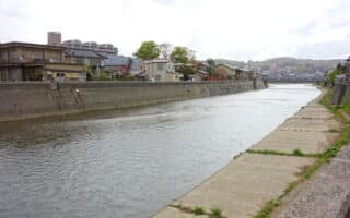
Concrete paths along the Asano River, in the Kazuemachi Chaya & Higashi Chaya districts, known for their teahouses and restored 18th-century wooden houses. Up to 5.6 km between the Asanogawa Bridge & Tagamihonmachi Asagiri Park.
Park in the Wakamatsumachi area, built on the site of a former golf course. Nice spot for a run, with 3-4 km of paths, some more open & others more wooded.
Share your feedback on this route and see that of other Great Runs users. Click on the image icon to upload a photo. And please let us know if there are notes or changes we should incorporate!
Subscribe
0 Comments
Oldest
Newest
Inline Feedbacks
View all comments
Essentials
1.6 km (1 mile) one-way to summit from Ponte Tenjin Bridge
112m (369 feet) one-way for mapped route
Ponte Tenjin Bridge or other access points
Ponte Tenjin Bridge. Can also access from Tokiwa-machi Ryokuchi Park, or Utatsuyamamiharashidai Parking Lot


Review or Comment on This Route/Share a Photo!
Share your feedback on this route and see that of other Great Runs users. Click on the image icon to upload a photo. And please let us know if there are notes or changes we should incorporate!