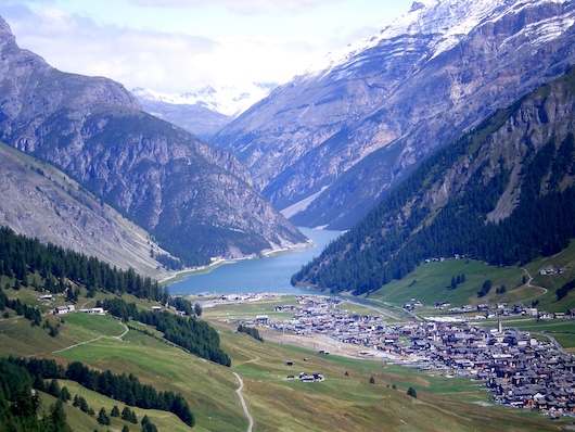
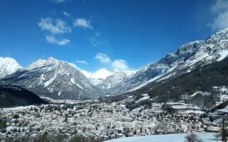
Livigno is a ski resort in the Lombardy area of the Italian Alps, near the Swiss Border. It is part of the Valtellina Cluster of the alpine events for the 2026 Milano Cortina Winter Olympic Games. Livigno is the site of Snowboarding and Freestyle Skiing events at specially built Snow Park and Aerials & Moguls Park venues.
Google Street View
There’s some gorgeous, easy running options in the valley area between the mountains, on paths along Lago Livigno (lake) and along the Spöl River. They can be run separately or combined. Overall, there’s a 20 km paved multi-use path that runs the length of the valley. In winter, the path is groomed — for both XC-skiing and also packed down for walking/running, either as a parallel path or separate ‘section’ for running. In the non-winter months, there are also myriad trail running opportunities. Note: this is high-altitude running: 1800m (6,000 feet).
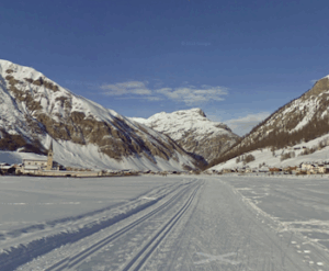
Via Restel Along Lago Livigno
V. Restel, Lago Livigno. Google Street View
The Via Restel Path along the Lago Livigno reservoir is among our most scenic running routes in the alpine clusters of the Milano Cortina games. A wide gravel path runs along the south side of the lake. Though it’s wooded, and there are trees on the lake side, there are still some lovely views of the lake and mountains. We start the route off Via Lipont, at the small bridge that crosses over the river. The path extends for 2.4 km.
Longer Option: To add to the 4.8 km out & back, there’s a path that runs along the Torrente Federia, on the Carosello side of the resort. You’ll need to cross back over the bridge and run along the north side of the Spöl for 0.8 km. The path along the stream runs for 1.7 km, climbing ~60m, and features some lovely mountain views. Doing both these options is a neat 10k! Can also mix & match with the Spöl River paths (below), which extend south for ~5.5 km.
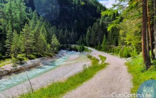
Spöl River Paths
V. Bondi, Spöl River. Google Street View
The Via Bondi cycle path runs along the Spöl River, which cuts right through the Livigno Valley, bisecting the two ski areas. Starting near Via Pemont, we’ve mapped ~5.5 km to the Parcheggio Comunale P14 @V. Pont Lonch. There are great views of the narrow river and surrounding mountains. In some sections there are paths along both sides of the river. It’s a gradual, ~60m uphill headed south. Winter Note:These paths are groomed for X-C in winter, and also packed down for walkers/runners, alongside or separate sections.
Longer Option: Combine with Lago Livigno route, above.
Livigno is a ski resort in the Lombardy area of the Italian Alps, near the Swiss Border. It is part of the Valtellina Cluster of the alpine events for the 2026 Milano Cortina Winter Olympic Games. Livigno is the site of Snowboarding and Freestyle Skiing events at specially built Snow Park and Aerials & Moguls Park venues.
Google Street View
There’s some gorgeous, easy running options in the valley area between the mountains, on paths along Lago Livigno (lake) and along the Spöl River. They can be run separately or combined. Overall, there’s a 20 km paved multi-use path that runs the length of the valley. In winter, the path is groomed — for both XC-skiing and also packed down for walking/running, either as a parallel path or separate ‘section’ for running. In the non-winter months, there are also myriad trail running opportunities. Note: this is high-altitude running: 1800m (6,000 feet).
Via Restel Along Lago Livigno
V. Restel, Lago Livigno. Google Street View
The Via Restel Path along the Lago Livigno reservoir is among our most scenic running routes in the alpine clusters of the Milano Cortina games. A wide gravel path runs along the south side of the lake. Though it’s wooded, and there are trees on the lake side, there are still some lovely views of the lake and mountains. We start the route off Via Lipont, at the small bridge that crosses over the river. The path extends for 2.4 km.
Longer Option: To add to the 4.8 km out & back, there’s a path that runs along the Torrente Federia, on the Carosello side of the resort. You’ll need to cross back over the bridge and run along the north side of the Spöl for 0.8 km. The path along the stream runs for 1.7 km, climbing ~60m, and features some lovely mountain views. Doing both these options is a neat 10k! Can also mix & match with the Spöl River paths (below), which extend south for ~5.5 km.
Spöl River Paths
V. Bondi, Spöl River. Google Street View
The Via Bondi cycle path runs along the Spöl River, which cuts right through the Livigno Valley, bisecting the two ski areas. Starting near Via Pemont, we’ve mapped ~5.5 km to the Parcheggio Comunale P14 @V. Pont Lonch. There are great views of the narrow river and surrounding mountains. In some sections there are paths along both sides of the river. It’s a gradual, ~60m uphill headed south. Winter Note:These paths are groomed for X-C in winter, and also packed down for walkers/runners, alongside or separate sections.
Longer Option: Combine with Lago Livigno route, above.
Scroll Down For Route Maps
Essentials
Lago Livigno: Up to 10 km, including lake path & Torrente; Spöl River: Up to 11 km (7 miles) out & back
This 50 km multi-use trail is best spot for a run in Cortina that's not a trail run. Enjoy classic alpine views. The path runs from Cimbanche and Pieve di Cadore, passing through Cortina. Steady downhill north to south. ~6 km near Cortina is plowed in winter.
A pleasant 7 km loop around the Boite Stream in Fiames, located 5 km north of Cortina. Mainly wooded run on a flat gravel path, with some water & mountain views. Good shade option on a hot day!
Bormio is the site of the Men's downhill and snowboarding events for the 2026 Winter Olympics. The best spot for running is the cycle path along the Adda River. Lovely water & mountain views!
The Fiemme Valley is host to nordic skiing and ski jumping events for the 2026 Winter Olympics. Best running spot is the paved cycle path that runs between between Predazzo and Molina di Fiemme, passing through Tesero.
Share your feedback on this route and see that of other Great Runs users. Click on the image icon to upload a photo. And please let us know if there are notes or changes we should incorporate!
Subscribe
0 Comments
Oldest
Newest
Inline Feedbacks
View all comments
Essentials
Lago Livigno: Up to 10 km, including lake path & Torrente; Spöl River: Up to 11 km (7 miles) out & back


Review or Comment on This Route/Share a Photo!
Share your feedback on this route and see that of other Great Runs users. Click on the image icon to upload a photo. And please let us know if there are notes or changes we should incorporate!