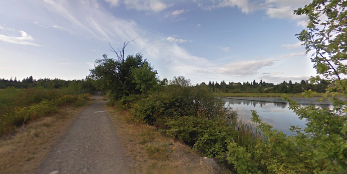
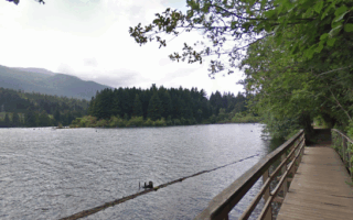
This is a fun route combining three adjacent parks in central Nanaimo: Bowen Park, Buttertubs Marsh Park, and Third Street Park. It makes for a nice ~7k loop, nearly all off road, with a variety of terrain including woods, marshes, and park fields. Each park has its own character!
Bowen Park. Google Street View
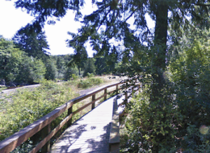
We start at Bowen Park, which is closest to downtown Nanaimo. It’s a large natural area, with mainly wooded trails. Our route follows the mainly wooded Millstone Interpretive Trail, which runs for 1.5 km from east to west through the park. It’s a firm gravel trail with a couple of boardwalk sections. There’s a waterfall and a duck pond, and the park also has a public pool and tennis courts. Option: additional trails in the park.
Exiting the western end of Bowen Park, use Buttertubs Drive for 0.5 km south into Buttertubs Marsh Park. This park is a popular bird sanctuary, with walking trails at its eastern end. Run west on the trail at the northern edge of the park for 0.5 km, connecting to a lovely gravel trail that runs for 1.7 km north-south through the park. The landscape is more open, with some lovely marsh and mountain views.
Exit the park onto Jingle Pot Rd. for 0.4 km to Third Street Park. This is a more traditional looking park, very green with some woods and ball fields, and other recreational facilities. Run the main 1 km north-south trail through the park. At the southern end, there’s a running track. Exit the park and head east along Fourth St. for 0.8 km, and then north on Howard St. for 1.4 km back to Bowen Park, to complete the loop. These roads have decent sidewalks.
Add-Ons: Additional trails in Bowen Park. Also, Matteo Sutton Park and the Harbourfont Walkway is 1 km east of Bowen Park.
This is a fun route combining three adjacent parks in central Nanaimo: Bowen Park, Buttertubs Marsh Park, and Third Street Park. It makes for a nice ~7k loop, nearly all off road, with a variety of terrain including woods, marshes, and park fields. Each park has its own character!
Bowen Park. Google Street View
We start at Bowen Park, which is closest to downtown Nanaimo. It’s a large natural area, with mainly wooded trails. Our route follows the mainly wooded Millstone Interpretive Trail, which runs for 1.5 km from east to west through the park. It’s a firm gravel trail with a couple of boardwalk sections. There’s a waterfall and a duck pond, and the park also has a public pool and tennis courts. Option: additional trails in the park.
Exiting the western end of Bowen Park, use Buttertubs Drive for 0.5 km south into Buttertubs Marsh Park. This park is a popular bird sanctuary, with walking trails at its eastern end. Run west on the trail at the northern edge of the park for 0.5 km, connecting to a lovely gravel trail that runs for 1.7 km north-south through the park. The landscape is more open, with some lovely marsh and mountain views.
Exit the park onto Jingle Pot Rd. for 0.4 km to Third Street Park. This is a more traditional looking park, very green with some woods and ball fields, and other recreational facilities. Run the main 1 km north-south trail through the park. At the southern end, there’s a running track. Exit the park and head east along Fourth St. for 0.8 km, and then north on Howard St. for 1.4 km back to Bowen Park, to complete the loop. These roads have decent sidewalks.
Add-Ons: Additional trails in Bowen Park. Also, Matteo Sutton Park and the Harbourfont Walkway is 1 km east of Bowen Park.
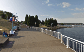
One of our two coastal routes in Nanaimo, this one showcases the Harbourfront Walkway along the Harbour, marina, and around Maffeo Sutton Park. It's 4.5 km one-way, great water views, ending at the Ferry Terminal.
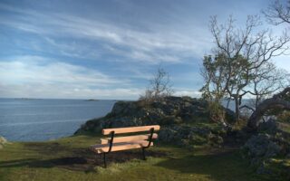
One of our two coastal routes in Nanaimo, this one in northern Nanaimo showcases Pipers Lagoon Park & Neck Point Park, with their seaside trails and views.
The 5.5 km Westwood Lake Trail loop is one of the most popular runs in Nanaimo. Westwood Lake Park is located in the foothills of Mt. Benson. It's a firm gravel trail, wooded with some lake views. Additional trails in the park.
At 19 km, the Parkway Trail is longest paved multi-use trail on Vancouver Island, and a good way to clock some miles! Not the most scenic, as it mainly parallels the Parkway Highway.
Take the 10-minute ferry to enjoy the 22 miles of trails on Saysutshun. Fairly easy running on mainly wooded trails, with some nice lookout points. Most popular for running is the 8 km Coastal Trail perimeter loop.
Share your feedback on this route and see that of other Great Runs users. Click on the image icon to upload a photo. And please let us know if there are notes or changes we should incorporate!

Review or Comment on This Route/Share a Photo!
Share your feedback on this route and see that of other Great Runs users. Click on the image icon to upload a photo. And please let us know if there are notes or changes we should incorporate!