This route is an 8k ‘runseeing’ tour of the central and historical section of Phnom Penh. It combines several parks, large plazas, and several important monuments and sights. Use our mapped route as a guideline to create your own route. Good add-on options, shown below.
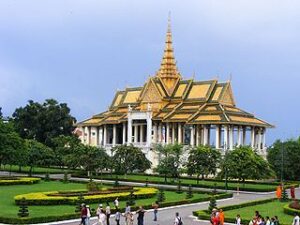
Royal Palace complex. AJ Oswald
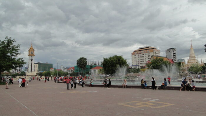
Start at the ferry terminal at the southern end of the Riverside Path. Head inland on the wide pedestrian mall alongside the Nagaworld resort to the Independence Monument. It’s 1.2 km, passing the Statue of Samdech Choun Nath, Statue of His Majesty Preah Bat. Retrace your steps for 0.5 km to connect north into Wat Botum Park, a pleasant green space with paths and wide plazas. Head north for 0.6 km through the park, then use the path along Sothearos Blvd. to the Royal Palace area, where you can enjoy jaunts around Veal Preah Meru Square & Royal Palace Park.
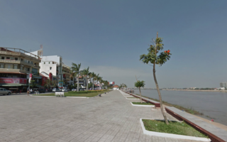
The next section is 1 km north along the Riverside Path. From the north end at the Night Market, there’s a ~2 km option to head up to the Wat Phnom Daun Penh, a Buddhist temple built on site of 14th-century pagoda. It’s the tallest religious structure in the city (~30m climb). To return to the start, best option is the Riverside Path (2.2 km).
Add-Ons. For a longer run, add the ~4 km tour of Koh Pich, access from the ferry terminal area. Also, some scenic running on waterfront paths on the Chroy Changvar peninsula (access via Chroy Changvar Bridge or ferry at south end of Riverside Path).
This route is an 8k ‘runseeing’ tour of the central and historical section of Phnom Penh. It combines several parks, large plazas, and several important monuments and sights. Use our mapped route as a guideline to create your own route. Good add-on options, shown below.
Royal Palace complex. AJ Oswald
Start at the ferry terminal at the southern end of the Riverside Path. Head inland on the wide pedestrian mall alongside the Nagaworld resort to the Independence Monument. It’s 1.2 km, passing the Statue of Samdech Choun Nath, Statue of His Majesty Preah Bat. Retrace your steps for 0.5 km to connect north into Wat Botum Park, a pleasant green space with paths and wide plazas. Head north for 0.6 km through the park, then use the path along Sothearos Blvd. to the Royal Palace area, where you can enjoy jaunts around Veal Preah Meru Square & Royal Palace Park.
The next section is 1 km north along the Riverside Path. From the north end at the Night Market, there’s a ~2 km option to head up to the Wat Phnom Daun Penh, a Buddhist temple built on site of 14th-century pagoda. It’s the tallest religious structure in the city (~30m climb). To return to the start, best option is the Riverside Path (2.2 km).
Add-Ons. For a longer run, add the ~4 km tour of Koh Pich, access from the ferry terminal area. Also, some scenic running on waterfront paths on the Chroy Changvar peninsula (access via Chroy Changvar Bridge or ferry at south end of Riverside Path).
Scroll Down For Route Maps
Essentials
8.2 km (5.1 miles)
55m (180 feet)
Ferry terminal at the southern end of the Riverside Path, or other convenient location
This wide, dedicated 2.2 km path along the Tonle Sap River is the best place to run in the central part of Phnom Penh. Excellent views of the water, Phnom Penh skyline, and other important sites. Good add-ons options for a longer run.
Reasonable running on Koh Pich Island and the Chroy Changvar Peninsula. There are some quieter streets, decent sidewalks, and a couple of nice waterfront sections. Run them separately, together, or as add-ons to our Riverside or 'Runseeing' routes.
Popular spot for runners to do laps. The Olympic Pathway is a 1.4 km loop road around the perimeter of the Stadium. Also a good running track in the stadium, plus ramps and stairs for hill work.
Share your feedback on this route and see that of other Great Runs users. Click on the image icon to upload a photo. And please let us know if there are notes or changes we should incorporate!
Subscribe
0 Comments
Oldest
Newest
Inline Feedbacks
View all comments
Essentials
8.2 km (5.1 miles)
55m (180 feet)
Ferry terminal at the southern end of the Riverside Path, or other convenient location

Review or Comment on This Route/Share a Photo!
Share your feedback on this route and see that of other Great Runs users. Click on the image icon to upload a photo. And please let us know if there are notes or changes we should incorporate!