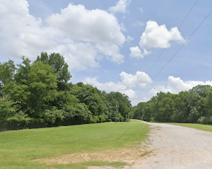
This is a pleasant run on the north side of the Black Warrior River. A gravel-surfaced levee path, also known as the Northport Riverwalk, runs for 2.2 miles. The west end is at 30th Ave. near Kentuck Park. The east end is at 9th Ave. off Martin Luther King Blvd, about 1/2 mile past Rice Mine Rd. There are occasional water views, though much of the path is not right along the water.
Levee Path from 30th Ave. Google Street View
To make this a longer run, we recommend adding a jaunt down to the Oliver Lock and Dam. From the 30th Ave. trailhead, it’;s 0.8 miles each way, and there are some nice water views.
Note: One can combine this with the Riverwalk Path on the south bank, using the pedestrian path on the Hugh Thomas Bridge. However, it’s a major road, and access to the sidewalk requires awkward access points and an unpleasant highway tangle.
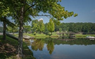
Scroll Down For Route Maps
Essentials
6.1 miles (10 km), including Oliver Lock and Dam
98 feet (30m)
West End: 30th Ave. near Kentuck Park
Parking at 30th Ave. trailhead or Kentuck Park (where there are restrooms)
The signature run in Tuscaloosa. A 2.2 mile paved path along the Black Warrior River, with nice water views. Highlights include Manderson Landing, Queen City Park, and a loop around the Amphitheater. Good add-ons.
We've mapped a 10k loop to use as a guide for running this large, attractive campus. Pedestrian paths around historic buildings and classic quads, the Bryant-Denny Stadium, and a great running track. Can be combined w/Riverwalk.
Combine a run on the 12 miles of trails of the Arboretum with the open, grassy fields of a former golf course. Also adjacent is a ~2 mile perimeter road of the VA hospital and the quiet roads of the Woodland Hills neighborhood.
~11 miles of gravel/dirt trails through a combination of open and wooded terrain in this park located in the Northport part of Tuscaloosa. It's also possible to run on the 1.3 mile park road.
Great spot for easy to moderate trail running in this 1,625-acre park located nine miles northwest of Tuscaloosa. The 23 miles of trails are mainly wooded. Includes 2 miles along Lake Lurleen.
Share your feedback on this route and see that of other Great Runs users. Click on the image icon to upload a photo. And please let us know if there are notes or changes we should incorporate!
Subscribe
0 Comments
Oldest
Newest
Inline Feedbacks
View all comments
Essentials
6.1 miles (10 km), including Oliver Lock and Dam
98 feet (30m)
West End: 30th Ave. near Kentuck Park
Parking at 30th Ave. trailhead or Kentuck Park (where there are restrooms)


Review or Comment on This Route/Share a Photo!
Share your feedback on this route and see that of other Great Runs users. Click on the image icon to upload a photo. And please let us know if there are notes or changes we should incorporate!