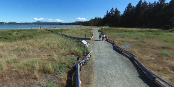
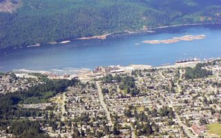
In Parksville, there’s a good variety of running options, including waterfront paths, a runnable beach, a spectacular bridge, and a fairly easy trail run following the Englishman River. With the newly completed pedestrian suspension bridge (Top Bridge), it’s possible to do an ambitious run combining Rathtrevor Beach Park and the RDN Recreational Trail in Englishman River Regional Park.
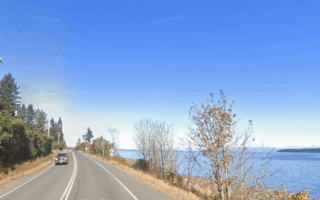
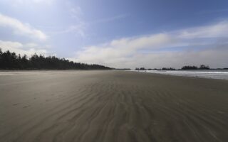
Rathtrevor Beach Provincial Park. This waterfront park features tall trees, a wide sandy beach, and the scenic 2 km Rathtrevor Beach Path — a firm sand path along the beach that features great water views. For longer, see the Top Bridge Regional Trail connector, below.
Top Bridge Suspension Bridge
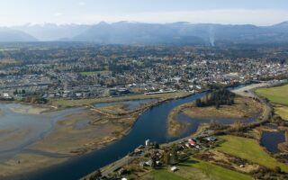
Top Bridge Regional Trail. A new pedestrian-cyclist suspension bridge spanning the English River completes the Top Bridge Regional Trail, which connects Rathtrevor Beach Park to the RDN Englishman River trail. It’s not on most maps, so use the map image below. It’s ~4 km from Rathtrevor Park to the river crossing. PRO TIP: Top Bridge Park is a favourite local swimming hole.
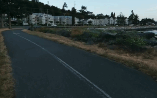
RDN Recreational Trail. This gravel trail in Englishman River Regional Park follows the Englishman River for about 5 km. It’s an easy trail run — fairly wide, with a gentle grade. It’s fairly wooded, with some views of the English River.
In Parksville, there’s a good variety of running options, including waterfront paths, a runnable beach, a spectacular bridge, and a fairly easy trail run following the Englishman River. With the newly completed pedestrian suspension bridge (Top Bridge), it’s possible to do an ambitious run combining Rathtrevor Beach Park and the RDN Recreational Trail in Englishman River Regional Park.
Rathtrevor Beach Provincial Park. This waterfront park features tall trees, a wide sandy beach, and the scenic 2 km Rathtrevor Beach Path — a firm sand path along the beach that features great water views. For longer, see the Top Bridge Regional Trail connector, below.
Top Bridge Suspension Bridge
Top Bridge Regional Trail. A new pedestrian-cyclist suspension bridge spanning the English River completes the Top Bridge Regional Trail, which connects Rathtrevor Beach Park to the RDN Englishman River trail. It’s not on most maps, so use the map image below. It’s ~4 km from Rathtrevor Park to the river crossing. PRO TIP: Top Bridge Park is a favourite local swimming hole.
RDN Recreational Trail. This gravel trail in Englishman River Regional Park follows the Englishman River for about 5 km. It’s an easy trail run — fairly wide, with a gentle grade. It’s fairly wooded, with some views of the English River.
Scroll Down For Route Maps
Essentials
Rathtrevor Beach Path: 2 km; Top Bridge Trail: ~4 km; RDN Recreational Path: up to 6.5 km one-way
RDN Path is rolling hills
Depends on section chosen; Trailhead for RDN Path is off Chattell Rd.
Access Top Bridge Trail at southwest end of Rathtrevor Park; Trailhead for RDN Path is off Chattell Rd.
In this coastal town on the east side of Vancouver Island, there's some nice coastal running and numerous interior forest trails, including the popular Holland Creek Trail loop.
Second-largest city on Vancouver Island and reachable by ferry from Vancouver. We've mapped several scenic running routes: coastal paths, beautiful parks, and extensive trail running options.
A scenic and runnable section of the secondary Island Highway that runs along the coast. It's 10k between Union Bay and Buckley Bay. The road is busy but has a wide shoulder and good water views. Fave section is 6 km from Buckley Bay to Union Bay.
A great way to experience some of Vancouver Island's vast forest lands. This 550-acre protected forest features 200 km of trails and logging roads through lush forest, including cedar groves and riparian areas.
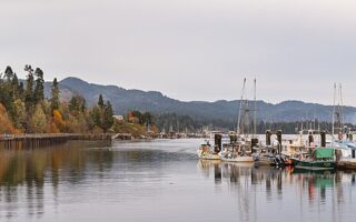
In Courtenay on Vancouver Island's east coast, there's 8 km of scenic waterfront running on paved multi-use paths along Comox Harbour and the Courtenay River. Can vary with the Rotary Trail.
A scenic waterfront run in the "Salmon Capital of the World". The Campbell River Seawalk is a 6.7 km paved waterfront path along Discovery Passage. Great water views! You'll cross the 50th parallel! Also nice forest trails in the Beaver Lodge Lands.
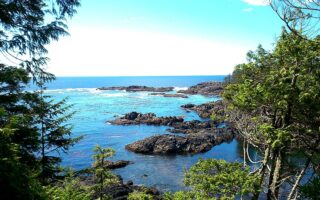
Fantastic beach running at three longer beaches along Vancouver Island's rugged west coast between Tofino and Ucluelet: Chesterman Beach, Long Beach, & Florencia Bay Beach. Crashing surf, gorgeous sunsets!
This 8 km coastal trail is located in Ucluelet, along the island's rugged west coast. Scenic, fairly easy trail running showcasing coastal forests, bogs, and mudlats. There are two main sections, which can be combined.
Terrific running options in this coastal community on the southern tip of Vancouver Island, 38 km west of Victoria. Run the Whiffin Spit Trail, a section of the Galloping Goose multi-use trail, or more rugged trail running in East Sooke Regional Park.
Share your feedback on this route and see that of other Great Runs users. Click on the image icon to upload a photo. And please let us know if there are notes or changes we should incorporate!
Subscribe
0 Comments
Oldest
Newest
Inline Feedbacks
View all comments
Essentials
Rathtrevor Beach Path: 2 km; Top Bridge Trail: ~4 km; RDN Recreational Path: up to 6.5 km one-way
RDN Path is rolling hills
Depends on section chosen; Trailhead for RDN Path is off Chattell Rd.
Access Top Bridge Trail at southwest end of Rathtrevor Park; Trailhead for RDN Path is off Chattell Rd.


Review or Comment on This Route/Share a Photo!
Share your feedback on this route and see that of other Great Runs users. Click on the image icon to upload a photo. And please let us know if there are notes or changes we should incorporate!