This route features a guide to running around Elberfeld — the central and largest district of Wuppertal — with the nearby Hardt, a scenic, hilly park. We’ve created a map to use as a guideline, but you can also create your own route!
Elberfeld Center
Elberfeld is large neighborhood, sprawling both sides of the Wupper River, hilly, ‘staircase’ neighborhoods rising especially on the north side. Create your own 2-3 km route in the historic center on the north side. Start at Laurentiusplatz Wuppertal, a large plaza and pedestrian zone. Get your heart rate up by heading north, crossing Luisenstraße to experience the Tippen-Tappen-Tönnchen steps. Come back down, and use the Herzogstraße — the main east-west pedestrian thoroughfare — with its numerous shops, restaurants, and the Von der Heydt Museum.
Make your way down to the Wupper River and the Döppersberger Brücke, the gateway to the downtown core, where you can also see the Schwebebahn: the world-famous suspension railway runs that runs through the center of Elberfeld, suspended over the Wupper river and city streets. Take a jaunt around the Kluse station and the bridges/paths along the river. Then use Wupperstraße for the 0.5 km access to Hardt Park. It’s a mainly pedestrian street, with some stairs.
Hardt Park
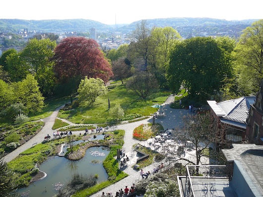
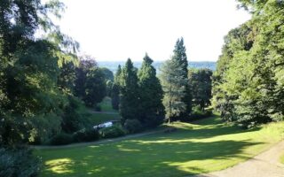
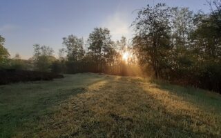
This is a scenic, hilly park near the commercial center of Elberfeld. A network of windy, hilly paths lead pass sprawling lawns, with some wooded sections. At the southeast end is a botanical garden, and the Elisenturm hilltop landmark, featuring great views of the city and river. At the northwest end, a highlight is the Riesen-Mammutbäume — a giant sequoia.
Elisenturm
\Create your own route around Hardt. It’s possible to do 3-4 hilly km in the park: It’s ~1 km east-west along the Elisenhöhe path, and ~0.5 km north-south.
This route features a guide to running around Elberfeld — the central and largest district of Wuppertal — with the nearby Hardt, a scenic, hilly park. We’ve created a map to use as a guideline, but you can also create your own route!
Elberfeld Center
Elberfeld is large neighborhood, sprawling both sides of the Wupper River, hilly, ‘staircase’ neighborhoods rising especially on the north side. Create your own 2-3 km route in the historic center on the north side. Start at Laurentiusplatz Wuppertal, a large plaza and pedestrian zone. Get your heart rate up by heading north, crossing Luisenstraße to experience the Tippen-Tappen-Tönnchen steps. Come back down, and use the Herzogstraße — the main east-west pedestrian thoroughfare — with its numerous shops, restaurants, and the Von der Heydt Museum.
Make your way down to the Wupper River and the Döppersberger Brücke, the gateway to the downtown core, where you can also see the Schwebebahn: the world-famous suspension railway runs that runs through the center of Elberfeld, suspended over the Wupper river and city streets. Take a jaunt around the Kluse station and the bridges/paths along the river. Then use Wupperstraße for the 0.5 km access to Hardt Park. It’s a mainly pedestrian street, with some stairs.
Hardt Park
This is a scenic, hilly park near the commercial center of Elberfeld. A network of windy, hilly paths lead pass sprawling lawns, with some wooded sections. At the southeast end is a botanical garden, and the Elisenturm hilltop landmark, featuring great views of the city and river. At the northwest end, a highlight is the Riesen-Mammutbäume — a giant sequoia.
Elisenturm
\Create your own route around Hardt. It’s possible to do 3-4 hilly km in the park: It’s ~1 km east-west along the Elisenhöhe path, and ~0.5 km north-south.
Scroll Down For Route Maps
Essentials
Create your own route. The 'runseeing' section is 2.8 km, leading to Hardt, with 3-4 of paths.
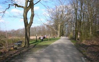
An overview of some of Wuppertal's best parks for running: Hardt Park, Nützenbergpark, Friedrichsberg, Arboretum Burgholz. All are mainly forested and hilly. Trails/paths have generally good footing.
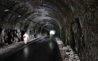
One of the best places in for a longer off-road run in Wuppertal. We've mapped 12 km from Vohwinkel to Wichlinghausen-Süd. The paved trail features fairly gentle grades, and includes five illuminated tunnels and impressive brick viaducts offering views of the city.
This 100-hectare green space is a nice spot for gentle, hilly trail running on mainly forested trails. A loop is ~4 km. There are several adjoining green spaces that allow for a longer run: the open meadows of Scharpenacken, the rugged forest trails of Barmer Wald, and even more in the Murmelbach Valley.
One of the most scenic spots in Wuppertal for a run. Located in the Heckinghausen neighborhood on an elevated plateau, with a rolling hill, open meadow landscape. There are wonderful views into the Wupper Valley. Wide trails, mix of paved & gravel.
Another good spot for a longer off-road run in Wuppertal. This paved rail-trail is located more in the southern part of the city, and runs for 8.5 km from the Wuppertal Zoo south to Cronenberg. It has a green, pastoral feel, with a steady climb over the first 5 km.
Share your feedback on this route and see that of other Great Runs users. Click on the image icon to upload a photo. And please let us know if there are notes or changes we should incorporate!
Subscribe
0 Comments
Oldest
Newest
Inline Feedbacks
View all comments
Essentials
Create your own route. The 'runseeing' section is 2.8 km, leading to Hardt, with 3-4 of paths.
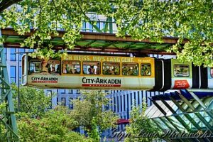 Make your way down to the Wupper River and the Döppersberger Brücke, the gateway to the downtown core, where you can also see the Schwebebahn: the world-famous suspension railway runs that runs through the center of Elberfeld, suspended over the Wupper river and city streets. Take a jaunt around the Kluse station and the bridges/paths along the river. Then use Wupperstraße for the 0.5 km access to Hardt Park. It’s a mainly pedestrian street, with some stairs.

Review or Comment on This Route/Share a Photo!
Share your feedback on this route and see that of other Great Runs users. Click on the image icon to upload a photo. And please let us know if there are notes or changes we should incorporate!