Pemberton is a small town 30 km north of Whistler that’s a popular spot for cycling, hiking, trail running, and backcountry skiing. The town itself lies in a valley surrounded by towering mountains. It’s also a significant farming community, with numerous organic farms stretched along Meadow Rd. Our recommendations for running in Pemberton:
Pemberton Meadows. This is a fantastic spot for a long, flat, open run with great views. Pemberton Meadows Rd. heads out Pemberton and goes for 20+ km until turning into a forest service road. Open farmland, barns, mountains views, and a river — all in one run! The road is relatively traffic-free and there’s a good shoulder. Start at the Community Barn downtown. After 1 mile, turn LEFT to stay on Pemberton Meadows Rd. A ~10 km destination is the The Beer Farmers (farm brewery and tasting room). We’ve mapped the first 15 km one-way, to the intersection of Lillooet Forest Service Rd., where Meadows Rd. turns to gravel and becomes more wooded. Note: Pemberton micro-climate often features a headwind, heading toward Pemberton on the road. ROUTE MAP
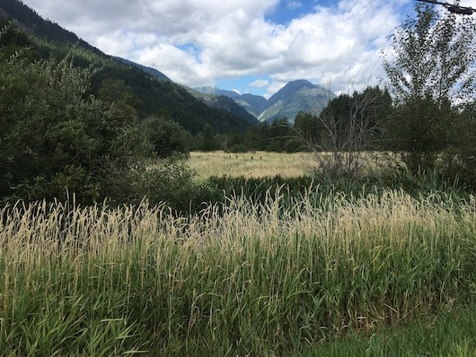
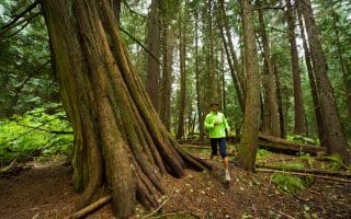
Valley Loop. A gorgeous run right from downtown and the easiest of Pemberton’s numerous trail running options. It’s an 8 km loop, with great views of farmland, meadows, and mountains. It’s mainly a gravel bike path, with options for a parallel narrower, wooded trail along the river in sections. For a longer run, connect to the One Mile Lake loop, and trails for Nairn Falls (below). Numerous access points. TRAIL MAP
Valley Loop Trail. Author Photo
One Mile Lake and Nairn Falls. Just south of Pemberton off Highway 99, this is a spot for a scenic and gentle trail run. A 1-mile dirt path follows the perimeter of One Mile Lake. Then, a section of the Sea to Sky Trail called the Nairn Falls Connector connects to Nairn Falls Provincial Park, where a wide, gentle trail leads to a spectacular waterfall. We’ve mapped a combo route of 9.4 km RT. The Nairn Falls trail itself is 3 km out and back. Note: At the north end of One Mile Lake, the sign for Nairn Falls provides options for easier or hillier routes there.
Trail Running Options. Pemberton has a growing network of mountain bike trails. These can be used for trail running as well, but keep an eye out for bikers. For gentler, more accessible trail running, we recommend sticking to the ‘green’ colored trails. The Valley Loop (above) is a popular option. We suggest picking up an updated trail map at the Visitor Center or at The Bike Co. shop right in town. Downloadable Trail Map, courtesy of the Pemberton Valley Trails Association.
Post-run treat: Blackbird Bakery has fabulous stuff, or enjoy the local Pemberton Brewing Company selections at area restaurants.
Pemberton is a small town 30 km north of Whistler that’s a popular spot for cycling, hiking, trail running, and backcountry skiing. The town itself lies in a valley surrounded by towering mountains. It’s also a significant farming community, with numerous organic farms stretched along Meadow Rd. Our recommendations for running in Pemberton:
Pemberton Meadows. This is a fantastic spot for a long, flat, open run with great views. Pemberton Meadows Rd. heads out Pemberton and goes for 20+ km until turning into a forest service road. Open farmland, barns, mountains views, and a river — all in one run! The road is relatively traffic-free and there’s a good shoulder. Start at the Community Barn downtown. After 1 mile, turn LEFT to stay on Pemberton Meadows Rd. A ~10 km destination is the The Beer Farmers (farm brewery and tasting room). We’ve mapped the first 15 km one-way, to the intersection of Lillooet Forest Service Rd., where Meadows Rd. turns to gravel and becomes more wooded. Note: Pemberton micro-climate often features a headwind, heading toward Pemberton on the road. ROUTE MAP
Valley Loop. A gorgeous run right from downtown and the easiest of Pemberton’s numerous trail running options. It’s an 8 km loop, with great views of farmland, meadows, and mountains. It’s mainly a gravel bike path, with options for a parallel narrower, wooded trail along the river in sections. For a longer run, connect to the One Mile Lake loop, and trails for Nairn Falls (below). Numerous access points. TRAIL MAP
Valley Loop Trail. Author Photo
One Mile Lake and Nairn Falls. Just south of Pemberton off Highway 99, this is a spot for a scenic and gentle trail run. A 1-mile dirt path follows the perimeter of One Mile Lake. Then, a section of the Sea to Sky Trail called the Nairn Falls Connector connects to Nairn Falls Provincial Park, where a wide, gentle trail leads to a spectacular waterfall. We’ve mapped a combo route of 9.4 km RT. The Nairn Falls trail itself is 3 km out and back. Note: At the north end of One Mile Lake, the sign for Nairn Falls provides options for easier or hillier routes there.
Trail Running Options. Pemberton has a growing network of mountain bike trails. These can be used for trail running as well, but keep an eye out for bikers. For gentler, more accessible trail running, we recommend sticking to the ‘green’ colored trails. The Valley Loop (above) is a popular option. We suggest picking up an updated trail map at the Visitor Center or at The Bike Co. shop right in town. Downloadable Trail Map, courtesy of the Pemberton Valley Trails Association.
Post-run treat: Blackbird Bakery has fabulous stuff, or enjoy the local Pemberton Brewing Company selections at area restaurants.
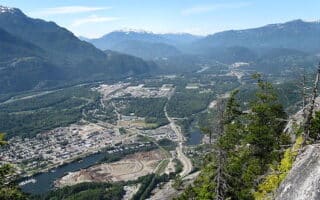
Outdoor recreation mecca at the north end of Howe Sound in the Sea to Sky Corridor. Favorite runs are Oceanfront Loop, Spit/Estuary Trail, Squamish River Trail, Sea to Sky Connector Trail. And a wealth of trail running options.
A 40 km paved muli-use trail that's a great off-road connector to the major parts of Whistler. Some of the best sections for running are Alta Lake to Alpha Lake, Rainbow Park to Meadows Park, a loop around the golf course, and along Green Lake.
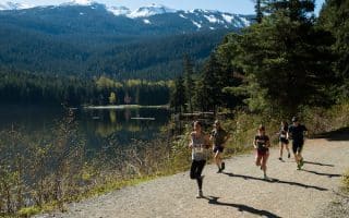
One of the most popular spots to run in Whistler. This wide, gravel trail around the lake is ~2 km, with occasional water views. From Whistler Village, it's a 5.8 km route. Bonus: lit at night!
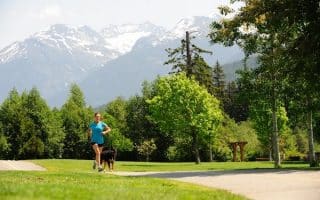
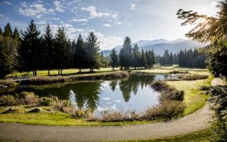
The section of the Valley Trail that forms a 4.7 km loop around the Golf Course is another popular and easily accessible run in the Whistler area. Right across from Whistler Village. Open and pretty, with great add-on opportunities.
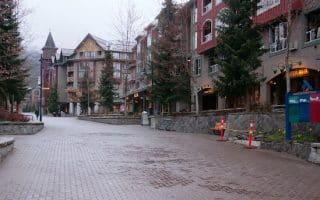
Outside of Highway 99, there aren't a lot of roads in this area. For those who want a break from the trails or some variety, here are our recommendations for some of the quieter roads for running in the Village and area neighborhoods.
Our recommendations for some of the best easy-to-moderate trail running in the valley, all within a few km of Whistler Village. Interpretive Forest/Cheakamus River, Emerald Forest, XC trails in the Lost Lake area, & more.
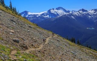
Take a lift up to the alpine to enjoy spectacular trail running opportunities on Whistler-Blackomb. We've compiled some recommendations for easy-to-moderate routes among the 50+ km of gorgeous hiking trails.
Share your feedback on this route and see that of other Great Runs users. Click on the image icon to upload a photo. And please let us know if there are notes or changes we should incorporate!


Review or Comment on This Route/Share a Photo!
Share your feedback on this route and see that of other Great Runs users. Click on the image icon to upload a photo. And please let us know if there are notes or changes we should incorporate!