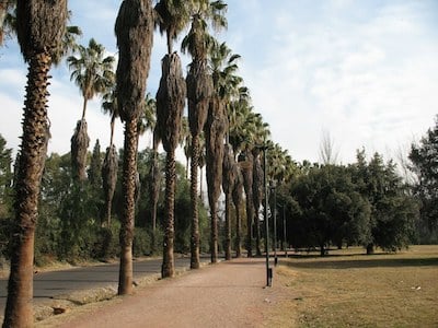
Parque General San Martín is the iconic running spot in Mendoza. The expansive urban park features a lake, a rose garden & promenades lined with statues. One create their own route of 7-8 km without overlapping. There are some designated paths in the park, and most of the main roads also have cycle paths alongside. Bonus: most paths lit at night!
A loop around the lake on the ‘peatonal’ walking paths is ~2.5 km. Add to this with some of the roads/paths near the lake. There’s a running track, near the stadium at the northern end of the park, off Av. del Libertador.
Path Along Road. Creative Commons.
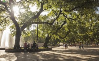
If you want to access Parque General San Martín from the heart of Mendoza, there are pleasant, tree-lined streets through the Quinta or Sexta sections of the city. Av. Colón/Av. Arístides Villanueva is a pretty street with nice trees, shops, & restaurants. It’s ~2 km from Plaza Independencia to the park.
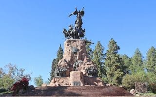
At the western end of Parque General San Martín is the scenic, hilly Cerro de Gloria area, popular with trail runners. It starts just west of Av. San Francisco de Asís. Take in a panoramic view of Mendoza and climb the stairs to the monument of San Martin. There are additional trails in the area — see our route.
Parque General San Martín is the iconic running spot in Mendoza. The expansive urban park features a lake, a rose garden & promenades lined with statues. One create their own route of 7-8 km without overlapping. There are some designated paths in the park, and most of the main roads also have cycle paths alongside. Bonus: most paths lit at night!
A loop around the lake on the ‘peatonal’ walking paths is ~2.5 km. Add to this with some of the roads/paths near the lake. There’s a running track, near the stadium at the northern end of the park, off Av. del Libertador.
Path Along Road. Creative Commons.
If you want to access Parque General San Martín from the heart of Mendoza, there are pleasant, tree-lined streets through the Quinta or Sexta sections of the city. Av. Colón/Av. Arístides Villanueva is a pretty street with nice trees, shops, & restaurants. It’s ~2 km from Plaza Independencia to the park.
At the western end of Parque General San Martín is the scenic, hilly Cerro de Gloria area, popular with trail runners. It starts just west of Av. San Francisco de Asís. Take in a panoramic view of Mendoza and climb the stairs to the monument of San Martin. There are additional trails in the area — see our route.
Scroll Down For Route Maps
Essentials
7-8 km of roads with paths alongside. Lake loop is ~2.5 km
In park
There's parking at the park. Good bus access. Also can access from downtown -- it's 2 km from Plaza Independencia
A 'runseeing' tour of the central part of Mendoza, with its wide, tree-lined streets and numerous green squares. We've mapped a shorter 'central squares' route and longer route adding the Quinta neighborhood to Parque General San Martín.
Just west of Parque General San Martín, those who like hills will be rewarded with the run up the Cerro de la Gloria. A 100m climb over 1 km, with great views. Other trails for running just south of there.
Not the most scenic, but one of the best opportunities for a longer off-road run in Mendoza. The paved multi-use path starts downtown and heads south for up to 6.3 km into the Godoy Cruz area, terminating near Parque Benegas.
Share your feedback on this route and see that of other Great Runs users. Click on the image icon to upload a photo. And please let us know if there are notes or changes we should incorporate!
Subscribe
0 Comments
Oldest
Newest
Inline Feedbacks
View all comments
Essentials
7-8 km of roads with paths alongside. Lake loop is ~2.5 km
In park
There's parking at the park. Good bus access. Also can access from downtown -- it's 2 km from Plaza Independencia


Review or Comment on This Route/Share a Photo!
Share your feedback on this route and see that of other Great Runs users. Click on the image icon to upload a photo. And please let us know if there are notes or changes we should incorporate!